CHAPTER 3 – TURNING LAND INTO MONEY FROM 1781 TO
1796
The
following is paraphrased from material provided by the Massachusetts
Archives, author unknown. Some material has been deleted and I’ve added
some material where appropriate. jd
In May of
1781 a committee of both houses of the General Court had been
appointed to clarify rightful land claims in Maine and identify
trespassers. The committee of five was instructed to accept payments
from squatters for damages done to Commonwealth land, and to report to
the General Court if purchase of the land was desired.
In 1783
the Commonwealth of Massachusetts owned 17 million acres of land in
Maine. It also had a huge war debt of five million dollars, and its
share of the national war debt was another five million dollars. The
Commonwealth treasury was virtually empty, so Governor John Hancock
hoped to turn these largely unsettled, and for the most part not
surveyed, Maine lands into cash. In his message to the Legislature in
1783, Hancock called for land sales as a substitute for taxation.
Following
Hancock's recommendation, the General Court appointed a second committee
in July of 1783, to survey, appraise and sell land in the District of
Maine. The counties of Maine were then York, Cumberland, and Lincoln.
Hancock and Washington would be set off from Lincoln County in 1789.
Preference
was given for sales of land in small parcels. The land was to be
surveyed and divided into townships of six square miles, one half of
which were to be sold in 500-acre lots and half of which were to be sold
in 150-acre lots. Townships were sold undivided only to proprietors who
agreed to settle 60 families in the townships within 6 years. Between
1785 and 1789 the committee had surveyed 28 townships and numerous
islands.
As a
homeowner plants a hedge at his property edge, the government of
Massachusetts (Maine was part of Massachusetts then) wanted to plant
settlements along its border with English Canada. Rufus Putman was sent
in 1784 to survey the land, to organize the wilderness into
townships for settlement.
Here is a
little about RUFUS PUTNAM, a talented and busy man!
Rufus Putnam
was born at Sutton, Massachusetts on April 9, 1738. He died at Marietta,
Ohio on May 1, 1824. He was apprenticed in 1754 to a millwright, but
acquired some knowledge of surveying and later found employment in that
profession. In March 1757 he enlisted as a private for service in the
French and Indian War, and re-enlisted yearly until 1761, being made
ensign in 1760. His story of the campaigns in which he served may be
read in the Journal that he kept throughout.
Putnam was a
farmer successively at New Braintree, Mass. (1761), Brookfield, Mass.
(1765) and Rutland, Mass. (1780). In 1773 he went to Florida as one of
an investigating committee appointed to examine lands granted by the
Crown to Colonial soldiers and officers who had fought in provincial
regiments during the French and Indian War. He was made deputy-surveyor
of Florida by the governor of the province and accompanied the
expedition up the Mississippi to the Yazoo, up the Yazoo to Haines'
Bluff, back to the Big Black and thence in return down the Mississippi.
He planned and directed the construction of the Continental lines of
defense at Roxbury and for the excellence of his work was detailed by
Washington as acting chief engineer of the army.
On Aug. 11,
1776 Putnam was appointed by Congress chief engineer of the army, with
colonel's rank; but preferring service in the field, he resigned in
December and took command of the 5th Massachusetts Regiment. With the
northern army in 1777 he did conspicuous service, particularly at
Stillwater, where he headed the 4th and 5th regiments of Nixon's
brigade. On Jan. 7, 1783 he was promoted brigadier general. He was for
several years a member of the Massachusetts legislature and during
Shays' Rebellion (1786-1787) was a very efficient aide on the staff of
Gen. Benjamin Lincoln. In March 1787 he was chosen (with Gen. S. H.
Parsons and Rev. Manasseh Cutler) a director of the Ohio Company,
organized on March 1, 1786 with a capital of $1,000,000 in public
securities, to be expended in the purchase of land in the Northwest
Territory. In July a contract was made with Congress for one and a half
million acres and soon afterward an ordinance, familiarly known as the
"Ordinance of 1787," was passed, providing for the government of the
Territory.
On April 7,
1788 Putnam, meanwhile made superintendent of the company, landed with a
party of emigrants at the mouth of the Muskingum and on the present site
of Marietta commenced the first organized settlement in the Northwest
Territory. He concluded in 1792 at Vincennes a treaty with eight tribes
of the Wabash Indians and in 1793 resigned his commission in the army.
Putnam was
one of the Judges of the United States court in the Territory,
1790-1796, and from 1796 until his removal by Jefferson for political
reasons in 1803 was surveyor general of the United States. He was the
founder of the first Bible society west of the Alleghenies (1812), a
sturdy Federalist in politics and, with the exception of Lafayette, the
last survivor of the general officers of the Continental Army.
Maine seldom
gets into national history books, and eastern Maine often isn’t
mentioned in Maine history books. We note that Putnam’s surveys in Maine
did not get mentioned in the above quoted article. Rufus Putnam did a
lot of surveying between the Penobscot and Schoodic Rivers. He also kept
detailed journals, partly to record the bounds of the land he surveyed,
to detail his expenses, and apparently, because he was good diarist. Ken
Smith of Chases Mills, East Machias gave A-CHS a typed copy of Putnam’s
1784 and 1785 journals as they pertained to this area. The following is
taken from that source. My comments are in [parenthesis].
1784 SURVEY BY RUFUS PUTNAM
August 2,
1784 ~ Set out from Rutland on my way to the Bay of Passamaquoddy for
the purpose of surveying ten townships of land agreeably to contract
with mister Samuel Philips and Nathan Dane, a committee of the
commonwealth for the selling of government lands in the county of
Lincoln. [Washington and Hancock counties were set off from Lincoln
County in 1789]
August 7 ~
Lt. Park Holland arrived in Boston who is going in partnership with me….
August 26 ~
This morning myself and Mr. Park Holland were sworn as surveyors and
Elijah Hammond, William Waite, Samuel Mercy, Joseph Maxwell were sworn
as chain men and in the evening we all left Boston in the schooner
“Nancy”, Mr. McGowen Master.
August 31 ~
At 12 o’clock lay alongside Col. Stillman’s wharf at Machias Mills.
[Remember George Stillman whose name come down to Alexander born George
Stillman Smith Scribner]
September 1
~ Called on Mr. Samuel Holmes [of Cross Island] who informs that there
is no good land between the township of Machias and Cobscook … that the
whole consists of spruce swamps … and fir ridges except some small spots
on Little Machias and Little River….
September 2
~ From Cross Island {to Cobscook Bay] is, in general, horrid iron bound
shore…. Little River [is] a very good harbor for shipping of any
burthen. From the north east part of Flagg's Point [Lubec] to [Col.
John] Allen’s store on south point of Dudley’s Island is north by needle
and a distance about one mile. (Allen named his island after
Massachusetts Governor Dudley.)
September 3
~ Arrived at Capt. Frost’s on Pleasant Point which is a most delightful
situation, the best potatoes I’ve seen anywhere this year; his oxen are
excellent beef without an advantage but the common run of his pasture;
and his sheep the finest I’ve ever seen without exception. Capt. Frost
raises German barley.
September 4
~ [Putnam and Capt. Frost explore by water the branches of Cobscook Bay
which he calls a Cobscook River. They pass Edmund Mahar’s house and the
mill run by Mahar, Samuel Leighton and Nathan Preston. They see where
General Crane is building a mill at the place where the inland route to
Machias waters for use with birch canoes.]
September 5
~ [Sunday is a day of rest, the men do not get paid, and usually no
entries are made in Putnam’s journal.]
September 6
~ I have contracted Mr. Josiah Flagg at 6/ a day and subsistence … a
guide well acquainted with the country, [and we] reconnoitered the
southerly part of No. 1 [Perry]. [At the end of the day] I marked a
white pine for the dividing bound between No. 1 and No. 2 [Perry and
Pembroke] by blazing the northerly and southerly side and with a marking
iron thus 1784 and made a heap of stones by the root of the same, then
camped. [Following are the first of many “Minutes of Survey Taken by Mr.
Holland” starting] on a point of land by Joseph Bridges house.
Thus starts
the surveying of the bounds these seven townships: #1 PS = Perry, #2 PS
= Dennysville and Pembroke, #3 PS = Charlotte, #4 PS = Robbinston, #5 PS
= Calais, #6 PS = Baring, and #7 PS = Baileyville. The PS stands for
Putnam’s Survey. (Note that Meddybemps was cut out of Baring, Charlotte
and Cooper in1842) He even surveyed lots within some or all of these
townships. Along the way he noted trees and grasses, soils, swamps and
ridges, lakes, streams and rivers, mill seats
He found
where Robert Wilson of Campobello had started a mill [Wilson Stream] and
surveyed up the Dennys River to where Capt. Roggers proposed to build a
mill. They visited Devils’ Head on the Schoodic River [St. Croix] and
saw Jacob Libby’s house opposite Schoodic Falls. Jacob settled in St.
Stephen, near the site of the present police station. They spent half a
day carrying supplies around Schoodic Falls to above Ayers Mill. He saw
at Megorriwack Creek a fine meadow with 15 large stacks of hay. Park
Holland observed that some of the land around Meddybemps Lake “was
burnt”.
October 5 ~
Severe frost last night which made considerable ice and snow which fell
last evening in many places till 12 o’clock this day.
In spite of
the cold weather, Putnam continued surveying until he had finished. On
October 19, he was at Calais, on the 21st at Capt. Frost’s, and on the
26th they departed for Machias and then home.
On June 6,
1885, he again set out from Rutland for eastern Maine. Between
then and November Putnam and his crew surveyed townships #8 = Trescott,
#9 = Eastport (which then included Lubec), #10 = Edmunds, #11 = Cutler,
#12 = Whiting, and #13 = Marion. All this activity makes one wonder how
Putnam found time to be a successful farmer! It was also in 1785 that
Putnam was added to the committee responsible for turning these Maine
lands into money for the Commonwealth.
Who was
PARK HOLLAND
Park Holland
was born in 1752 at Shrewsbury, Massachusetts. He was active in the
Revolutionary War, at Harlem Heights, White Plains, Bennington and
Saratoga. He was involved in putting down Shays’ Rebellion In January
1785 he married Lucy Spooner and spent the next five years, the happiest
in his life, engages in tilling the land in Petersham, a Captain in the
Militia, a selectman, assessor, and representing his town in the General
Court.
He then came
to Maine, living at Eddington, where he surveyed some of the northern
townships for Bingham. He, along with Titus Goodman and Jonathan Maynard
were land speculators, buying what now are Grand Lake Stream, Waite, and
Talmadge. He moved to Orono, then to Bangor where he died in 1844. As an
old man he wrote his autobiography in which he describes the 1794 survey
of Bingham’s Option, a lot 36 miles wide and running north 140 miles.
This lot was north of the lottery land. Source: Park Holland,
Revolutionary Soldier, Maine Surveyor complied by Philip Coolidge
CREATING A MAP/PLAN
When it was
decided to have the lottery, the thirteen Schoodic townships described
above had been surveyed as had some townships along on the east side of
the Penobscot River. In 1763 John Jones and Joseph Frie had surveyed
seven coastal townships from Trenton east to Addison. The north boundary
line of these townships was called the ‘Grand East and West Line’. In
1786 Rufus Putnam, who was on the Land Commission, created a map/plan
for the Middle Division based on this line. This map/plan showed the
“townships in red lines delineated for surveying.” He did this while in
Boston; his map/plan had no lakes or rivers in it. These townships were
six miles by six miles or 23040 acres. The present day bounds of these
townships have changed little since 1795.
Putnam
already had a survey of the Schoodic Townships (#1 PS - #13 PS), so
needed to fill in the gap between them and the Middle Division. Thus we
have townships #14 ED BPP to # 27 ED BPP. Middle Division townships were
based on the magnetic meridian and the Schoodic (Putnam Survey)
townships had been surveyed on a line 20 degrees west of North.
Therefore Putnam had to adjust for these differences, which accounts for
the odd shape of several of these townships. He attempted to make these
townships the same size as those in the Middle Division. This is obvious
when one looks at the 1786 map/plan Putnam “attested” to most, but not
all, of the map/plans for the lottery.
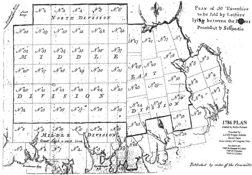
1786
Township 16 [now Alexander] delineated in Massachusetts Land Lottery
map/plan.
FILLING IN THE DETAILS ON PUTNAM’S MAP/PLAN
As mentioned, the
map/plan had no natural features. Several men filled in these details
over the years.
John Peters of Blue Hill surveyed for
the land committee, actually creating boundary lines and placing corner
markers for many townships. He also mapped the rivers and lakes that are
shown on Osgood Carleton’s 1795 map in the center of this newsletter.
This was a result of a contract between Peters and General Jackson (on
behalf of William Bingham) dated May 24, 1793.
John Peters, Jr. and his brother James
Peters, and their brother-in-law Reuben Dodge and his son Addison Dodge
were also surveyors who surveyed lots within townships mostly in Hancock
County. Park Holland of Eddington filled in details in some of the North
Division. In our Downeast area, Benjamin R. Jones of Dennysville and
Richard Hayden filled in the details of many townships including
Alexander and Crawford.
Who was
BENJAMIN R. JONES
Samuel
Jones, a land surveyor, came to Robbinston, Maine in 1788, employed by
Gov. Robbins, founder of the town. His wife, Mary (Richards), was a
descendant of Mayflower passengers, John Alden and Priscilla (Mullens).
The first six Jones children were born in Massachusetts, the last two in
Robbinston. When the Dennysville Congregational Church was organized in
1805, Samuel Jones and his eldest son, Samuel, Jr. were among the
original members. In his old age Samuel, Sr. moved to Eastport where he
died in 1824. His wife, Mary, died in 1815 in Robbinston.
Benjamin R.
Jones, second son of Samuel, Sr., and Mary Jones, was born in Brookline,
Mass., in 1773 and came to Robbinston with his parents and siblings in
1788. In 1798-9 he married Mehitable Hersey, daughter of Zadock and
Abigail (Lewis) Hersey of Dennysville (That part of the town which
became Pembroke in 1832). Mehitable, "Hitty" was descended from Richard
Warren, another Mayflower passenger.
In 1804
Benjamin, Hitty, and their three children had moved to Edmunds where six
more children were born. It is believed that their home was the ell of
the structure which recently was known as the Heritage House (Thomas
Eastman, Jr., built the main house in later years. The house burned in
1993). About 1850 the Jones family moved to the Narrows Road in
Dennysville, living in the house which in later years was occupied by
Edward and Rebecca (Ward) Leighton, succeeded by their son and
daughter-in-law, Leigh and Florence (Jamieson) Leighton.
Like his father, Benjamin R. Jones was a land surveyor. He was so known
for his accurate knowledge, his clerical expertness, and his skill in
making plans, maps, and models that his services were in demand not only
throughout the Dennysville-Edmunds community but also in a large part of
the county. Realizing the importance of academic education, Mr. Jones
read avidly about history, science, and the annals of families all over
the country. He opened an evening school for young people, teaching with
no compensation except his own satisfaction. He also taught singing
schools and writing schools. He was a notable asset to the community.
Copied from Dennys River Historical Society Newsletter, Jan. 1999
MASSACHUSETTS LAND LOTTERY
Approximately 100,000 acres of land had been sold in small parcels by
1786. Eager to escalate sales, the General Court passed a resolve in
November of 1786 instituting a land lottery. Under the direction of John
Brooks and Leonard Jarvis, 50 townships were divided into 2,760 lots of
various sizes. The largest lot was an entire township, TWP 42 Middle
Division. It was called the Grand Prize and the winner would get 21760
acres. TWP 42 is in northern Washington County. No one drew the lucky
ticket.
Tickets were
sold for 60 pounds each, every ticket yielding some prize, though
acreage and quality were to be dictated by a chance drawing. The drawing
took place in June 1787. In Alexander 12 tickets were sold for 720
pounds. The tickets were for a total of 6240 acres. Sixty Massachusetts
pounds of 1786 would be about equal to $2640.00 (1991) dollars. As an
additional incentive, lottery lands were exempted from property taxes
for 15 years, and settlers on lottery lands were exempted from the poll
tax for the same amount of time.
Even with
these benefits attached, only 437 tickets were sold, yielding an income
to the Commonwealth of $86,200. For those with capital to invest, it was
better to buy land that was good land. These tickets were legal
documents for the lots. Since the lots drawn were scattered, the
commissioners offered deeds to those who would trade their lot for an
equal number of acres within four townships. Those East Division
townships were #13 (Marion), #14, #15 (Cooper), and #18, all here in
Washington County.
A resolve in
1788 set the requirement that 4 lots in each township surveyed be
reserved for public use. One lot was to be reserved for the first
settled minister, one for the use of the church, one for a public
school, and the fourth was to be disposed of by the General Court at a
later date. Also in an attempt to quiet angry squatters, the resolve
entitled all settlers who had located on Commonwealth lands prior to
1784 to 100 acres of land at a nominal fee.
By 1790 it
had become clear that receipts from sales did not cover administrative
selling costs. Thus ended the Land Lottery.
WHO PURCHASED TICKETS ON ALEXANDER LAND?
John
Atkinson of Boston drew ticket 712 that was for lot 13 ~ 1280 acres.
Atkinson also acquired two lots in Hancock County in the lottery,
William
Bird, merchant of Boston, drew ticket 687 that was for lot 48 ~ 160
acres.
Jon’ Dwight,
merchant of Springfield, drew ticket 142 that was for lot 26 ~ 160
acres. Dwight purchased at least five other lottery tickets, getting
land in Plantation #14, Wesley, and TWP #30, plus others.
Heirs of
Silvester Gardner of Boston drew ticket 663 that was for lot 49 ~ 2560
acres. The heirs bought at least 9 other tickets, one for land in
Princeton. Gardiner (1708 - 1786) was a self-made man, a surgeon,
druggist, businessman, strong willed, outspoken, religious, a Tory and
an exile. He was one of a group of Boston men who in 1749 acquired
control of the Plymouth Patent. That was granted in 1606 and became part
of the Plymouth Colony’s property. The grant originally was 15 miles
each side of the Kennebec River extending from the ocean to the river’s
headwaters. Gardiner became active in the development of this 1,500,000
acre piece of land. When Gardiner fled this country during the American
Revolutionary War, all his property was confiscated, except this
Kennebec Purchase. Upon his death, the property passed in trust to his
son William and then to his grandson, Robert Hallowell, who added
Gardiner to his name, as required by Silvester’s will. Colonial
Entrepreneur, Dr. Silvester Gardiner by Olivia Coolidge is an excellent
book.
Frederick
William Gayar, merchant of Suffolk County, drew ticket 653 that was for
lot 24 ~ 160 acres.
Daniel Waldo
Junt, merchant of Worcester, drew ticket 761 that was for lot 14 ~ 320
acres.
Christopher
Marshall, gentleman of Boston, drew ticket 185 that was for lot 47 ~ 320
acres.
John Peck,
broker of Boston, drew ticket 776 that was for lot 31 ~ 160 acres. Was
this the John Peck who in 1773 wrote the poem “A Description of the Last
Judgement, with Some Reflection thereon, the Happiness of Being Ready,
and the Misery of Being Unready for such Day”?
Samuel
Pickering gardener of Boston drew ticket 1829 that was for lot 28 ~ 160
acres.
Mrs. Eunis
Ray of Boston drew ticket 771 that was for lot 9 ~ 320 acres.
James
Thatcher, physician of Plymouth, drew ticket 603 that was for lot 7 ~
320 acres.
William
White, merchant of Almsbury, drew ticket 779 that was for lot 42 ~ 320
acres. He also got a lot in TWP #27 in the lottery.
WHAT HAPPENED TO THE LOTS SOLD IN ALEXANDER?
Alexander
had no settler by the land lottery. Apparently not one paid taxes (after
1801) as was required. All the lottery lots, except for one, were sold
by the Alexander tax collector during the 1820s. Robert Hallowell
Gardner, heir of Silvester Gardner, paid the back taxes in 1821 and sold
lot 49, now lot 97, to Caleb Cary of East Machias.
WHAT HAPPENED TO THE LAND NOT SOLD IN THE LOTTERY?
In 1791
the committee sold two million acres of Maine land to Colonel
Henry Jackson of Boston and Royal Flint of New York. That
deed was dated July 1, 1791. The land involved was half on the upper
Kennebec River (known later as Bingham’s Kennebec Purchase) and half the
old lottery lands between the Penobscot and Schoodic Rivers (known later
as Bingham’s Penobscot Purchase). We should note that this sale excluded
the lots sold by the land lottery, and those lots reserved for the first
settled minister, the church, the public schools, and for later use by
the Commonwealth (i.e. the government).
On July
25, 1791 Jackson and Flint assigned their ownership to General Henry
Knox of Boston and William Duer of New York. We should note here
that even though the price was but 10 cents per acre, both of these
transactions were credit deals. One wonders why the short turn around on
this huge piece of property. Was it because Knox was Secretary of War?
Knox was literally the biggest general in the Revolutionary War,
weighing over 300 pounds. It was he who dragged the cannons from Fort
Ticonderoga to Boston in the winter of 1775 - 76 to keep the British
from leaving the city to harass the people in the countryside.
Knox went to
William Bingham, a wealthy speculator from Philadelphia in
December 1792. William Duer was in debtors’ prison and Knox was not far
behind him. Bingham made the necessary arrangements and on January
28, 1793 was given 16 deeds for the two million acres described
above, including the million acres in our Downeast Maine. Land
commissioners Samuel Phillips, Jr., Leonard Jarvis, and John Reed signed
these deeds. Having Bingham and his corporation seemed to offer an
immediate and reliable flow of cash into the Commonwealth treasury.
Unfortunately, this was not the panacea for the eastern lands problem
and Bingham faced financial problems. .
Bingham
turned to Baring Brothers Bank in London for financial backing. A young
son of Sir Francis Baring was sent to America to bargain with Bingham.
Alexander Baring arrived in the fall of 1795 and early the next year
acquired an undivided interest in Bingham’s two million acres of Maine,
including what is now the town of Alexander. Baring appointed John Black
to work with Bingham’s agent General David Cobb to turn the land into
money. The plan was to sell lots to farmers.
1796 Survey
by Americans and British to find the true St Croix River that was the
boundary according to the 1883 Treaty of Paris that divided the USA from
British North America
THE STAGE HAS BEEN SET FOR SETTLEMENT
1000 – 1603 THE EXPLORERS
1607 – 1763 THE CENTURY AND A
HALF OF CONFLICT AND WAR
1763 – 1783 THE COAST IS
SETTLED AND THE NEW NATION IS ESTABLISHED
1785 –1808 THE LAND IS
SURVEYED
1791 - 1796 DEEDED OWNERSHIP
AND WILLING SELLERS
1796 Alexander Baring toured
Hancock and Washington Counties prior to investing.
Liberty Men
and Great Proprietors, The Revolutionary Settlement on the Maine
Frontier, 1760 – 1820 by Alan Taylor gives an excellent picture of
problems faced by those who settled before deeds were available.
|