|
ESSAY
– A brief literary composition on a special
subject –
The essays that follow were written by John
Dudley and were submitted by our Alexander correspondent Cassie
Oakes to the Calais Advertiser. The subject matter is local
history with the attempt to connect historic events to our place and
to our time. The first submissions were part of her news column.
Later, the essays became a column on their own. A number of the
early short pieces were incorporated into later essays. The first
found in the Advertiser was on June 12, 2014; it appears here as
part of the October 16, 2014 essay.
(Images did not appear in The
Calais Advertiser.)
WWII AND THE POW CAMP
June 26, 2014
Did you
know that in the spring of 1944 a Prisoner of War camp was
established at the recently abandoned CCC camp on Indian Township?
Between 250 and 500 German prisoners were housed here until mid
1945. Most were under age 24 and had been captured in North Africa.
These men worked in the woods, mostly cutting pulpwood. The local
men who had done this job were off to war! One place here in
Alexander where POWs cut was on lot 58, Floyd Hunnewell trucked the
pulp to Woodland and Charlie White was his striker. The POWs were
expected to cut only ¼ cord per day.
When our
men came home from war, they weren’t content to work summers on
the farms and in the woods in winter, Also machines like tractors,
chainsaws and skidders meant fewer workers were needed. Fewer jobs
lead to population decline.
STOWELL-MACGREGOR MILL
July 10, 2014
Did you
know that before the days of plastic, Alexander had an important
industry linked to the making of clothing? Cloth may have been made
in huge textile mills, like the mill in Milltown NB, but much of the
clothes were made in family homes by women sewing together pieces of
cloth into shirts and pants. Thread was needed for that task and
thread was purchased on spools made of white birch wood.
Stowell-MacGregor Corporation opened a white birch spool bar mill in
1933 on the shore of Pocomoonshine Lake. It changed white birch
trees into one-inch square bars. These bars were dried, then hauled
by truck to South Lincoln. There they were turned into spools for
Coats and Clark Thread Company. The spool bar mill in Alexander
employed many local men in the mill and in the woods during hard
economic times.
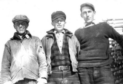
Floyd
Hunnewell, Kenneth McPheters & Vinal Perkins in 1937 in Sticking
field
A
VISITOR FROM THE PAST
July 17, 2014
Did you know why Gary Kinney
called on June 28th?
He had two visitors who were interested in the Edwin Robb homestead.
They were Kay Robb Splitz and her daughter Brenda. John Dudley made
a copy of the article on the history of the Robb Hill Road for them,
and Gary took them to the old house site. Kay remembers walking from
there to school in Baileyville. The Loverin District School had
closed its doors in 1929. She walked down the hill the last time in
1943, bound away for the world beyond Alexander and Baileyville. Her
grandfather Hugh Robb was a Civil War soldier, he went away, but he
came home to live. Kay came home to visit! Here is a little about
Kay’s family.
Edwin (1868) Robb, son
of Hugh (1831), was living in Baileyville in 1930, apparently on
Robb Hill, with his wife Catherine “Kate” (1890) Robb. She was the
daughter of John (1846) and Susan (Porter) Robb. They were married
November 23, 1904. Their children are Michael (b. 1906), Helen (b.
1910 - m. Haskins), and Margaret (b. 1912 - m. Greenlaw). Mabel
(b. 1914 – m. Redding), Frances (1916), Joseph (1922), Phyllis
(1924), and Kathlyn (b. 1927 – m. Splitz). Alice (Varnum) Williams
adds to this list Eva (m. Stickney), John, and Paul (m.
Drotar). Edwin died in 1837 and Catherine in 1949.
More
information on the Robb Family can be found on Brenda’s site <my
heritage.com/robbfamilywebsite>.
MICHAEL FOLEY
July 31, 2014
Did you know that
Michael Foley lived on
Breakneck Mountain? He was born in Ireland in 1840 and came to
America with his father John. He enlisted in Company A, 9th
Regiment Infantry, Maine Volunteers on September 22, 1861. His three
years were up and he re-enlisted on January 1, 1864 in the Maine
Veteran Volunteers. He was killed at the Battle of the Crater near
Petersburg, Virginia on July 30, 1864, 150 years ago.
EASTPORT TO ALEXANDER IN 1821
August 21, 2014
Did you know that a road from Eastport to
Alexander existed before 1821? A petition that year signed by Simon
Porter and 5 others to the County Commissioners requested that the
“road now traveled from Eastport Bridge to … Township 16 [now
Alexander] to intersect with the road from Machias to Calais might
be improved and straightened.” The road ran through Perry to the
“Lower Bridge on Pennymaquan Stream in Dennysville {now in village
of Pembroke], followed the river up the Mount Tom Road and via 214
to the foot of MacDougal Hill [now Conant Hill] and then through the
village of Gilman’s Mills [now Meddybemps]. Next the way followed
the Green Hill Road over Green Hill and through the low lands to the
Cooper/North Union Road near the Flood Cemetery at 856 Cooper Road
in Alexander. How many settlers traveled that road to Alexander?
Have you ever traveled over parts of that original road? Does it
still need to be improved?
CELL TOWER
September 4, 2014
Did you know that Earl Hill took pictures of the
tower at 1790 Airline Road being erected? That was on July 21, 2014.
He then had the foresight and kindness to pass the images on paper
and on a disk to the local historical society where they are stored
in the archives. Thank you, Earl. The August 7 issue of the Calais
Advertiser had an article about U. S. Cellular, the company that
owns the tower. Did you know that the site is connected to EMEC and
FairPoint?
We all know that this tower is the tallest
structure in Alexander. How tall is it? Will its owner pay property
tax in Alexander? What is its expected life span? Did you know that
in many parts of the world cell phone service is provided via
satellites?
Did you know that the events that happen every
day become history? Cassie’s column is an important part of
Alexander- Crawford history. Thank you, Cassie.

PANAMA CANAL
September 11, 2014
Did you know that the Panama Canal was opened for
business on August 15, 1914, and that there is a strange and deadly
connection between that place and Alexander? The Canal cuts through
the Isthmus of Panama, the narrow land bridge that connects North
America to South America.
Gold was
discovered in California in 1847, News traveled slowly in those days
so we remember the 49ers heading for the gold fields. They had three
ways of getting there. Overland to St. Louis by rail, then by wagon
train to California, on a sailing ship all the way around Cape Horn
or by ship to the Isthmus of Panama, across by mule or on foot, and
by ship to San Francisco.
Giles Hutchins was born on June 23, 1810. He
married Eliza Bailey on September 17, 1835. She was the daughter of
Nathaniel and Mary Frost Bailey, which makes Eliza and her children
related to hundreds in our area. They moved to the South Princeton
Road and likely built the home where Keith and Brenda Prout now
reside, Seven children were born including Winslow who went off to
fight in the Civil War.
The Record
of Giles Hutchins Family on page 139 of Alexander, Maine Vital
Records compiled by Sharon Howland reads, “Giles Hutchins died
1852 on the Isthmus on his way to California.” Now you know the
deadly connection.
PASSENGER PIGEONS
October 9, 2014
Did you
know that Martha Washington died on September 1, 1914? Martha was
not the first president’s widow, but the last known passenger
pigeon. Martha died at the Cincinnati Zoological Garden. When Martha
died Jasper Bailey was living on lot 88 in Alexander, in the house
where Merle and Ruth Knowles today reside. Jasper had no reason to
be concerned about passenger pigeons.
But Isaac
Porter Crafts, who built that house and lived there in 1864, had
great reason to be concerned about those pigeons. Passenger pigeons
numbered in the billions and traveled in huge flocks. Market hunters
near cities could kill with clubs up to three hundred tons of
pigeons, pack them in barrels and ship them by rail to market. While
Isaac and others in Washington County killed for their own use, no
train service and no nearby city meant they had no market for dead
pigeons.
Isaac
Crafts concern about passenger pigeons was based on what Isaac grew
in his fields. Isaac and his neighbors grew grain for their own use
and to sell to markets along the East Coast. Grain - barley,
buckwheat, oats and wheat - was the cash crop of most farmers in our
area. And a flock of passenger pigeons could devour every kernel of
grain in a very few minutes.
1914 AND 2014 CONNECTIONS
October 16, 2014
Delmont Dwelley
Did you know that some of us have a connection to
Alexander in 1914? I don’t know of an Alexander person alive today
who was alive in that year, but still know of connections. For
example, my grandfather Herbert Dudley, a nonresident of Alexander,
paid $6.40 tax on his camp on lot 18. He paid cash to H. D. Dwelley,
the tax collector on September 18, 1914. Mort Dwelley’s
granddaughter Vivian Dwelley Perkins provided A-CHS with the 1914
Tax Collector’s Book. That makes two connections between 1914 and
2014.
Here are ten names from the 1914 tax book, with
the lot number of their home. Dozens of area people today connect to
these ten. Are you one? Jasper Bailey – lot 88, Mrs. E. Berry – lot
127, Thomas Blaney, Sr. – lot 46, Manley Bohanon – lot 45, Abner
Brown – ministerial lot 2, Mrs. Charles Carlow – lot 18, Charles F.
Cousins – lot 28, William Crafts – lot 81, Llewellyn Dwelley – lot
98, and Lincoln B. Flood – lot 105.
Connections may be via family; remember the
daughters. A couple of examples - Mrs. Berry’s son married Charles
Cousins’ granddaughter. Llewellyn Dwelley’s niece married Charles
Cousins’ son. What a tangled web are our family connections!
Connections may also be found through buildings
and building sites. For example Tom Blaney built the home where
Charles Cousins resided in 1914. Keith Prout today lives in the home
where Tom Blaney lived in 1914. And Jasper Bailey built the home
where Mrs. Charles Carlow and her family lived in 1914.
And did
you know that in 1914 the Grange Hall was valued by the assessors at
$700? They paid a tax of $22.40 to Delmont Dwelley, the tax
Collector. Cassie and her mom Rhonda are active members of the
Grange in 2014.
SAXBY GALE
October 23, 2014
Did you
know that S. M. Saxby of the Royal Navy predicted that a major storm
would hit our border area at noon on October 5, 1869? Few, if any,
heard his prediction. The storm hit on that day but after dark and
must have caused fear and confusion. The Machias Union of October
12, 1869 gave a rather unemotional report of damage and many area
towns. Nine barns were smashed or unroofed in Crawford, six barns on
East Ridge of Cooper were blown down, and nine barns in Wesley were
severely damaged.
In Alexander barns belonging
to Solomon Strout, Jr, Claudius Huff, Joseph Godfrey, James Perkins,
Widow Mahitable Little, Isaac Craft, Thomas Carter, James Fenlason,
Taylor Palmer and Elisha Perkins were all badly damaged or
destroyed. Reuben Keene, Jonathan Taylor and Elisha Perkins each had
great damage to their homes.
One family’s experience is
told here. ‘Sam Vance and other men in his Breakneck neighborhood of
Cooper were off on the woods working. His wife Amelia [Bonney] Vance
and daughters six year old Susie and two year old Jennie were at
home. Also in the house was Hannah Sprague, a sixty-year-old woman
who was ‘on the town’. The cattle wouldn’t come into the barn that
night and a fierce wind was coming up. In the fading light Amelia
saw trees being toppled and she feared the house would be next. They
left their home and ran to the scant shelter on an uprooted tree.
There the four huddled in the dark as the wind screamed around them.
They heard a crash and pictured in their minds that their home was
demolished. Morning twilight revealed the house still standing, but
the barn smashed, and the cattle awaiting their mistress.’
Susie Vance Frost told this
story to her granddaughter Melva Clarke Keen of Cooper who passed it
on to A-CHS. Austin Gray copied the material from the Machias
Union. The account was published in the February 1998 issue of
the A-CHS Newsletter available at local libraries.
Don Perkins wrote in The
Barns of Maine a good description about the construction of
barns. Most English barns were post and beam construction with
mortis and pinion joints and held together by pegs. I expect that
most barns had their front doors open and that the wind blew them
over or ripped off the roofs. Houses were also post and beam, but
lacked the big open door under the eves to admit the howling wind.
THE WHITE BIRD
November 6, 2014
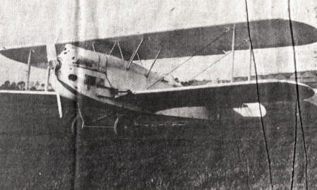
Did you
know that on May 9, 1927 a French biplane flew over Alexander,
Cooper and Crawford before disappearing? That plane had just crossed
the Atlantic from East to West flown by two French pilots. The plane
was named White Bird and its wreckage has been sought for decades to
prove that it actually reached North America.
Harold
Vining [1908 – 1990] told his memory of the event to Clayton Beal
who put the story into the May 6 1987 issue of the Bangor Daily
News. Harold lived in the southwest corner of Cooper on the road
that bears his family name. At that time a group called The
International Group for Historic Aircraft Research [TIGHAR] was busy
searching the woods south of Cooper for the plane’s engine.
Jim Reed
of Vinalhaven had come across an airplane engine while hunting in
this area during 1970. Reed was a mechanic for the Air Force and
later for Pan American Airlines. He was familiar with engines.
Evelyn
Magoon and her parents lived on the Lydic Set-off in Crawford. That
property was once in Alexander but since April 2, 1859 has been in
Crawford and bounded on three sides by Alexander. Evelyn remembered
that day in 1927 when the airplane circled her house twice in
unsettled weather before heading toward Love Lake. Evelyn [1917 –
2004] married Philip Sharpe and was living in Augusta when she told
her memories.
A-CHS
still collects information, organizes it and publishes through our
web site. We welcome queries. And we’d welcome more memories of the
White Bird from children or grandchildren of the 1927 observers. By
the way, Charles Lindbergh landed in Paris on May 21, 1927 after a
3010 mile, 33½ hour trip, the first documented Trans-Atlantic
flight.
WAR OF 1812
November 13, 2014
Did you know that THE BRITISH ARE
COMING? This was headlined in the Calais Advertiser of July 3, 2014.
There was great concern in Eastport that the British would attack
their village on Moose Island. Fort Sullivan in Eastport was built
in 1808 for their defense. The War of 1812 commenced in that year,
but did not get to eastern Maine until 1814. That is when the
British did come and captured or controlled Moose Island and the
entire coast west to the Penobscot River.
An order was issued on July 15,
1812 for the third regiment commanded by Lieutenant Colonel Oliver
Shead and a company of artillery to ‘repel any invasion of the
enemy’. Shead’s regiment consisted of seven companies. The Militia
was posted at the barracks off and on for the next two years. These
poorly trained and equipped men would have been no match against the
British.
Alexander probably sent no men to
Eastport; the nearest Militia Company was then in Calais. However a
few militia men at Eastport eventually settled in Alexander. They
were Annaniah Bohanon, William D. Crockett, Joseph Davis, Warren
Gilman, James Perkins, John Miner Sprague and Jesse Stephenson. Look
carefully at yourself and your neighbors. Two hundred years later
descendants of these early ‘defenders of our liberty’ are all around
us.
MY
REVOLUTIONARY WAR ANCESTOR
November 20, 2014
Did you
know that everyone has a family history? When I look at October on
the 2014 calendar, I see two dates that were important to my
ancestor Joseph Dudley. On October 17, 1777 he started the day in
British General John Burgoyne’s Army at Saratoga, New York. During
the day the American Army defeated the British and many of
Burgoyne’s conscripts went ‘over the hill’ and joined the Americans.
So at the end of October 17, 1777 Joseph Dudley and many others were
part of the American Army under General Benjamin Lincoln.
Joseph
stayed with this Army and on October 19, 1781 he was at Yorktown,
Virginia when British General Cornwallis capitulated to the
Americans and his sword was delivered to General Benjamin Lincoln.
Joseph had been in Lincoln’s Army four years and two days, but the
connection didn’t stop there.
In 1784
Benjamin Lincoln and two others purchased Townships 1 PS and 2 PS
[now Perry, Dennysville & Pembroke] and some of his former soldiers
bought farm lots from him. That is how Joseph Dudley came here and
why we find hundreds of his descendants who share this bit of family
history. This family history connects with Alexander history through
five generations of those descendants. Knowledge of our family
history just requires research.
A
BIRTH AND A DEATH
November 27, 2014
Did you
know that two hundred years ago two first-ever events happened in
what became our town of Alexander? The first event was a sad one.
That was the death of Mrs. Mary Young who died on April 18, 1814.
She was a sister of Amelia [Campbell] Bohannon [wife of Ananiah].
She was buried near the Bohanon homeplace, likely in the cemetery
east of the home site. She was of Calais; who was her husband? The
home mentioned was on Lot 65, west of the County Road and between
the Airline and Arm roads.
The first
recorded birth in Township 16 was Freeman Putnam Fenlason born on
June 4 1814. His parents were Mark and Sally [Ellsmore] Fenlason and
their home was on Breakneck Mountain. Freeman married Harriot Newell
Dunn on November 2, 1837. Reverend George Childs performed the
service. Harriet had grown up on a beautiful farm at 329 Arm Road.
Their children included Myra, Elvira, Charles [who fought in the
Civil War – see ACHS Newsletter for August 2011], Harris and
Francis. Harris was born in Crawford; the others were born in
Alexander. Do you descend from one of these children?
These events happened in
Township 16 BPPED that became the Town of Alexander in January 19,
1825. Shall we have a celebration on our 200th
incorporation day? BPPED stands for Bingham’s Penobscot Purchase
Eastern Division.
THE ERIE CANAL
December 11, 2014
Did you
know that the Erie Canal opened on October 26, 1825? Probably no one
in Alexander had heard the news or realized how that event would
affect our lives. We often need to read history of other places to
learn about what happened in our town. A Savannah, Georgia newspaper
reported in October 1826 that wheat grown in the Mohawk Valley of
New York could be acquired for less that Georgia grown wheat. Why
was that?
One must
realize that the Erie Canal followed the Mohawk River and that most
grain in New York was grown within one mile of the river. Also that
the Mohawk flows into the Hudson River that flows to New York City
where ships loaded with grain could depart for Savannah or even
Portland, Maine or East Machias, Maine. The cost of transportation
is an important part of what we pay for products we need or want. So
what does this have to do with Alexander?
Let’s
consider one neighborhood in Alexander. On October 26, 1825 seven
families lived on Breakneck Mountain on farms totaling 1051 acres
according to deeds from Caleb Cary of East Machias. These families
were headed by Michael Noddin, Ebenezer Gooch, Mark and Samuel
Fenlason and by the Babcock brothers, Stephen, Gideon and John.
Seven men, seven wives plus 53 eventual children equals a population
of 71.
The first
need of these settlers was to feed and clothe their families and to
provide a warm home in winter. The land and their labor were all
they had to fill these needs. Their need for cash was satisfied by
cutting pine logs on their farms and driving them from Barrows Lake
down the East Machias River to the mills at East Machias Village.
But soon the easily to harvest pines were gone and these farmers,
like so many others, turned again to their land to provide another
cash crop – grain.
Everyone
needs to eat. Imagine growing fifty bushels of wheat, harvesting and
threshing it, then loading it on your wagon. Imagine the feeling
when arriving at East Machias and finding out that New York grain
was selling in the coastal towns for less money than your Alexander
grown grain.
Breakneck
Mountain today is mostly forested with one huge blueberry field, a
few cellars, but no residents. The Erie Canal is part of the reason
no one lives there. Where did they all go?
ERIE CANAL #2
December 18, 2014
Where did
those families who had lived on Breakneck go? The bigger question is
where did people from Alexander and Crawford go? The answer is to
all points of the compass. Some who went west may have used the Erie
Canal. Here are three of those who left.
Mary
Amanda Tyler [1828 – 1885] and her brothers Daniel [1817 - ] and
Robert [1822 - ] went west to California. On this overland journey
they encountered many dangers including numerous threats of Indian
attacks. She arrived in Stockton CA in November 1853 and immediately
married Josiah Hanscom [1822 - ].
Josiah was
from East Machias, but had been teaching in Crawford immediately
before his 1850 departure west. He sailed around Cape Horn on the
California Packet and went into raising livestock and growing wheat.
He and Mary had seven children.
Here is a question about Mary we can’t answer.
Did Mary shave her head before heading west? Many young women did.
Travel by ship, train or wagon train left little opportunity to keep
the hair clean and bug free. Lice were more common then. For travel
by wagon train, an added threat existed. Plains’ Indians needed to
maintain or grow their populations if they were to rid the plains of
white invaders. One way to do this was to kidnap white women. These
women would become part of the tribes and mothers of Indian
warriors. Our newspapers report this activity is still happening
elsewhere in the world.
Charles
Otis Carlow went west to Wesley. Otis [1909 - 1994] was a
farmer, woodsman and the man who kept order at the Wesley dances. He
married Georgia Seavey of Crawford. Their son Richard moved back
home after years in the Air Force and his brother Paul chose to live
in Maryland. Otis has several relatives here in Alexander including
one of our selectmen.
William
Valentine Davis moved north to Danforth. As you remember he was
living at his grandparents Crockett house with his wife Lucy Bird
and two sons. In May 1863 Lucy gave birth to a girl; in June Lucy
was dead and buried south of the house. As often happened, Lucy’s
sister (Matilda) took her place. They married in March 1866. The
blended family appears next in official records in Danforth,
Washington County’s northern most town.
The Erie
Canal was just one of the causes for the drop in population of our
area. Alexander and Crawford reached their peak populations in 1850
(544 and 324 respectively). Cooper had its greatest number in 1840
(657). Our State of Maine had steady growth from 1820 except for the
decade that included the Civil War. Some in my Lane family went to
Minnesota for better farm land. Why did your family members leave?
22nd
REGIMENT MAINE VOLUNTEERS'
February 2, 2015
Did you know why twenty men from Alexander,
Crawford and Cooper all went to Dr. Job Holmes in Calais in
September 1862? The reason was so they could have physical
examinations to see if they were fit for service in the Army. Who
were those men?
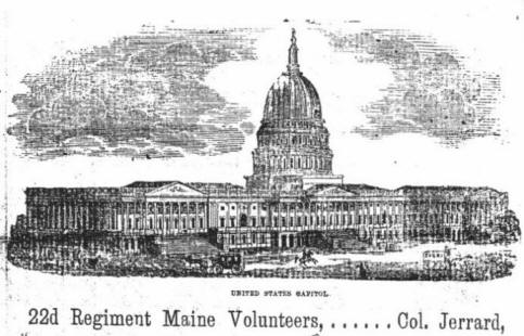
Image from The 22nd
Maine Volunteer Infantry in the Civil War by Ned Smith.
From Crawford we had Stillman Bailey, Watson
Lowe, Isaac Niddin and Daniel Perkins. From Cooper were Henry
Burbank, Isaiah Foster, Charles Hayward, brothers Benjamin and Levi
Henderson, Hiram Hitchings, Francis Lane, George W. Smith and
William H. H. Waterhouse. Those from Alexander were Jones Brown,
William H. Brown, William H. Crafts, Peter C. Lamb, Greenwood Lyons,
John Munson, Samuel Seamans and Jefferson Spearin.
All these men ended up in
Company F of the 22nd
Maine except for Jones Brown [Co H, 28th
Maine], George W. Smith [Co H, 16th
Maine] and William Waterhouse [Co H, 28th
Maine]. Dr. Holmes rejected Isaiah Foster from military service.
Young men moved about
frequently. Peter Lamb was a land surveyor working in Alexander at
the time. He was a Sergeant in Co. F, 22nd
from Calais according to Maine Adjutant General’s Reports. Jones
Brown apparently was from Big Lake Township and George W. Smith from
Jonesport and later Princeton.
Ned Smith recently wrote
The 22nd
Maine Volunteer Infantry in the Civil War. It includes a history
of the regiment’s activities and a roster of the men who served.
You might be curious about
the three “William H.” listed. William Henry Harrison was a son of a
signer of the Declaration of Independence (Benjamin Harrison). Wm H.
was also a popular general known as ‘Tippy Canoe’ who made the
Northwest Territory safe for settlement (via the Erie Canal). And,
remember ‘Tippy Canoe and Tyler, too’, he
was our ninth president. He
was inaugurated on March 4, 1841, caught a cold, and died on April
4, 1841. Many male children born thereafter in Whig families carried
his name. Harrison’s grandson, another Benjamin, became our 23rd
President.
GHOSTS
February 19, 2015
Did you know that Hazel Frost told of a ghost
living in her house? That story was recorded on September 9, 1980 on
tape 1 of A-CHS audio collection. Her house was at 73 Cooper Road
and known as the Townsend House after its builder. Who was that
ghost? A recent conversation suggested that it was the ghost of a
woman who had been hanged as a witch! Who was that woman? Maybe
someone can tell the rest of that story.
Above we have the final image of the Townsend House. That was Town
Meeting Day,
March 31, 1990. What happened to the ghost?
We know more about the ghost on Gooch Hill. Here
are words of Jack Dudley telling the story of that ghost at an A-CHS
meeting on May 5, 1981.
"Merle
Knowles told me this story, that there was this peddler. He did not
have
a horse
and wagon. He was walking - pack on his back - and he sold jewelry
and watches and things like that, small stuff. And, it was getting
along toward dark and he was headed towards Cooper and he stopped
over there at the foot of the hill at Stephenson's, and knocked on
the door and wanted to know if they would put him up for the night.
And, Stephenson told him, no, they did not do that, but up on the
top of the hill where Gooch lived, that Gooch - there was no
question about it that he could spend the night there. So, he
departed. And, the next thing, a week or two or three later, the
peddler was found dead with his throat cut in the well up there
somewhere near the Gooch place with no money, no pack, no nothing.”
Ethel
McArthur said, "That's why the house is haunted, The story that I
got was that Mrs. Gooch, when she got real old and somewhat senile,
used to remark, "What would you think if you saw two men go down
cellar and only one come up?" I never knew that the body was
discovered. I assumed it was still in the basement."
Jack
Dudley continued the story: "Rowena Bates bought the house. They
used to live over there, she and her husband. This room in the
house, they couldn't keep the door shut. They even tried to tie it
with a rope, and then it would be found open. And, they finally must
have heard of this story, and they figured the house was haunted and
subsequently the house was torn down and they built a new one."
Pliney
Frost added that the original house was the same one where John F.
Sullivan, who was hung for the Dutcher murders, was arrested. The
original house was owned by J. Gooch from 1861 to 1881 when it was
sold to W. Gillespie; sold in 1900 to Herbert Perkins; sold to his
daughter and son in law, Leota and Les Worrell; then to Ed Sullivan;
then to Frank and Bertha Dwelley, and to Everett and Rowena Bates
about 1960.
BROWNFIELDS
February 12, 2015
Did you
know that the National Geographic Magazine for December had
an article about Superfund sites? It did not mention the one near
Alexander. This article prompted a discussion about potential
polluted sites here. Sites with soil and water polluted so that we
cannot use them are called brownfields.
We
concluded that we might have three potential brownfield sites in
Alexander. The first created was at the northeast corner of the
South Princeton Road and Airline. This once had a salt shed for ice
control on roads. The second is north of the Airline on
Wapsaconhagan Hill. It too was the site of a sand-salt shed and was
torn down by the town in 1968. We know that salt is consumed by all
of us, but, like chocolate, too much salt isn’t good for us.
The third
brownfield site likely is the closed and capped dumpsite on the
Spearin Road. We threw our trash there from 1965 to the early 1990s.
During that time our trash contained chemicals that are poisonous,
but, we as a society didn’t realize how bad they are for the
environment and those of us who live in our environment. Those
chemicals mostly were the result of research done during WWII.
Before the town dump opened, most of us, and we were not too
numerous then, threw our trash over a rock wall or into an old
cellar. And that trash contained few contaminants.
Are there
other brownfield sites in Alexander or in Crawford? How many of us
have some fluid leaking from our truck? How long will it be before
that fluid reaches our well? Who will drink the water?
Oh, the superfund site near here is the five-acre Eastern Surplus
Company site by the Dennys River in Meddybemps. The EPA started the
clean-up in 1999 and found Indian artifacts on the site. The
Passamaquody call the place Ntolonapemk.
Some of
the pollutants listed in the Geographic article come from fumigants
to control insects and rodents, pesticides, organic compounds [ie
petroleum products], PCBs, vinyl chloride, methane, and metals such
as copper, arsenic, lead, zinc, aluminum, mercury and iron.
GLACIERS
March 5, 2015
Did you know that Alexander-Crawford history is
based on things that happened thousands and millions of years ago?
Off our coast are remains of ancient volcanoes and on land in Maine
are mountains that are granite batholiths that were pushed up
millions of years ago. We have granite under our area, but not
visible in most places.
What is
visible is stuff placed here by the glaciers; that happened just
thousands of years ago. And it is this stuff that has affected our
history and our present time. The glaciers formed the great north to
south ridges that our settler families chose for their home sites.
Look at
the two published maps, Wallings’ 1861 Map of Washington County and
George Colby’s 1881 Atlas. Both mark dwellings with names of
occupants. Farmers knew that the soil on ridges was better than in
the lowland. Most roads were built to connect homes, and also
followed ridges
Depressions left by the last glacier filled with water and became
lakes. Barrows, Pleasant and the two Mud lakes plus parts of
Meddybemps and Pocomoonshine lakes are in Alexander; Crawford Lake
and part of Love Lake are in Crawford. Once the site of wooded
shorelines, fishing camps, then summer homes, today we find
year-round homes on most of these shores.
Streams
within glaciers carried sand and gravel from places north of here.
This material was deposited as gravel hills like the Alexander
Cemetery, swaths like the Flat Road and sites of gravel mines (open
pits). The glacier also brought boulders and left them scattered on
our land. These are erratics and some are as big as a truck. Once
you have seen the results of the glacier near home, you can find
other glacial evidence elsewhere.
Harold
Borns of the University of Maine has created the Down East Ice Age
Trail that has about 50 places between here and the Penobscot River
where one can see results of our glacial past. The map is available
on line or at the Information Bureau in Calais. The Whaleback in
Aurora is one of those sites.
SETTLERS’ ROAD
March 12, 2015
Did you know that a popular hunting area in
Alexander is a road with a story? Most of us have seen that road
that starts at 986 Airline Road, just across from Gary Howland’s
home. It was the site of a major logging operation this past year.
This woods road follows an old settlers’ road. There were five homes
along that road; sites have been found and we have GPS readings for
all thanks to Dale Holst.
Site 1 is
at the intersection of the Airline. Census records for 1850 indicate
that Richard Libby [born 1821] was the first to live there. His half
brother John Gray [born 1817] followed him according to the 1861
map. Their mother was Sarah Caldwell Gray Libby who lived where Gary
now lives. The final resident was their nephew Asa Libby Berry [1850
– 1923].
Site 2 is
a quarter mile to the south on the west side. Ephraim Scott [born
1809] of Baileyville his wife Ann Bailey and their seven children
were here just for the 1850 census. The fine stone work was done by
stone mason Samuel Berry [1811 - 1870]. He and his wife, Cordelia
Jewett Gray [sister of John at site 1], and eight children were here
from the mid 50s. Cordelia and son Asa lived at the site until after
1880, then moved to site 1 before 1900.
Site 3,
also on the west side of the road, had just one family of record
there. It was Ebenezer Brown [born 1819] with his wife and one
child. The family from New Brunswick was there only for the 1850
census
Site 4, on
the west side of the road is near a huge oak tree. One family of
several generations resided here. That was the Knight Family,
spelled Night by one census taker. James Dyer Knight [born 1806] was
the first being here by 1839 for over a decade. Stillman Paul Knight
[born 1829] lived here from the 1850s into the 1880s. His wife
Lavina Averill [1835 - 1874] is buried at the Alexander Cemetery.
Site 5 is
known to many as the Nellie Berry [1862 - 1955] Place. The house sat
at the south end of this road, which swung westerly to meet the Flat
Road. Nellie was a Munson; her husband was Edgar Berry who we cannot
connect to the other Berry family. Abiel Abbott [born 1795] may have
been the first ca 1850 to live here followed by Tom Carter [born
1830] and his family. Tom was an Irish immigrant and was here from
before 1870 to after 1880.
The land
[part of lots 61, 72& 129] belongs to Carleton Brown. The land has
been in his family since before 1860 when Samuel Berry arrived from
St Stephen. Samuel was Carleton’s great great-grandfather. On
another line his great great-grandmother was Rebecca Knight who
married Michael Brown.
MEMORIES OF MAINE
March 19, 2015

Did you
know that a painting of an Alexander home appeared on the front
cover of MEMORIES OF MAINE, summer 2014 edition? Local artist John
Foley painted the picture of Lewis Frost’s house as part of a series
he did of historic buildings. Few recognized the building painted
from the orchard, not the Airline Road. The painting also is
featured on the title page of the A-CHS web site.
David
Branch, publisher and editor of the magazine used an article that
gives an overview of Alexander’s history. That article was prepared
by John Foley and John Dudley while part of the committee that drew
up the Alexander Comprehensive Plan. That plan was done in 2005 and
is, in its entirety, on the web under wccog.net/ community
planning/ alexander
Branch chose five pictures to accompany the
article that starts on page 12, including another view of the same
house found on the cover. The article covers our history from its
1786 delineation to the development of lake shore homes within the
past twenty years.
Did you
know that the Alexander – Crawford Historical Society has no moving
pictures in its Archives? We’re speaking of home movies shot mostly
after WWII on 8 or 16-millimeter cameras or later on moving images
caught on VCRs. Many of us remember someone with a camera at the
Independence Day parade or at a picnic or birthday.
These
silent films are part of family history and town history. I’m told
that Wal-Mart can copy the film content onto a compact disk and
return the film undamaged. The digital form can be reproduced on
other CDs to share, saved on a computer, and a copy can be used by
A-CHS on our web site <mainething.com/alexander>. Call John
[454-7476] if you have an old home movie to share. That is the first
step in making that film part of the recorded history of Alexander
or Crawford or Cooper.
CLINTON FLOOD
March 26, 2015
Did you
know that 1926 was a year of change for Clinton Flood? His father
Frank died in November. That was just two months after Clinton and
Doris “Duffy” Harriman had married [September 18]. They moved to the
family farm [lot 59 where Lawrence Lord’s Museum now stands] and
using Frank’s 1917 Model T Ford and horses started farming.
Clinton raised potatoes and vegetables to
‘peddle’ in town on Tuesdays. They milked cows and sold butter as
well. He cut wood in the winter and hauled it by horses and sleds to
Woodland. He used a well-known road that followed the meadows along
Wapsconhagan Stream. In 1928 Clinton bought a new truck, GMC, and
sold wood through Gene Hatt, two and half cords per load.
Clinton had dairy cattle. After selling butter,
he sold cream to Hancock County Creamery in Ellsworth. He, Lyston
Frost and others took the cream in 5-gallon cans to the train in
Calais. Later he sold milk to Schoppees’ Dairy in Machias and
finally to Grants. He quit when Grants wanted a bulk tank for milk
at his farm. He raised starter calves after that.
Clinton continued to use horses on the farm. He
traded horses in St. Stephen at Frank Hall’s Stable and forgot to
report the new horse on his way home. The trade would cost Clinton
as much as $300. He bought his first and only tractor in 1963. The
new bailer cost $500; he sold it in 1985 for $700. Clinton took good
care of his equipment, always stored it undercover in the cellar of
his barn. Why did the barn have a cellar? Were there others in our
area? The barn was built ca 1868 by Jefferson Spearin after he came
back from the Civil War.
This information came from a taped interview of
Clinton by John Dudley in December 1985. Back to that marriage. In
1903 Fred Harriman, Jr. lived where Joey and BJ. Wallace now live.
Soon after his wife Jennie had born a little daughter, Fred Harriman
while visiting Frank and Ella Flood stated, “We have a brand new
little girl for your Clinton.” And Clinton’s eyes were sparkling as
he told that story.
Clinton mentioned Verne and Flora Perkins. They
lived where we find Weibley Dean is today at the corner of the
Spearin and Flat roads. Charlie White told me that Verne milked
Jersey cows and sold the cream to Jane Todd in Calais. She had a
candy and ice cream shop on Main Street. Verne was a slow and
cautious driver, always honked the car horn when approaching a bad
corner.
POKEY DAM
April 2, 2015
Did you know that the new fishway at Pokey Dam in
Crawford was completed this past fall? Planning for the project
started several years earlier when the Crawford Pocomoonshine
Watershed Association realized the old wooden fishway needed to be
replaced. The Downeast Salmon Federation, that has a fish hatchery
in East Machias, also became aware of the problem.
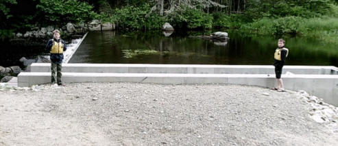
Dam on left, new fishway &
Jones Boys after looking foe alewives.
DSF
members met with CPWA President Coburn Wallace and some of the board
members at the site in 2012 and a coordinated effort started that
involved seven groups. Funding for the $99,000 project came from
thirteen sources. With the fishway in place, alewives, eels and
maybe Atlantic Salmon will have access Crawford Lake, Lower and
Upper Mud lakes as well as Pocomoonshine Lake.
There was
a river-driving dam at the site before 1851 according to John
Springer in his book FOREST LIFE AND FOREST TREES. The last drive
down the East Machias River was in 1919 according to Harvey Hayward.
About 1925 Bangor Hydro Electric built a storage dam that could hold
water three feet higher than present levels. They generated power at
the site in East Machias where Downeast Salmon Federation is today.
That high
dam was burned in 1934 and in 1936 a roll dam was built there by
Frank Magoon, John M. Dudley and Conrad and Perley Woodruff.
Dudley’s interest was wildlife habitat and the other three needed a
dam for their eel trapping. The Maine Fish and Game Department
rebuilt that dam and fishway ca 1955. Thirty years later the
watershed association was created and was given ownership of the dam
by GP. Locals worked hard to make a concrete dam and the wooden
fishway was rebuilt. The new fishway is concrete and aluminum.
Before ca
1895 when Fred Harriman and Frank Averill hauled barrels of pickerel
here from Big Lake, white perch and square tailed trout were the
game fish of the four lakes. The pickerel were fished commercially
here until the mid 1930s. With no dam ca 1935 small mouth bass
arrived. The large mouth bass arrived in 1987 either accidentally or
intentionally planted at the head of Pocomoonshine Lake.
GOLD MINE
April 9, 2015
Did you know that over a hundred years ago a mine
here in Alexander produced gold? In 1901 Fred Hall of Calais blasted
a 35-foot deep shaft on lot 68. No written record was found about
what he got from his mine, but he left behind rubble that tells us
what was under the ground there.
The site
was vacant until 1955 when a Forsyth man did a preliminary survey of
parts of Alexander. His maps were of a scale that proved to be of no
use. In 1962 the state studied the mine dumps and determined metals
present. Copper, sulfur, iron, zinc, silver and gold were found plus
nickel at three times the rate of cobalt. This high rate of nickel
attracted Peter Ferderber of Quebec who in 1963 entered into legal
agreements with landowners to explore the area. He used a power
drill with an auger that would extract cores of the bedrock.
Apparently the deposit of high grade nickel was too small to justify
mining; at least with world prices of nickel what they were then.
A rumor at
the time was that a deposit of high grade nickel had been found out
back of St. Stephen, but the Alexander deposit was not connected to
it. The St. Stephen nickel is still in the ground.
Before you
grab your shovel, remember we have two kinds of gold under our feet.
Some is within the under lying igneous rock [granite]. The second
source of gold is in the material placed here by the glacier. Gold
is one of the most wide spread metals in the world, but is scattered
so thinly that it usually costs more to mine than it is worth. The
gold on lot 68 measured at about 5 thousandths of an ounce for a ton
of rock.
Mining is
a very competitive business. Peter Ferderber requested the local men
who worked for him to keep their lips sealed. Except for the rumor
above, everything else here is from public record. After 50 years we
find that Charlie White used his truck to move Ferderber’s equipment
from and back to New Brunswick and around this area. Harold Dwelley
used his bulldozer to move the equipment on soft ground down near
Sixteenth Stream. Are there other names we can add to the story?
Call John at 454-7476
FOREST FIRE
April 16, 2015
It was hot
and dry on May 25, 1966. Kids at the schoolhouse at the corner of
the Arm and Cooper roads probably were wishing they were
out-of-doors. Among those children were siblings Mark, Mike, Linda,
Sherry and Rhonda Magoon. Bonnie Lord was there with her sister
Barbara and brother Terry. Barbara, Frank and Mary Williams were
there from just up the road. And from the Davis family we had
Norman, Joanne and David and their stepbrother Paul. One of these
families was about to experience a tragedy.
[Where did
I get these names? <www.mainething.com/alexander>. Go to Alexander
History, to Community Life, then Education – Alexander School 1965 –
1966]
Meanwhile,
up the road, the sun shining through a piece of glass ignited the
old dry grass. The nearby buildings caught afire and Rose Williams
saw the flames and tried to start the tractor in the garage. She was
burned before she had to give up. Her husband Lyman was in New
Hampshire and her son Calvin was in the Army and Donna was gone.
Like so many homes in those days, there was no phone. Someone
stopped at the school to call in the alarm. A teacher told Frankie
and his siblings that their house was on fire.
By the
time firemen from our local volunteer department arrived, the house
was fully involved and the fire had raced across the field and into
the woods, heading north for Route Nine. A forest fire alert was
sent out and crews came from all around. According to the 1966 – 67
Annual Report of Alexander fifty-three men were paid to fight the
forest fire. [The State helped pay for fighting forest fires, but
the volunteer firemen did not get paid to fight house fires] The men
fought the forest fire with Indian pump cans in Henderson Swamp and
Shay Meadow and along Meadow Brook. The fire was stopped and the
town was saved.
Some local
men on that list were Harold Dwelley, Carleton Davis, Everett
Dwelley, Raymond Flood, William Holst, Bernard Flood, Elbridge
McArthur, Lawrence Frost, Merle Knowles Jr, Russell Strout, Paul
Dwelley, Gerald Cooper, Roger Holst, Carleton Cooper, Herman
Wallace, Max Berry, Roger Craft, Carleton Davis Jr, Joel Craft,
Clinton Flood, Russell Flood, Justin Day, Ralph Flood, Walter
Morrisey, Lloyd Dwelley, Roy Carlow and Terry Holst. The total
payroll for the fire was $1075.91. The state reimbursed the town
$532.96.
What
happened to the Williams family? They spent that summer at Gordon
Lord’s camp on Pleasant Lake. In the fall of ’66 they moved to
Middle Ridge in Cooper. In 1977 the family moved back to Alexander,
to the Fred Niles Place on the Arm Road where Rose had grown up. A
forest fire also burned in Baring on May 25, 1966. Family memories
helped with this story, as did a front-page article with picture in
the Calais Advertiser.
TITANIC
April 16, 2015
Did you
know that natural resources and landform usually drive the economy
of a place and are responsible for part of its history? Alexander
has some decent farmland, lots of forests and several lakes. All
these are the basis for our history. One thing we don’t have is
black granite and so our connection to a famous marine accident is
slim.
The
Titanic hit an iceberg and sank on April 15, 1912. One thousand-
five hundred and seventeen people died. Of those three hundred and
thirty-three bodies were recovered. Many of those bodies were taken
to Halifax and buried. At one large cemetery are about 150 identical
grave stones, all black granite. Where was the black granite
quarried?
Barrie
Clarke, adjunct professor of earth science at Dalhousie University
in Halifax, wanted to answer that question. He started the search in
2000 when the people of Halifax started to research their
relationship to that 1912 event. One stone was chipped and Barrie
got a small sample to analyze in the geology laboratory. He
determined that the sample was 422-million years old. And he
realized that the nearest source of granite that age was on either
side of the Saint Croix River.
All that
explains why Barrie Clarke showed up at my doorstep about ten years
ago. He thought the black granite quarry on Staples Mountain was in
Alexander. It is in Baileyville and records show that it was
inactive before 1912. That and a sample of the stone convinced
Barrie to look elsewhere.
Nine years
later and many, many trips to cemeteries and old quarries in the
area he found the match. The black granite from the Old Hanson
Quarry matched the black granite in the cemetery stones. The quarry
is off the Bocabec Ridge Road on Chickahominy Ridge near St.
Andrews.
What is
missing is historical evidence, newspaper reports, pictures with
people and place identified, diary entries, Hanson’s business
records, records from the stone finishing shed in Saint George or
freight papers. Were the stones taken from Saint George to Halifax
by boat or train? No historic records have yet been found!
Alexander’s connection to the Titanic is slim. What happened here on
April 15, 1912? What were members of your family doing when they
heard news of the Titanic? Alexander has many stories still untold.
Human memory, either first hand or passed down through generations,
plus some historical evidence will add to our story. Share your
story with Cassie!
ALEXANDER EAGLES BASEBALL TEAM
October 29, 2015
Did you know that area men once
played baseball for fun and women and children watched the games
within the real world? In the 1930s the Alexander Eagles home field
was at the Four Corners, where the Airline and South Princeton roads
intersect. (It is a blueberry field today.) According to Marian (Dwelley)
Cousins some of the players in those early days of the Depression
were Ronald Cousins and his brother Orris, Donald Frost and his
brother Lyston, Lewis Carlow and his brother Otis, Bert Varnum and
Neil McArthur.
For a couple of years the team
played on a field across from the Grange Hall while the field at
Four Corners was rebuilt, probably just after the war. The temporary
field was on Lyston Frost’s farm.
Arlene Perkins McArthur kept
the OFFICIAL BASEBALL SCORE BOOK and it is now in the ACHS archives.
This book has records of numerous games played, some with month, day
and on one place the year 1950. Probably the entire record book was
for 1950. Some of the teams played were from Robbinston, Calais,
Milltown and Woodland.
On two separate papers we
find a list of names with ‘at bats’ and ‘hits’ and for most the
batting average. Ken Varnum– 590 (1st
base), George Kneeland – 430, Carroll McArthur – 390 (pitcher), Neal
Seavey – 500 (first & left field), Bill Holst – 500 (catcher), Alva
Cousins – 410 (center field), Elbridge McArthur – 370 (2nd
base), Bob Allen – 235 (3rd
base), Sherman Flood – 335, Calvin White – 335, Lawrence Frost – 500
(short stop), Shirley Hunnewell – 335 (pitcher), Bucanan – 570, Nash
– 420, George Dwelley – 310, Carl Perkins – 200, Charlie Frost, ( )
Patten and ( ) Morrisey. Ted Williams was not listed in this
material.
Calvin White gave the positions commonly played
by the above players, shown in (parentheses). Two names Calvin
mentioned that were not on the list are Lyston Frost – 3rd
base, and Darrell Frost – right field & 3rd base.
This being World Series time, one might realize
that in the 1930s radios were fairly rare here and battery operated.
By 1950, most homes had electricity and an electric radio.
Who were Patten, Morrisey,
Nash and Bucanan?
APPLE TREES
November 5, 2015
Did you know that once upon a
time apples were grown in Alexander and in most New England towns? I
found out last spring when I planted two special named apple trees,
one an Alexander and the other a Dudley. You can easily guess why I
picked trees with those two names.
I looked in Apples of
Maine by Frederick Bradford [1911] at the University of Maine.
I learned that in 1847
Browning and Queen’s Pocket apples were harvested here in Alexander.
However those apples were not suitable for the winter export market.
The following year Baldwin apples
were harvested here. They were good for winter export. In 1856 the
Maine Pomological Society recommended the Baldwin for use throughout
Maine. It became the leading variety of apples in Maine twenty years
later and as late as 1925 represented 32% of commercial orchard
trees in the state.
In 1740 John Ball first found
what we call the Baldwin apple growing wild on his farm in
Wilmington, Massachusetts. Later Revolutionary War soldier Loammi
Baldwin found like trees growing along the route of the Middlesex
Canal. It was his name that is attached to this fine apple tree.
Baldwin seedlings were sold by a nursery in South Orrington,
Massachusetts starting in 1813. Of course South Orrington became
part of Maine in 1820 and this nursery likely supplied the trees
planted in Alexander.
It was in May 1934 when we
had several hot, hot days followed by an extremely cold night, The
cold froze the sap filled trees, killing 2/3 of the Baldwins in New
England; over a million trees! Thus ended an important Maine and
local agricultural industry.
The Alexander apple was not
named for the town or for our namesake, Alexander Baring. It was
named for a Russian where the variety was established. It was
brought to Maine about 1830 from England. The Alexander is a
hardy-cooking apple, but requires careful handling to prevent
bruising.
The Dudley is a Maine apple
bred by J. W. Dudley of Castle Hill. He started with a Duchess of
Oldenberg apple and crossbred until he had a good fall apple, a good
keeper until mid winter. I hope it will be a good pie apple
Now is the time to put
predator guards around young fruit trees. If mice or voles gnaw the
bark from your trees, they will die; and dead trees produce no
apples.
Below is pictured a Dudley Winter Apple drawn by
John Bunker who is active in Maine
Organic Farmers and Gardeners Association and
Maine’s leading old apple expert.

ALEXANDER’S COMPREHENSIVE PLAN
November 12, 2015
Did you know that ten years
ago a group of Alexander citizens met to make a plan for Alexander’s
future? An alphabetical list of those attending reads: Ed Burgess,
Foster Carlow, Pedro Ceijas, Jimmy Davis, Charlie Dix, John Dudley,
John Foley, Audrey Frost, Dedi Greenlaw, Robert Hazelwood, Earl &
Patsy Hill, Roger Holst, Laura Jean Lord, Joe Manza, Kelly
McDonough, David McVicar, Roland Paegle, Tim Sanford, David Sullivan
and Charlie White.
Roger Holst was the chair and
Judy East of Washington County Council of Governments was the
consultant. Over thirty people attended an open meeting on November
29, 1994 and were involved in a visioning session. Where individuals
lived and worked was recorded on maps and lists were made of what we
liked about our natural environment and our man made environment.
Next followed meetings where discussions were aimed at specific
subjects and, among other things, general goals were established for
Alexander.
History Goal; We will
preserve historic and archeological resources.
Population Goal: We will use
current population information when making administrative decisions
and reports.
Natural Resource Goal: We
will protect and preserve the natural resources on which our economy
and quality of life depend
Economic Goal: We will
support existing local businesses and promote new businesses that
are compatible with our existing rural community values.
Housing Goal: We will
encourage and promote affordable decent housing opportunities for
our residents.
Recreation Goal: We will
maintain and improve access to recreational areas especially water
access.
Transportation Goal: We will encourage, promote
and develop efficient and safe transportation facilities for the
future.
Public Facilities and
Services Goal: We will plan for, finance and develop an efficient
system of public facilities and services. [administration,
utilities, highways, EMS, education, communications, health care and
cultural events]
Fiscal Capacity Goal: We will
manage our public funds and implement a capital improvement program.
Land Use Goal: We will
preserve and protect the character of the town that is vital to the
stability of the local economy and our life style.
Plans of the past may affect
us today. Decisions of the past do affect us now. Decisions made
today affect our future. Do you agree? See the entire Comprehensive
Plan at <www. wccog.net/community planning/alexander>.
It is full of ideas and has
many grafts and maps.
STEPHEN DECATUR FROST
November 19, 2015
Do you know where Stephen
Decatur Frost got his middle name? Stephen was a son of Jeremiah
Frost, Junior and Sally Thompson, the fifth of thirteen children.
The first three were born in Machias, home town of Sally. Child four
was born in TWP #7, now Baileyville. Stephen and the next three were
born in Calais. The next was born in Plantation 16 and the last four
were born in Alexander, actually in the same house! Stephen Decatur
Frost was born on November 20 1815.
We recently wrote about Jeremiah Frost’s early
house site and family cemetery on the original east-west road
through Alexander. Even though there are no gravestone inscriptions
at the little cemetery, it is likely children Joseph (1824 – 1824),
and Susan (1826 – 1827) are buried there plus, according to
historian Pliney Frost, both of their parents. I believe Jeremiah
Frost, Senior (1744 – 1820) is buried here because Alexander Vital
Records tell us that he died in Alexander; where else?
Stephen Decatur Frost came to
Alexander with his family ca 1824 and lived the rest of his life on
the homestead which is the east half of lot #66. He married Mary Ann
Bean on January 9, 1840 and they were the parents of a dozen
children. The first, a daughter, died in infancy. Next was Thomas
Bean (1841 – 1914) who married Emmaline Johnson; they were Pliney
Frost’s great grandparents.
Next came Augustus Wellington
(1843 - 1916) married Josephine Quimby, Dresden Diploma (1845 -
1863) was single, Stephen Decatur (1848 - 1923) married Louise Lane,
Chancey (1850 - 1872) was single, Enos Moore (1855 - 1920) married
Estella Bridges, Abner Sawyer (1857 - 1892) was single, Horace E.
(1859 - 1923) married Alice Smith, Charles Townsend (1862 - 1863),
Frank L. (1864 - 1867) and Harry E (1867 - 1926) married Eda Maud
Perkins.
That long list gives lots of
information and questions. Eleven sons equals four who married,
fathered children and lived here. Five sons were single. Stephen
moved to Vienna and Horace to Norridgewock. Where did their middle
names come from? How many readers are descendants of Stephen and
Mary Ann? How many are related through the spouses of descendants?
Who today carries that name – Decatur?
Stephen Decatur was a
privateer in the American Revolutionary War. His son Stephen was
born in 1779. He became a hero in our Navy fighting the Barbary
pirates and in the War of 1812. He died in a duel of honor in 1820.
Three cities carry his name (Alabama, Georgia and Illinois) and his
name is found in a long time family of Alexander.
LEVI HENDERSON WITH NO GRAVE STONE
November 26, 2015
Did you know the connection
between Levi Henderson and Barack Obama? Our Alexander news column
carried the May 2015 story of the dedication of a gravestone for
Levi. ACHS had acquired information from the government archives to
get Levi’s stone from the Department of Veterans Affairs. Foster
Carlow and Pat Cornier placed the stone at the Henderson lot in our
cemetery. The news column mentioned the dozen descendants who
attended the ceremony.
In June an important looking
envelope arrived that contained a certificate that stated: “The
United States of America honors the memory of Levi Henderson – This
certificate is awarded by a grateful nation in recognition of
devoted and selfless consecration to the service of our country in
the Armed Forces of the United States. (signed) Barack Obama,
President of the United States”
Another more interesting
connection here is that one result of the Civil War in which Levi
fought was the freeing of the slaves, African American slaves. All
the Union soldiers and sailors were part of this action along with
preserving the Union. Barack Obama did not descend from slaves; his
father was an African from Kenya. However, it is a neat connection
that an African American can serve as President today because Levi
Henderson and so many others fought between 1861 and 1865.
Levi Henderson did not have a
gravestone. He had died in Calais, likely at the home of his
daughter Eva May Bowles
Did you know that many are
buried at the Alexander Cemetery with no headstones? What are their
names? What lot are they buried in? What year did they die? Will
knowing the answers be important to some family member in 60 or 100
years?
ACHS member Sharon Howland
went fishing for this information twenty-five years ago. She
searched back issues of the Calais Advertiser and the Scholl Funeral
Home records. She made a list of thirty-five names buried at the
Alexander Cemetery, but not named on stones. That list is posted at
Randy’s and the town office. If you can add to the list call John at
454-7476
ELI WHITNEY & THE WOMEN OF ALEXANDER
Dec. 3, 2015
Did you know the connections
between the women of Alexander and Eli Whitney? Not all the women,
but a few when he was in his nineties and most women in the past
century, including our lady readers. I thought of this connection
when I recently looked at my calendar and saw that Eli had been born
in December 8, 1765.
He was born in Westborough,
Massachusetts and as a young man started a successful business
making nails and small wares, which were hard to buy because of the
War. He graduated from Yale and found a job as a tutor in South
Carolina. There an attractive widow of a certain Revolutionary War
general asked him to solve a problem faced by plantation owners.
Cotton was not King on
southern plantations at that time. Lots of labor was required to
plant, cultivate and harvest a crop of cotton. But the same number
of slave hands could not pick the green seeds from the cotton even
during the entire off-season. This was the challenge for Eli
Whitney. Invent a machine that would clean the cotton quickly. By
1793 Whitney had a simple machine that did the job and could be
powered by hand, horse (on a treadmill0 or water.
He patented the cotton gin (cleaning engine) in
1794, but never made money on it. It was so simple that many men
copied it. However, his gin allowed more cotton to be grown, which
continued or expanded the use of slave labor. Cotton became King;
and slavery became an economic necessity in the south,
Now here are three
connections between Eli Whitney and Alexander women. First, slavery
was a driving issue in the Civil War. Alexander men went off to war
and the women alone took care of the family and farm. As a result of
the war, some women were widowed, some got husbands back who were
crippled, and some resumed life as before. Some women were even
poorer than before.
Second after 1880 we find
some young Alexander women moving to Calais and working in the
cotton mill in Milltown NB. As a result of the cotton mill, women
met (and sometimes married) men who were not their neighbors; they
saw a new way of life and shared that with their families back home.
Finally, the abundance of
factory made cotton clothing freed Alexander women from the spinning
wheel and loom. And what did the women do with all the free time
gained by factory made clothes? Some continued to stay home, but
soon many had to get jobs to afford the things they no longer made
at home. How many women work out side the home today?
WOMEN IN LEADERSHIP ROLES
December 10, 2015
Did you know that Matilda
Joslyn Gage, Elizabeth Cady Stanton and Susan Brownell Anthony all
have a connection to Alexander women? They were workers for women’s
suffrage. They all died before “the right to vote by citizens shall
not be denied on account of sex” became law in 1920, Maine’s
Centennial year.
Alexander women and Maine women had that
Nineteenth Amendment right before women elsewhere because of Maine’s
first in the nation primary election in September 1920. The right to
vote also gave women the opportunity to serve in public office.
One such Maine woman was
Margaret Chase Smith. She voted and served in public office as a
result of the Nineteenth Amendment She was born in Skowhegan on
December 14, 1897. (That date is what pointed to this article) She
married Clyde Smith, a Republican congressman from Maine and upon
his death she was appointed to the House in his place. She was then
elected by the voters of the Second District in 1940, 42, 44, and
1946. Next she was elected to the US Senate in 1948 and re-elected
in 1954, 1960 and 1966. Her name was placed for nomination for the
office of President in 1964. She was best known as the first
Republican senator to speak out against the activities if Senator
Joseph McCarthy. This was known as her Declaration of Conscience
Speech and was given on the Senate floor in June 1950.
Alexander women have taken the
opportunity to serve their community. In the past 30 years or so
Phyllis Archer served at Tax Collector and Treasurer, Deanne
Greenlaw, and Shirley McCall have served in the combined job of Tax
Assessor, Collector and Town \
Clerk. Christine Smith was Clerk
back in 1984. In 1992 the Planning Board had Pat Moreshead as a
member. Several women were Assessors, Deanne Greenlaw, Kathy Kubinak,
Norma Donahue, Karen Sears and Brenda Hunnewell. Only one woman was
a member of the Selectmen’s Committee, Karen Sears in 1995–6.
It may be because women feel
greater love and responsibility toward children or because they look
at life with the longer view; Whichever, many have served on the
School Committee: Linda McArthur, Emma Turner, Lisa Lord, Maxine
Seavey, Sherrie Parks, Brenda Harris, Rhonda Oakes, Esther Tozier,
Beverly Holst, Michelle Clark, Lisa Thompson, Audrey Frost, Carla
Jundt, Jan Sullivan, Patsy Hill, Rosa Subialdea, Linda Richardson
and Melonie Howard. Thank you all!
If any name is misspelled or if I
missed a name, we will not blame Cassie. Call John at 454-7476 and
pass on the correct information. Lists of elected and appointed
leaders of Alexander are on the web site.
OUR AIRLINE REALIGNED BEFORE 1829
December 17, 2015
Did you know why we today
find old cellars in a line south of the Airline, but not connected
by road? “The record shows that “in 1829 a committee surveyed a road
… that passes through Alexander”. This was the official ‘Airline’
road that existed in 1829. The surveyors recorded, “The inhabitants
of Alexander have opened and put in repair a road partly in line of
aforesaid road, but varying, and nearly parallel to said road for a
distance of about two miles avoiding hills and bad ground, avoiding
cultivated land and that no person had suffered damages in the
laying out of this new road.” This is the road we drive over today.
An 1839 Petition to the
Washington County Commissioners signed by John Gilman Taylor and 69
others requested that the county take over responsibility for the
“new road”. Taylor was Alexander’s first Clerk. The Commission
accepted their request and the new road became the official road.
Today as we drive easterly from Durlings Corner
in Crawford, past the town line and Whitneys’ Originals, we arrive
at the base of a hill. The original road went straight, but now we
curve toward the north to Mr. Ed’s Blueberry Shed. In the field
opposite the shed we see a pile of rocks with a hay rake on top,
That was Sam Scribner’s home site on the original road. His family
eventually built the yellow house next to the present Airline.
The next two sites
are on opposite sides of the Old County Road that runs south from
the Four Corners. About half mile east of Sam’s site is the site of
Ananiah Bohanon’s home and family cemetery. This site in a blueberry
field has been leveled. Fortunately its GPS location and stone
inscriptions have been recorded. A quarter mile east we see Solomon
Strout’s cellar. After the road was changed, he moved the house to
the new road where it stood until about 50 years ago.
Another quarter mile easterly we find Jeremiah
Frost’s cellar and family cemetery. This cemetery has only field
stones with no inscriptions. From here the old road meandered
easterly to the present day Cooper Road, intersecting close to the
Spearin Road. From this point the 1829 survey followed closely the
same route we travel today all the way to Route One.
That one of Alexander’s log schoolhouses stood
easterly of Mr., Ed’s indicates that the new road was in existence
when Mr. Barstoe was its teacher in 1822. We know about the school
and teacher from Ananiah Bohanon. Our road was named ‘Airline’
sometime after 1857.
ALEXANDER IN 1975
December 24, 2015
Do you know what life was like in
Alexander 40 years ago? And if you don’t, where can you find out?
First and easiest is to ask
someone. Marie and I spent our first summer in our barn at 216 Pokey
Road. I worked on the border and Marie kept a vegetable garden. Or
one can check the Calais Advertiser for Town News. From this source
we learn that Alexander had a celebration of our nation’s
bicentennial on August 14 and that Ruth Dwelley had created the
first written history of our town.
Town business is described in
the Annual Report. Dollars of those days don’t compare to dollars
today, but our town was full of people and some are listed as
serving the public. I’ll list some and put their jobs in
parenthesis. Pliney Frost (moderator & assessor), Judith McArthur
(Clerk, Registrar of Voters), Carleton Davis (Selectman), Fred
Wallace (Selectman, Assessor), Kenyon Smith (Selectman & Assessor),
and Phyllis Archer (Treasurer & Tax Collector). Tom Smith and Robert
McArthur were Constables, Rolla Archer was Fire Warden and the
Selectmen served as Overseers of the Poor and Road Commissioners.
Page 3 of the Report has the
special message, “Due to loss of records in Town Clerk’s fire,
anyone who has not registered since the fire must do before they
vote.” What was the date of that fire? Not only was that fire a
disaster to Judith McArthur and family, That fire destroyed many
town records dating from 1895.
Those who worked on the two Elections were
Marjorie Hunnewell, Madeline Flood, Joyce Frost, Mildred Holst,
Phyllis Archer, Judith McArthur, Fred Wallace and Carleton Davis.
Maine Asphalt Co. tarred 6/10
mile of Spearin Road where the dump was located. Patching tar and
other maintenance involved Merle Knowles, Sr. (truck and driver),
Lynn Wallace (back hoe, bulldozer & truck), Fred Wallace (truck),
Dukey Hunnewell (truck), Carleton Davis (tractor), Elbridge McArthur
(truck), Dyer Crosby (truck and loader), Norman Davis (tractor),
David Davis (chain saw) and Philip McArthur (grader operator). Some
of the men listed above were also drivers and or labors. Other
laborers were Pliney Frost, Chris Landry and Clinton Flood.
Staff at the school located
at the junction of the Arm and Cooper roads were Mr. LaRochelle. Ms.
Haley, Mrs. McArthur, Mrs. Holmes and Jim Archer. The Planning Board
issued 21 permits under the guidance of Douglas Hunnewell. At the
March 15, 1976, the town passed a Flood Hazard Building Ordinance.
HOW TREES CHANGED MAINE
December 31, 2015
Did you know the historical
importance of trees to the people of Maine? Did you know that
harvesting these trees resulted in population expansion and
industrial growth? As an area historian and tree farmer I find it
interesting to connect trees to people and our man made environment.
Our streams and rivers were
dammed because of trees. The original up and down pit saws depended
on man power. Rivers were dammed so that waterpower could run the
saws. Temporary dams were built on brooks and streams to help move
the logs from forest to mill. Where a natural waterway didn’t exist,
man built a sluice to move his logs. The first incorporated company
to own a sluice was the East Machias Sluice Co. that connected the
river to the mills Unity and Industry. How many logs from Alexander
and Crawford were sluiced to those mills?
The mill on Sixteenth Stream at the outlet of
Pleasant Lake was water powered. A dry sluice was built on Breakneck
Mountain to slide logs to Barrows Lake from where they were driven
to mills at East Machias. A dam was built across Dead Stream between
Burnt Barn Hill and Breakneck to cause water to flow towards the
Dennys River and the mills of Dennysville. The first known mill in
Crawford was on the East Machias River about half way between Rocky
Brook and the Airline bridge over the river, Hanscom’s Mill existed
in 1840, but burned in a forest fire ca 1853. Pokey Dam originally
was built as a log-driving dam.
It was land that brought our early settlers here,
but the land was not good farmland. It was trees that gave these men
work. It was the need for woods workers that convinced John Black,
agent for the landowner, to be a compassionate landlord. Men were
needed in the up-river communities to harvest and deliver the raw
material to the mills. Mill owners and lumber companies became
economically well off in this process and the locals survived on
their subsistence farms.
How did men move logs and
water up hill? Two words answer that question, dams and canals. In
1834 the Magurawock & Schoodic Canal Company was incorporated to dam
the water on several lakes behind Red Beach. Amassa Nash was the
leader of this effort. They cleared and straightened one stream that
took water to East Magurawock (Nashs Lake). As the water rose behind
the dam, it started to flow back that stream toward West Magurawock
(the big meadow with the eagles nest this side of Milltown), then
down the Schoodic (St. Croix) River to the mills of Milltown.
How did these activities affect
our landscape? All lakes in Alexander hold more water today because
of dams. Many beaver dams today were log-driving dams and the
opposite is true. Some small meadows and other wetlands are a result
of mans logging activity decades ago. More next week.
RAILROADS THROUGH THE FORESTS
January 7, 2016
Did you know that a railroad
was planned for Alexander? This appeared on a map in Study of
Water Power created for the Maine State Legislature in the
1860s. The map was of proposed railroads. This route started in
Baring at the Lewy’s Island Railroad, ran westerly north of
Meddybemps Lake, along the south shore of Pleasant Lake, north of
Barrows and Love lakes, and off through the wilderness toward
Milford.
The route was marked E&NARR
for European & North American Railroad. This route had been
discussed as early as 1850 and was to shorten the time between
American manufacturers and European markets. This plan was to
connect existing rails in the Bangor area with the port of St. John,
NB or Halifax, NS through existing Canadian rails.
The money for this railroad
came from the State of Maine with a grant of 700,000 acres of
wildland in northern Maine. The E&NARR eventually was built through
Vanceboro and Mattawamkeag and was in operation by 1871. The
Washington County Railroad between Washington Junction in Ellsworth
and Calais was opened in 1900. Both of these rail lines were created
for long distance transportation.
The first railroads were
built to serve industry, the lumber industry in Washington County.
The first chartered railroad (1832) in Maine was the Veazie line
that hauled sawn lumber from the mills of Old Town to the ships at
Bangor. The Jonesborough & Whitneyville RR was chartered in 1836. It
hauled sawn lumber from the mills at Whitneyville to the docks at
Machiasport. Its ‘Engine Lion’ is featured at the Maine State Museum
in Augusta. In 1852 the Calais to Baring RR was chartered. This
hauled lumber from water powered mills at Baring and later Sprague
Falls to the waiting ships at Calais. This line eventually went to
Princeton and was named the Lewy’s Island Railroad,
These lumber railroads
allowed for communities to grow farther up the river valleys. They
also caused man made landscapes. Cuts through or along the edge of
hills and fills in the lowlands are common today along our roadways.
Dikes across meadows lead to an interesting question. Where those
dikes first built to keep meadows dry for harvesting hay or were
they strictly for railroads? Look towards Canada on your next trip
across Magurawock; observe the dike that is along the St. Croix
River. Hay stumpage was $1.00 a ton in 1824. Did the Calais to
Baring RR follow a previously built water control dike? Do these
dikes exist elsewhere where no railroad was ever built?
WESTWARD HO - THE WORKERS GO
January 14, 2016
Did you know that a Golden
Spike was driven on the Transcontinental Railroad the day it was
completed? That was on May 10, 1869 in Utah. That event provided
another way for people to leave Maine and Alexander. However, not
all who traveled west settled there. Here is the story of one who
traveled west, but returned.
Robert Clark Brown was born in Calais on November
4, 1829, the first child of Englishman Michael and Calais born
Rebecca (Knight) Brown. The rest of their children were born in
Alexander.
Robert was 34 when he married Amelia Addie Berry,
born in St. Stephen on May 18, 1844. Both Michael Brown and Samuel
Berry resided in Alexander before 1850. Robert and Amelia had one
daughter, Ada Cordelia (1871 – 1872) and five sons known growing up
and in business as the Brown Brothers. They were Willard (1865),
Horace (1868), Abner (1869), Charles L. (1873) and Harry (1875).
Shortly after the 1880 census
was taken, Robert left Amelia and his farm in the care of his boys.
He went to Washington Territory where he worked in the logging
business for 17 years. Before his return, Amelia had died (1894). so
he was a widower living alone in Alexander on the 1900 census. His
farm and sons were successful upon his arrival home.
Robert’s death was unusual
for a man who had spent much of his life working in the woods, jobs
that were dangerous. In 1903 on an early fall evening he was
bringing a loaded hay wagon home from the Frank Flood farm (Lords’
Museum) and something spooked the horses about at the junction of
the McArthur Road. As a result, Robert fell off the top of the load,
was injured and died at home a few days later. Some say should you
happen to be by the store on the right evening, you can hear the
winnowing and stamping of the horses and the cries of Robert as he
fell under their hoofs.
The information on Robert’s birth, marriage and
children came from Vital Records of Alexander copied
from the original in Augusta. The story of his time in the West and
of his death came from family members. His and Amelia’s dates are on
their gravestone at the Alexander Cemetery.
Next week
we’ll visit another Alexander man who went west for work.
WERE ALL ROADS PRIVATE?
January 21, 2016
Do you know how existing
roads became public highways? In 1823 the road from Cooper (near
Hilda Crosby’s house to Calais was a private way. A petition dated
September 3, 1823 was presented to the Washington County
Commissioners. It was signed by William Vance and 32 other
inhabitants of Cooper and plantations #6 (Baring), #7 (Baileyville),
#16 (Alexander) and #20 (Crawford)
These men wished to have a
public highway to within the Town of Calais to allow them to get to
markets in Calais and find an outlet for “surplus products of their
soil”. They stated that a public way existed from Cooper to Machias.
Surveyors appointed were Benjamin R, Jones and Ebenezer Wilder of
Dennysville and Elias Foster of Cooper.
They met at 7 AM on July 13,
1824 at Francis Lowe’s house in Cooper to locate & lay out the road.
Bingham’s agent James Sergeant and Wm. Vance were also there. Land
owners would be allowed to remove timber & trees from a 4 rod right
of way starting “at end of County Road east of Paul Spooner’s
(cellar in woods ~ 985 Cooper Road) at original Cooper - #16 Town
line.
The survey went one rod (16
1/2 ft) west of Peter Floods house (near Bruce Baker’s), by John G.
Taylors barn near his log house (~750 Cooper Rd), across outlet from
(Pleasant) lake above Stephenson’s Mill (by Joe Manza’s), the
entrance to Baileys (Arm) Road, to Penobscot (Airline) Road near
Vance’s block (lots 68 & 69).
On the Airline it crossed
Wapsconhagan by our cemetery, by the Great Cold Spring (now buried
beneath the new road, just west of the Bear Cove Road in Baileyville,
remember the picnic table and shelter on the north of the old road)
and pass south of Mahar’s house (likely near site of 302 Airline
where Jim Wearne lives).
The junction of the Houlton
Road is not mentioned, but the brush fence near township #6 & #7
line (town line near Bluebird Ranch Storage yard) followed by Wm.
Vance’s barn on hill (probably behind Knock on Wood), to & across
Barn meadow, go to shore of Magurrewock & across bridge and finally
to Todds’ House and mills of Milltown
In September 1824, the survey was accepted and
the described way became public. As you go to Calais, think of the
possibility of paying toll and be thankful for the settlers’
foresight.
TWO FAMILIES IN 200 YEARS ON LOT 64
January 28, 2016
Do you know the history of
that the yellow house about opposite Mr. Ed’s Blueberry shed, known
by many as Zela Cousins’ place? This residence at 1886 Airline Road
is now occupied by her grandson Ed Powers.
Samuel and Phebe (Scott)
Scribner were in Alexander before the 1820 census and likely living
on lot 76 at the site behind the present home where a hay rake
stands on a rock pile. Their last child was George Stillman Smith
Scribner born September 13, 1829. Samuel died in April 1830 leaving
Phebe with 8 children. The story of her survival makes for an
interesting study.
Samuel likely had signed a
‘bond’ with Bingham Heirs to buy the property. Bingham’s and Baring
Brothers’ agent was John Black of Ellsworth and he cared for the
settlers; I’ve never read of a settler being evicted for none
payment. But my research has sadly not uncovered the bonds. On
January 17, 1887 by quit claim deed [180.403] the north 110 acres of
lot 76 was sold by Bingham Heirs to George S.S. Scribner.
Still Scriber, as he was
called, had been married twice with four children by each wife. The
first, Charlotte Strout, ran away with a handsome logger from PEI
leaving Still with a set of twin babies. The second was Rebecca
Godfrey, already a widow whose only surviving children would be
another set of Scribner twins.
The Calais Advertiser of
October 29, 1913 reported: G. S. S. Scribner, a well-known
and respected resident of Alexander, died suddenly at Woodland,
Wednesday last. He was disposing of a load of produce when stricken
with heart trouble, and died a couple hours later without having
recovered consciousness.
Still was survived by his
widow, Rebecca and two sets of twins by two different mothers;
Morton, Theodore, Benjamin, and Alice M. Staples.
On April 24, 1914 the Estate
of George SS Scribner sold to Harold A. Cousins the 110-acre lot and
buildings [312.458]. Zela was Harold’s wife.
After Harold died in 1974, ownership was
transferred to his daughter Clarice Perkins, wife of Fletcher who
resides in Crawford. Zela died in 2000 Again through several deeds
ownership was transferred to Clarice and Fletcher’s son Edward and
his wife Janet Perkins.
June 6, 1913 Edward & Janet
Perkins deeded to Edward Powers a Life Estate for house and 250 by
250 foot lot bounded by Airline on the north [deed book 3964 page
94].
For 200 years this one home site
has been occupied by two families. Our next site will include
another death report and eleven owners in the same two centuries.
THE HOUSE IS GONE, BUT
February 4, 2016
Do you know the story about 225
Arm Road, the site today of Clayton Blake’s beef pasture and gravel
pit? That mound of gravel was left by the glacier years ago. This is
part of lot 77 on which three house sites are known. Two are in the
blueberry field north of the pasture; the one of interest is south
of the gravel mound and east of the only building in the field. It
is not easy to see today, but the driveway leads to the site.
This place was first settled
before 1817 by Nathaniel Bailey and Mary Frost. Their first eight
children were born in TWP 7 (Baileyville) and the last, Esther, in
TWP 16 (Alexander) on March 13, 1817. That is our clue on when they
moved here. Along with a deed trail, we know that this was the house
site because the Arm Road was first called the Bailey Road because
it went by Nathaniel Bailey’s place.
Among their children were
Mary Harrington (1800) who married Thomas Bean and then Robert K
Thistlewood, Nathaniel JR (1802) married Jane Bridges, Lydia (1804)
married Solomon Strout, Rhoda (1806) married Jeremiah Spearin,
Abraham (1809) married Jane Bailey, Jeremiah (1812) nfi, Eliza
(1814) married Giles Hutchins and Esther (1817) married Benjamin
Adams Strout. How many readers are related to me and to one another
through this early Alexander family?
Like most, Nathaniel did not
own the place. Bingham Heirs through their agent John Black held the
mortgage or bond, as it was called then. In 1849 Nathaniel sold the
north 80 acres of lot 77. Joseph Granger, a Calais lawyer was the
money man and actual residents of the land passed between several
Irish immigrants. Timothy Ahern, Hugh Griffin and Michael McGuire or
McGowen.
Nathaniel (1773 - 1853) and
Mary (1774 - 1854) lived on their 80 acres until their deaths. Their
eldest son David (1798) married twice, Elizabeth Ann George of
Hampden and Rebecca Tucker. David lived with his parents as they
aged and inherited the farm. His name appears on the 1861 map at
this site.
Daniel Belmore of St David NB
purchased the homestead with a Quit Claim deed on October 19, 1870.
For an additional $300 David sold to Daniel three cows, one yearling
heifer, one calf, one pair of steers, one pig, eleven sheep, one
mare, hay, potatoes, beans, oats and carrots. What did David eat
that winter? What had happened to Daniel’s food?
Daniel 1811 - 1896) and his
wife Sophia Eliza (Perkins 1811-) raised their four surviving
children (out of eight) at St David. Only one came to Alexander,
Hillman A. (1844 - 1913) and his wife Mary J. (McLagen)(1849 - 1875)
Belmore. They lived in this house and both names appear on a stone
at the Alexander Cemetery. Daniel also is buried there, but with no
stone. More residents of this house next week.
BUT THE STORY REMAINS
February 11, 2016
Do you know that the next man to live in the
house that Nathaniel Bailey built had his tragic death recorded in a
local paper?
Stephen Spaulding was born in
St Stephen (March 8, 1827) and married Mary Olivia, daughter of
Hiram and Mary Berry of Alexander. They were the parents of two
daughters, Mary and Anna. They moved into this house just prior to
April 1, 1880
An undated newspaper clipping
gives this story. “Two festive youths of 73 engaged in a
wrestling match on Saturday and when the victim of the first fall
was examine he was found to be badly injured. The parties were well
known and respected citizens of Calais and Alexander respectively
and have been fast friends for years. The Alexander man was the
injured party and his Calais friend was broken-hearted over the
accident which may possible cost the other his life.”
That Alexander man was
Stephen Spaulding and he did die. Pliney Frost told me that the
event happened on Stephen’s birthday in 1900.
Mary Olivia sold the farm to
Phebe (Perkins) Crafts in 1897. She was the wife of William Crafts
of Alexander, and likely never lived here. Phebe sold to Harvey
Niles of Meddybemps in 1910. Harvey (37) was a bachelor who was
living here in 1920 with two ‘servants’ Otis Bridges (74) and his
daughter Grace Bridges Dixon (38). Harvey sold the place to Grace in
1925 and bought it back from her estate in 1941.
Three years later Harvey sold
to Lawrence and Ruth Niles who likely lived here. They sold the
buildings and 18 acres to Dora Elizabeth Bigelow of Los Angeles in
1947. She and her husband Ralph lived here and in 1952 sold to James
and Kathryn Townley of Calais who lived here and in 1959 sold to
Raymond and Cora Perkins of Fall River, Mass. Perkins had a camp on
Pleasant Lake. Did they ever live at this site?
In 1965 Cora sold to John and
Lyn Leighton of Woodland who used it as a summer home. They sold in
November 1973 to Thomas and Dorothy Lawless who lived here one
winter with their children. John and Dorothea O’Neil from
Massachusetts bought the place in August 1974. The house burned
about this time and the field grew up.
In 2004 Clayton Blake bought
the place from Mrs. O’Neil of Calais, had the fields cleared and has
grazed cattle there as well as selling off some of the gravel bank.
Deeds tell only part of the
story.
STORIES ABOUT LUTHER THORNTON
February 18, 2016

Luther in 1961
Do you know what
Luther Thornton did on the morning of April 5, 1999? Easier still,
what were you doing that sunny Monday morning? If you have access to
a diary for that year you’d find that the day started off at 33
degrees and warmed to 46 as the day progressed. I, John Dudley
picked up Coburn Wallace and we visited Luther from 9 until 11:30
that morning. With promoting from Coburn, Luther told stories from
the past. I wrote these down, but didn’t type them out until
December 2015.
Before I give you
stories Luther told, first here a couple told about Luther. Back in
the old days Luther and his neighbor went hunting. They didn’t have
a watch between them, so really didn’t know that they were night
hunting. At least that is what the two game wardens claimed as they
approached the two diligent hunters. The neighbor promptly sat down
on a log, but Luther thought he heard the dinner bell and started
running through the woods with a young game warden three steps
behind.
Not long thereafter a winded
warden came back and told his partner and the neighbor that all he
saw was that man with his shirt-tail straight out behind him as he
leaped over downed trees; he figured that man would be half way
through Township 19 by now. And, “Who was he?” The neighbor answered
reluctantly, “That is the Williams’ boy.” The truth, but not all the
truth. We know that Luther was raised by his Aunt Marsha and her
husband Frank Williams. Anyway the young warden spent a week or more
looking for and asking about the “Williams boy”. Some say he even
asked Luther.
Much later, Luther was the bus
driver and drove the elementary children to Calais on their first
school day after the Crawford School closed on the Crawford Arm
Road. A certain little girl didn’t want to get off the bus and go
into the Calais Elementary School. Luther told her to just stay on
the bus and he delivered the rest of the scholars to the other
schools. He then went back to the elementary school, walked hand in
hand with the little girl into the huge and scary schoolhouse, and
sat in her classroom all that day. Luther was to repeat this act of
kindness several times during his years of driving bus.
The stories that will follow
during the next couple of weeks are Luther’s stories. Readers should
understand that John Dudley took the notes and John Dudley wrote the
notes into story form, into sentences and paragraphs. Luther’s
daughter Susan Thornton Wallace has read these stories and her
memories of the stories are reflected here. Next week we’ll read
about mills and lumber operations.
LUTHER TELLS OF LUMBER MILLS
February 25, 2016
Luther called the brook that
crosses under the Airline between the two cemeteries Azor Brook,
after Azor Bridges, a Civil War veteran, who had a house and
blacksmith shop between the brook and the cemetery on the hill.
In the early 1920s Diamond
National put mill on high ground on north side of the brook. They
had birch cut along Huntley Brook on west side Crawford Lake. No
snow that year and little ice. Logs were piled in rolling tiers on
shore and had to be boomed across. So they had to move the mill
across brook to get nearer the lake. They made a sluice and used an
endless chain to get logs into mill. They built a corduroy road and
bridge across brook to get crew to mill and sawed product to
Airline. It gave employment to many locals, but just for the one
season.
Frank Williams was born in 1893. Most remember
him having but one eye. He lost the other while working at the
Diamond National (match) Mill. Bill Cushing was about 25 then and
had thrown an eight foot long one inch square stick toward Frank. He
should have passed it. Frank thought that Bill should pay the
medical bill, about $120 which was a pile of money ca 1920. Bill
wasn’t sure, but paid after Frank got lawyer Herbert J. Dudley
involved. Herb Dudley was my grandfather. Those long skinny sticks
of white birch were dried, then hauled to another mill and sawed
into matchsticks.
Ernest LaBelle had a portable
sawmill that he set up around the area. He and his family lived near
Mill Brook that flows into Lower Mud Lake; likely at a place called
Coombs Settlement. His son Arthur went to school in Crawford. Ernest
or his sons hauled logs with a homemade tractor and boards with
snub-nose Chev. Labelle hired locals to cut logs for about six
winters after WWII.
One could see the lake from
the new cemetery in 1930s. Eastern Corp piled pulpwood in those hay
fields
The mill south of church
sawed lumber some time in the 1800s. The millpond today is under the
road but part of rock dam still can be seen.
Lumber for Frank’s house was
sawed at Allie Nason’s mill in Princeton, Allie & Frank figured out
what was needed for lumber, windows and doors. They loaded it all on
Frank’s Model A truck. The bill was $78.00. Frank had only 15 or 20
dollars. Allie said, “Pay when you can,” and Frank started home. He
had to back up Taylor Hill and Dill Hill on the South Princeton
Road. Was the truck overloaded on the back or was it a lack of a
fuel pump? That was about 1930.
Next week Luther remembers a
ghost and stories about Beaver Lodge.
GREAT PINE POINT
March 3, 2016
Great Pine Point became
island in 1924 when the high dam was built. John Waterhouse showed
up in Crawford around 1894. He had a house and lean-too blacksmith
shop here. That’s why some call this place Johnny Waterhouse Point.
Waterhouse was a Civil War veteran and died in 1908. The high dam
was burned in 1934, but the 1935 dam kept the point surrounded by
water.
James Entwhistle came to
Crawford Lake around 1933 when he stayed in a bark peeler’s camp. He
returned in 1939 with a travel trailer. Entwhistle got stuck in the
mud driving to Baptismal Landing and needed Frank Williams and a
team of horses to pull the trailer into place where he spent the
summer. He built a three-car garage and apartment to stay in while
his camp was being built. Entwhistle’s friend Dr. McCurdy left a
$5000 check to start the camp to be named Beaver Lodge.
The camp was started about 1940. Frank Williams
cut the logs in Alexander with Orris Cousins helping. Raymond Flood
with Ralph McArthur trucked the logs to the site across on the ice.
The camp builders were fussy; they were Orris, his brother Harold
and Harold’s son Horace. They also built two bunkhouses, a tool shed
and a generator house. Entwhistle wanted a really tall flagpole. The
big spruce was 80 feet long. Orris stood it up; 65 feet was above
ground. The boathouse on the mainland was started about 1941. The
tie-up for a seaplane came after that.
About 1970 the Point and Beaver Lodge became home
to Lloyd and Ellen Wells. They hired Royce Cousins to clear a
roadway to the island. Dyer Crosby graveled the road and Luther
hauled fill for a “daisy” field (land for wildflowers). All this was
done just before environmental laws were enacted to stop filling
wetlands. Great Pine Point became a point again.
To bring Luther’s story up to date, Wells build
Advent House, a framed home. Today this is the home of Dean and
Gayle Wiles and Susan Flack owns Beaver Lodge.
People walked during the years before WWII, and
many continued for a decade after. People walked in the dark,
especially before electricity came to our area. A story grew out of
early evening walks by the Old Crawford Cemetery (the one on the
hill). People had seen a GHOST there! Some ran by the cemetery. Some
carries a rifle or shotgun, like that would protect them from a
GHOST. Frank Williams saw the ghost several times. Actually it
appeared to be a light in the cemetery that moved ghost-like among
the stones. Finally several brave souls visited the cemetery after
dark and observed that the ghost appeared just when neighbor Horace
Seavey lit the Aladdin Lamp on the shelf near the kitchen stove. The
ghost was the reflection of that lamp light off certain stones.
Next week
we read Luther’s stories of his grandfather, Andrew Grover. That is
an old image of the Andrew Grover place shown below, take from the
west.
ANDREW JACKSON GROVER STORIES
March 10, 2016
Luther Thornton had many
stories about his grandfather Andrew Jackson Grover (1865 - 1929)
who lived south of the Airline between the Alexander line and
Durlings Corner. Andrew was a big, strong easy-going man; he wore
bib overalls. He had a grocery store in part of his house providing
his neighbors with things that a farm family couldn’t produce on
their land, like flour, molasses, nails and kerosene for the lamps.
Andrew also had the mail
contract between Calais and Machias via Crawford and likely Wesley.
Locals called this job “driving the stage”. Mail was delivered to
post offices, not houses. Andrew kept horses at home, at the post
office in Baileyville (across from the Sunset Camp Road) and likely
at Wesley and Machias. His brother Charlie often drove the stage for
him.
Like most men of the day,
Andrew was a farmer in the summer and a lumberman in winter. Often
he had the bid for the log drive down the East Machias River. He was
a good boss and always landed the logs. He said that Pokey Dam held
enough water for 75 days of driving if none were wasted. Once when
he had a logging crew on the other side of Crawford Lake, he carried
a barrel of molasses to the shore and placed it in Frank Magoon’s
canoe for transport across the lake. A barrel of molasses weighed
500 pounds!
Cycle-bar mowers were replacing scythes and
Andrew had Frank Williams get one from Furbishes in Princeton.
Andrew picked it up off the wagon and carried it into the corner
shed. He wouldn’t drive the mower into the barn, but unhook it in
Elba Durling’s yard and carry it into the barn.
Andrew Grover had come home
with a wagon loaded with groceries for his store. He had everything
unloaded except for a barrel of salt pork. The horse kept inching
forward the barn and Andrew had to carry the wares farther and
farther. Finally he leaped over the seat to the ground and dragged
the horse back to the right place; He then grabbed the barrel and
threw it into the shed. The barrel smashed on the shed floor. It is
said that a barrel of pork weighs 440 pounds. It is also said that
haste makes waste, as Andrew spent considerable time cleaning up the
mess.
In later years Andrew had a
car, but like most of us had problems parallel parking. Jack
Lawless’s mother saw Andrew pull the front into a parking space, get
out, pick up the back end and move it to the curb.
The oral history printed in
the Advertiser is stored in the ACHS computer under
Families/Thornton and on paper in the Archives at the Municipal
Building.
SAINT PATRICK AND THE IRISH
March 17, 2016
Did you know that the census
records for 1820, 1830 and 1840 give only the names of head of
households who were, with rare exception, male? The census starting
in 1850 lists names and age of all and where each was born. Those
here in 1850 were mostly born in Maine or the Maritime Provinces.
Vital Records of Alexander
lists families from ca 1823 to ca 1895. Some of these entries list
place of birth. We will use both sources in the following.
You may be reading this on Saint Patrick’s Day, a feast day
and holiday in Ireland. Saint Patrick’s Day had been observed in
America from March 17, 1837. That is the day that Irish Protestants
in Boston created a benevolent group and called it the Charitable
Irish Society. The group was to aid Irish immigrants.
The first Irishman known to settle in Alexander
was John Moore who appears on our 1820 census. He married in 1824,
raised a family, died and was buried on his 20-acre farm in 1852.
Hugh Griffin arrived in the 1830s and lived here and in Milltown.
Was he a mill worker? Over time he owned several lots in Alexander.
He was married a couple times and was buried in Calais after 1880.
John Gihn and family came
here ca 1833. The parents were dead by 1849 and the family gone. His
gravestone is near the woods at our cemetery. John Acheson and James
Morrison arrived ca 1837 with families. They were not on the 1840
census. Thomas Joy and his family probably arrived and left between
1840 and 1850
By 1850 we had in Alexander
six Irish families; that is 6 of 77 family groups. Four of these
families were new in America and may have come here because of the
famine in Ireland. The potato crop failed several years in a row in
the late 1840s and these immigrants were sometimes called “potato
Irish”. They were Timothy Ahern on South Princeton Road, maybe on
land owned by Hugh Griffin, Robert Ellis, Hugh Robb on Robb Hill and
John Crowley on Breakneck.
Robert Ellis (48) and
Catherine Obrien (18) are listed together on the census. This is the
only record we have of them. They may have been labors for Almeda
Townsend. This record may reflect on their journey from the starving
times on a crowded boat.
Michael McGowan, James Blaney,
James Foley, John McLaughlin, Patrick Cotter and Thomas Carter
arrived here between 1850 and 1890. Do you have Irish ancestors?
Happy Saint Patrick’s Day!
EAGLES ARE RARE
March 24, 2016
Were you at the AES gym on
March 24, 1991? We had eight inches of snow that Sunday so some of
you may have been shoveling. But quite a few community members
attended a Court of Honor where Danny Sullivan became an Eagle
Scout. The rank of Eagle is the highest rank in the Boy Scout
hierarchy. Several local men took part in the ceremony; they were
Dave Cummings, George Grant, John Harvey, Chip Howell and Dave
McVicar.
David and Jan came to
Robbinston in 1972 from Fall River, Massachusetts. Dave was a
student at the WCCC that year. In 1973 they moved to Alexander with
their daughter Hannah and rented from Bert Varnum. On May 23, 1976
Danny was born. Hannah and Danny both attended the consolidated
school at Tyler Corner and after 1987 our new school on Lanes Hill.
Both were involved with School in the Woods and both went to high
school in Calais.
This family became known locally in 1985 when
they built a geodesic dome home at 1039 Airline Road. This was the
site of the new barn, built between 1889 and 1894 by Charles E. and
Alice Brown. Someone had burned down the barn and the Sullivans
convinced Bert to sell them the lot for their home.
Most in Alexander know Dave
and Jan because of their public service for the residents of our
community. Jan has been on the school committee for years and has
served as our Health Officer. Dave has been active in the Alexander
Volunteer Fire Department. Both are EMTs for our local First
Responder Unit.
After Danny finished high
school and one year at WCCC, he went to Southern Maine Community
College in South Portland for two years. Today he is married and has
a five-year-old daughter. They live in Bath and he is an HVAC
technician for F. W. Webb.
What happened yesterday is
history; as is the story told here that happened 25-years ago. Next
week we will explore something that happened 200 years ago. Next
week will also find me on the Tree Farm until next fall. Thank you,
Cassie, for your part in getting these into the Calais Advertiser.
Sometime in the future all these essays will be on line at <mainething.com/alexander>.
Remember - Town Meeting
EIGHTEEN HUNDRED AND FROZE TO DEATH
March 31, 2016
Do you plan to have a vegetable garden this
summer? Or do you plan to get your food from a local farmer or
store? Do you recognize climate change? Does weather affect your
activities?
I heard the
expression “Eighteen hundred and froze to death” from older locals
60 years ago. Most could not give a year for the event, but all
allowed it must have been a terrible time.
The year with no summer was
1816. Alexander’s few settlers had been here for six years or less.
They left no record of that year. To recognize this 200th
anniversary I read the book The Year without Summer – 1816.
The book came from the Maine State Library through the efforts of
the Calais Free Library. Thank You! The authors, father and son,
William and Nicholas Klingaman bring expertise in history and
meteorology to the pages.
Mount Tambora on the Indonesian
island of Sumbawa erupted on April 5, 1815. The gasses and particles
thrown into the atmosphere spread by the prevailing westerly winds
reflected the sun’s energy and in 1816 the average temperature in
the Northern Hemisphere was 3 degrees Fahrenheit colder than normal.
The study of tree ring growth shows 1816 was the coldest year since
1400.
All Maine suffered killing
frosts in every month but July 1816. Each month was dry; the only
precipitation came smashing down as rain, snow or hail in cold
fronts. Crop production was severely diminished leaving many
families without food enough for man or beast or for seed to plant
the next spring. Of course, the shortage caused an increase in
prices. Corn went from 86 cents per bushel to $1.50. Oats tripled
and potatoes doubled in price. Hay that sold for $30.00 a ton in
1815 was $180 per ton in 1816.
Many in Maine chose to
emigrate, mostly to Ohio and Indiana. Some sold their farms for half
their costs. Others just walked away. They traveled in wagons, on
horseback and on foot through Pennsylvania and upstate New York; 260
wagons counted in one week in May. In Hamilton, NY 20 wagons with
116 people from Durham, Maine passed through in one day!
In Alexander six of the
twenty-one families counted here in 1816 left, never to return. That
was in John Black’s records. George Hill, John Kelly, Wm. Morrison,
Caleb Pike, Granger Spring and Reuben Washburn were the heads of
those households. That is near 30% of the families. Did they all
leave together? Where did they go?
In Maine no deaths of humans
were found. But newly shorn sheep died from lack of green grass and
excessive cold. Cattle for food or hauling starved to death.
Observe the connections among
places and times throughout history, and the effects of weather on
mankind’s activities. It’s time for me to go back to the Tree Farm.
I hope the weather will be kind to my trees and to the farmers who
grow our food. Have a good summer.
ACHS STILL BUSY – ACCESSIONS
October 19, 2016
Do you know that ACHS is still in
existence? In 2016 I have been researching in Augusta [MSL], Calais
[library], and Machias [deeds and probate]. One subject that was new
to me was the Washington County Unorganized Territories, the three
Plantations and the 34 Townships. There are only 34 organized towns
or cities in our county. Eventually the results will appear as an
appendix to a report on the UT in the Washington County Council of
Government [WCCOG] website.
Documents of more local interest
came from Foster Carlow, Jr, [items on 8 subjects] and from the town
of Alexander [items on 6 subjects]. Harry Nelson sent a copy of an
1857 newspaper article about the Base Line in Deblois. After Hilda
Crosby died, I was responsible for following her will and also to
place things not listed in the will where I thought she would
approve. As a result items covering 14 subjects were added to our
collections [archive]. Here is the list from the ACHS accessions
book.
Crosby, Hilda (& Dyer)
estate – 34 Cooper Annual Reports – Maps = 1962 St Croix
lands, 1984 G-P lands, ca 1950s Washington Co. Undated Wash Co map,
1974 ME state road, Undated Commercial ME road map. - Petition on
FLAT RD 1993 – Dennys River Electric Co-op cert. 1949 –– Birth
record of Hilda - Death date of Robert.1998 - news report on death
of Charles - A-C Scholarship Letter - 1997 letter stating E991
address on Flat Road – Binder of WWII papers including a 1945 letter
from Dyer in Korea to Cathance Grange –7 notebooks on farming (1950s
– 1970s) Potatoes & Blueberries LABORERS including - 1955 Pocket
Ledger on potato pickers names – Cash Book 1958 – 1971 potato
pickers – 5 shares of Hancock County Creamery Preferred Stock (1953,
now bankrupt) - 1940 VALLEY DAIRY CO receipt $10.00 for two shares
Coburn Crosby – Dyer & Ed Sullivan acct material – Biographical
Sketch on D & H by Gwyneth Pollock – Dyer’s 1937 Autograph book –
Maine Registers for 1935 and 1939 – Misc. deeds on Alexander lots
70, 82 and 83.
Ron & Darlene Blood gave a
history of the Big Lake Camp Meeting Ground and Richard Perry gave
ACHS a six-page memoir of an Alexander woman who moved to Washington
Territory by crossing the Isthmus of Panama. These new accessions
will be the bases for Cassie’s history articles.
And our history was shared! Cassie helped spread
the news through the Advertiser and David Chase added to our web
page [logging in the 1950s in So. Princeton, updates on the Wreath
Shop and local music, Thomas Brisley’s Civil War letters and
additions on timeline, chapters 3, 5, 10 and 12]. Our history can be
viewed on the Alexander web page.
PUBLIC LOTS
October 26, 2016
Do you know what public lots
are? Do we have them in Alexander? Do all towns have public lots?
Rufus Putnam’s survey of
townships 1 - 7 in 1784 (today towns of Perry, Dennysville &
Pembroke, Charlotte, Robbinston, Calais, Baring and Baileyville) and
townships 8 – 12 in 1785 (today known as Eastport, Trescott,
Edmunds, Cutler and Whiting). In 1786 Putman drew a plan for the
other townships in Bingham’s million-acre purchase
Eight townships north of
Baileyville, Princeton, Big Lake Township and Greenlaw Chopping
Township were surveyed in 1797 by Samuel Titcomb. T1R1 TS = Fowler,
T2R1 TS, = Indian Township, T3R1 TS = Grand Lake Stream Plantation,
T1R2 TS = Dyer, T2R2 TS = Waite, T3R2 TS =Talmadge, T1R3 TS =
Lambert Lake and T1R4 TS = Vanceboro. Titcomb did not mark off
public lots.
North and west of Titcomb’s
Survey are ten townships and one tract that had no public lots upon
their creation. To date I have not found the surveyor’s name. Today
we know those places as T6R1 NBPP, Kossuth, Topsfield, Codyville,
T8R3 NBPP, Brookton, Forest Township, Kilgore, T8R4 NBPP, Danforth
Tract and T9R4 (Forest City). None with original public lots.
Some of the political units
listed now have public lots. On September 16, 1845 the Washington
County Commissioners (Micah Talbot, George Comstock & James Moore)
created a commission of three men to locate public lots in fifteen
townships in northern Washington County, mostly north of the west
branch of the St Croix. Those men were Edward S. Dyer, Jones C.
Haycock both of Calais and Matthias Vickery, Jr of Topsfield.
I haven’t found evidence of
public lots in Indian Township, Dyer, Lambert Lake, Topsfield and
Kossuth. Maybe someone will set me right on this. Towns set off from
others seem to not have public lots (Meddybemps, Lubec, Machiasport,
Marshfield, Whitneyville, East Machias, Beals, Jonesport and, Roque
Bluff. Am I wrong? Many townships had public lots, but no people.
Massachusetts and later Maine set
off public lots for the public good. Generally this was 320 acres
each for education, the ministry, the first settled minister and for
future government needs (1280 acres).
Next week we’ll look at
Alexander’s public lots.
PUBLIC LOTS IN ALEXANDER
November 3, 2016
Do
you know where the public lots are in Alexander? Technically there
are none today because they were sold by the town years ago. When
Alexander was resurveyed in 1808, Benjamin Jones located the public
lots at the place on the land that Putnam had shown on his 1786
survey. Today they exist as privately owned lots.
According to the 1808 survey
that we still use, lots 47 & 48 were the Public Reserved Lot for the
first settled minister (320 acres). Lots 49 & 50 were the Public
Reserved Lots for the Ministry (320 acres). These lots have been
divided into six lots called the Ministry Lots. They are located
north of the Airline about half way between the east and west town
boundaries. Who are the owners of these lots?
Lots 79 & 80 were the Public
Reserved Lots for Public Education (320 acres). Lots 81 & 82 were
the Public Reserved Lots for School (320 acres). These lots are
located south of the Airline and one mile south of the Ministry
Lots. Who are the owners of these lots?
Rufus Putnam put together the
first map/plan of Township 16 (Alexander) in 1786, it had 55 lots
and only one lake (Meddybemps). It was put together for the
Massachusetts Land Lottery. Here are the names of lot buyers in TWP
16 followed by the 1808-lot number. James Thatcher (lot 26), John
Atkinson (lot 27), Mrs. Eunice Ray (lot 30), William White (lot 88)
and Sylvester Gardner (lot 97). The heirs of Sylvester Gardner were
the only ones to pay their taxes and eventually sold lot 97 to Caleb
Cary of East Machias. Who are the owners of these lots today? Note,
William Bingham did not own these lots.
In 1808 Benjamin R. Jones
revised Putnam’s plan with 128 smaller “settlers” lots, most of them
square lots of 160 acres each. Here are a few oddities shown on
Jones’s map. Lots W-24 & E-24 (160 acres each, part of Putnam lot 4.
Why W & E? Alexander has two gores, one on the east of lot 97 and
one along the Crawford line. Each gore is 50 rods wide. Some lots
aren’t square because the two north-south boundaries are not
parallel. Those lots along the Baileyville line are 13, 25, 35, 44,
53, 62, 74.
In the
mid-nineteenth century two legislative acts changed Alexander’s
boundaries. The Lydic Set-off on the Crawford Road was once part of
the Alexander gore, and the Damon Set-off on the Cooper Road was
once part of Cooper.
What happened to Public Reserved Lots in townships where no people
settled? As a result of legislation ca 1970, public lots scattered
all over the UT of Maine have been consolidated. In Washington
County we find Maine Public Reserve Lands in TWP 18 ED (Rocky Lake),
TWP 18 ED (Great Heath) and in Cutler/Whiting (Bold Coast). Bold
Coast is not in the UT. The Machias River Corridor of 10000 acres
borders that river north from the Airline to Third Machias Lake.
NATHANIEL LAMB
November 10, 2016
Do you know the name Natty Lamb?
If you’re from Alexander you should know where the Lamb Orchard and
cellar are located. This story comes from deeds that Foster Carlow
shared in February 2016, from memories shared by Pliney Frost ca
1990 and from the book Larry Gorman, The Man who Made The Songs
by Sandy Ives published in 1977.
Nathaniel Lamb was born in
1803 in Cornish, Maine. His wife Almira (Carle) was born in 1812
also in York County. Was Nathaniel related to Samuel Bracket Lamb
who arrived in Alexander about the same time?
Larry Gorman was born on PEI
in 1846 and died at Brewer in 1917. Larry followed woods work from
the island to the Miramichi River of New Brunswick, to the Saint
Croix, then to The Union River (Ellsworth) and, married at last went
to the Eastern Manufacturing Corporation in Brewer. Larry wasn’t
much of a worker, but was known for his songs he wrote and sang. His
songs poked fun at anyone or anything that displeased him. The brunt
of his satire was usually a boss.
Sometime in the 1870s Larry
passed through Milltown where his path crossed with Natty Lamb. Here
are a few words from the song “Tomah Stream”.
Come all you Milltown Rowdies
that drink and have no fear,
I’ll have you not to touch a
drop in the fall of the year,
For if you do, you’ll surelye
rue – likewise myself I’ve seen,
Be careful, do not hire to
work on Tomah Stream.
For the last fall that ever
was, I was drunk and on a spree,
I swore that I would hire,
and the very first sight I’d see,
The first it was old Natty
Lamb, and up to him I streered,
I hired to work on Tomah and
to drive six little steers.
He said the chance for
lumbering was the best I ever did see,
“The
spruce they stand up on a ridge, as thick as thick can be,
The provisions I’ll provide
for you, and of the very best kind,
The cook will dish ‘er up for
you, and make yer meals on time.”
The remainder of the song is on page 107 of Ives’
book. The promises in verse 3 were not fulfilled and Gorham has
great fun poking fun at Lamb.
The Lamb
Orchard with cellar is near the north edge of lot 76. Natty’s sons
Albert and Seth lived there as adults and Seth’s son Nathaniel was
born there on June 3, 1860.
WORLD WAR TWO ON THE HOMEFRONT
November 24, 2016
What do you know about World War
Two? Most of us know only from the memories of others (stories told
or words written). Dyer Crosby of Cooper and his younger sister kept
material from their school days, Dyer at Calais Academy and Jane at
North Union School in Cooper and at CA.
Dyer was in the class of ‘43
at CA, but took a year off to help his father on the farm; Coburn
had been injured in an accident, and most farm workers were off to
war. Dyer liked geometry and his notebook shows most of his lessons
were relate to flying. He studied for and took a test titled Victory
Corps Aeronautics Aptitude. He saved a War Geography Atlas and
separate maps showing air and ship routes among the continents.
Jane signed a Pledge Card on
November 20, 1942 to help win the war by buying United States War
Savings Bonds. Her mother Yola witnessed her signature. Jane saved
the June 4, 1943 issue of “Every Week”, a newsletter used in school
to keep children, and parents, informed about the war effort.
Articles included one on the invasion of Europe, the war in Russia,
and the war in the Pacific. Also in this issue was a discussion
about two proposed amendments to the Constitution, one concerned
treaties and the other equal rights for women.
Food production was important
during the war and at first farmers were exempt from the draft, as
were married men with children. Dyer’s brother Dale was married
farmer with two children in 1942; a third was born in 1944. He was
exempt from the draft.
Dyer graduated from CA in
June 1944 and he and Hilda were married in September. It was not
long before he was drafted. On August 15, 1945 he set sail from San
Diego for the invasion of Japan. The two atomic bombs dropped on
Japan ended the war and very likely saved the lives of Dyer and his
fellow soldiers. His ship was redirected from Hawaii to Korea that
had been under Japanese control.
We know Dyer was at Kim Chan, Korea on December
20, 1945 when he wrote a letter to the Patrons of the Cathance
Grange, No 510. This place today is in North Korea and “about 80
miles from Manchuria. The railroad is the only means for supplies to
reach us and they aren’t like the ones back home so we don’t get
many luxuries. The Korean people are very friendly …”
Dyer’s letter thanks the
Grange for the things sent to him for the people who are poor,
hungry and hard workers. He expresses amazement that they survive on
what little food they have.
This letter and all the
papers in the archive may be viewed by calling John Dudley at
454-7476. It is our history.
ONE FAMILY & SEVERAL CHURCHES
DECEMBER 8, 2016
Has your family always been
associated with the same Church? Or is your family one of the
majority over the centuries with no religious associations? Many of
us have grown up in a Judeo-Christian culture, and have many of
those beliefs, ethics and morals regardless if we associate with a
specific church or none. Here is a look at one family that was in
England at the end of the dark ages.
It was 1520 when Martin
Luther was excommunicated from the Roman Catholic Church and just
eleven years later when King Henry VIII grabbed that churches
property, established the Church of England in its stead and
proclaimed himself as its head. By 1630 a group called Puritans had
come together. These men wished to cleanse the Church of England of
its Roman ways and to create a society more open to new ideas and
economic and religious freedom.
In 1635 John Libby sailed
with John Winthrop and (on several ships) about 1000 fellow Puritans
for America. This was part of Winthrop’s Great Migration (1630 –
1650) when nearly 20,000 settled Massachusetts (that then included
Maine). John Libby landed at Richmond Island (now part of Cape
Elizabeth) and worked for five years for a fisherman as an
indentured servant. Having thus paid for his passage, John moved to
Black Point in Scarborough, brought over his wife and young son and
today is considered the founder of the Libby family in America. If
John Libby had been associated with a church, it likely would have
been the Congregational Church.
John Wesley brought his
religion from Bristol, England to Savannah, Georgia in the 1730s.
John Libby’s great-great-great grandson James Knight Libby was born
1817 at Princeton. He became a Methodist minister and died in the
Civil War. His son Charles Libby, also a Civil War soldier, was
associated briefly with the Disciples of Christ Church in West
Princeton. And his son James E. Libby was a long time supporter of
that church. It was in 1865 that A. W. Rideout organized this church
in South Princeton where the building still stands.
In 1816, an American, William
Miller had a powerful religious conversion and became an Adventist.
He preached his theology to growing masses of mostly members of
numerous established Protestant churches. More locally, in 1858 a
group of 50 men started an Advent Christian Church in Milltown.
Their building was for years at the corner of South and Clark
streets and Moses W. Corliss was their leader. In 1903 men of that
church as well as from Big Lake Township met in Steve Crockett’s
field for a few days worship. From that tent meeting came the plans
that eventually led to the building of the Tabernacle that
officially opened in 1916.
Jimmy Libby’s son Charles started off with the
Disciples, but became a strong Adventist. His daughter Abbie Joyce
Libby Carle Hett followed in his steps as did her son Ernest Carle
who today is pastor of the Sunrise Christian Church that is part of
the Advent Christian Church Family. One family, how many churches?
The idea for this article came from Ron and
Darlene Blood who attended a service at Sunrise Christian Church at
the Big Lake Camp Meeting Ground in the summer of 2016. Ernest Carle
is the Pastor. They gave ACHS a copy of the campground history put
together by Brandi Sue McLellan-LeRoy. Ernest’s mom, Abbie Joyce
Libby Carle Hett, greatly helped.
MURDER
December 22, 2016
We all know that murder is a
heinous act. Did you know that the Machias Historical Society
presented the stories of three Washington County murders at their
October 15th
meeting? One murder had an Alexander connection.
Carlene Holmes read the 1824
court record of the trial of John Burnham of Machias. He was charged
of beating his wife Elizabeth so severely that she died two days
later. He was convicted of manslaughter and served nine years in
prison at Thomaston.
He was part of the family
that owned the Burnham Tavern in Machias. His brother was so
embarrassed that he moved to Cherryfield and opened a tavern there.
Moving with him were the children of John and Elizabeth, including
their son Hiram who became a Brigadier General in the 6th
Maine Regiment in the Civil War. When John was released from prison,
he could not face his family or old community and disappeared.
Betsy Fitzgerald researched
the murder at Fletcher Brook in newspapers. In 1886 Game Warden
Lyman O. Hill and his assistant Charles Niles were shot while
attempting to seize a dog they believed had been used in chasing
deer. Dogging deer had been made illegal by the Legislature. Sandy
Ives’ book George Magoon and the Downeast Game War gives a
good view of the local feelings about the new game laws.
The Hancock man who pulled
the trigger was Calvin Graves. He escaped to California, but was
caught, returned to Maine and spent the rest of his life in prison.
Members of the Society took turns reading the news clippings.
Rebecca McKenna researched
and presented the story of the murder of Andrew Higgins. ACHS
Newsletter reported on this January 1908 murder on pages 16- 18 in
issue 143 (February 2010). Becky has continued to research this case
and presented things that I had not known.
First, the murder weapon was
a birch-stick the size of a baseball bat. The murderer, Nicholas
Wallace, had crushed Higgins skull after walking many cold miles,
then dragged the body several hundred yards where he jumped on the
lifeless form crushing Higgin’s ribs. Why such anger? He then
covered his victim with boughs before he walked to the Robb Hill,
Alexander, home of Aaron Colson where Wallace spent the night.
Aaron Colson was the fourth
husband of Susan Boles. Her third husband had been Andrew Higgins!
Is there more to this story? Besides living at Susan’s home, Andrew
had lived at two other places in Alexander. Finally, Andrew’s 94
year old grandson resides in St Andrews NB. When interviewed, he
could not or would not provide additional information about the
murder of Andrew Higgins.
EMIGRANTS –WHO? WHERE? & HOW?
January 12, 2017
Do you know where Alexander
people go when they leave? And how they get there? Here are three
stories that came to us on September 30, 2016. A van came into our
yard about 4:30 and a couple arrived at our door. Richard and
Frances Perry from Bellingham, Washington were on an ancestor
search. He immediately got my attention when he gave me a six-page
memoir written in 1945 by his great aunt, Lena (Spearin) Philo.
We all know of the Spearin Road
in Alexander named for Jeremiah who arrived here ca 1838 with his
wife Rhoda Bayley and six children. Their son Jeremiah married Mary
Crafts, born in Alexander in 1833, daughter of Varen and Jane
Crafts. Jeremiah Spearin Jr. after his time with Company I, 16th
Regiment Infantry, moved to Calais and is buried in that cemetery.
But his first child was likely born in Alexander. We will meet this
son later.
Hampden Cutts Cottle was born in
Alexander in 1823, son of Samuel and Elizabeth Cottle. Hampden was
married and father of a baby boy when in 1858 he moved to Washington
Territory. He went on a sailing vessel around the Horn to San
Francisco then north where he entered into the logging business so
common among Alexander men back home.
Hampden’s wife, Meddybemps raised
Ursula Pricilla Prescott, and their son Charles Edgar Cottle, left
Boston in 1863 accompanied by a young male cousin. Did she travel on
the Airline Stage to Bangor then train to Boston? The steamship took
her from Boston to Panama where they crossed the Isthmus by a short
railroad, stagecoach, a mule train and by being carried over rough
places by Indians. Ursula’s first child born out West was Angie
Barker Cottle (1865 - 1945) and it was her oldest daughter Lena who
wrote this wonderful family history.
Jeremiah Spearin Junior’s
first son Herbert Alonzo was born in Alexander on June 24, 1857. He
and two other young men took the boat to Boston in the spring of
1877. They then went by train through Albany, Buffalo, Chicago,
Omaha and on to Oakland. From there they went by steamer to Victoria
BC and another to that area that today is Bellingham, Washington.
Herbert met and married Angie Barker Cottle whose father Hampden had
come from Alexander!
The story of Richard Perry’s
Alexander ancestors is on file in the Cottle and Spearin Family
Files at the ACHS Archive. How many Washington County families
settled on either side of Puget Sound? Come to the Archive to read
this story or see what else might be there. Thank you, Richard, for
the story and for the postage stamps.
WHOSE ROAD IS THIS?
January 19, 2017
Do you know the difference
between abandoning and discontinuing a public road? Do you know how
private roads became public?
The Town of Alexander voted on
March 25, 1901 to petition the County Commission to discontinue
the Breakneck Road from the south east of Fred Vining’s to the
Cooper line. Selectmen Charles E. Tyler and Gorham P. Flood filed
the petition on April 22, 1901.
The commissioners ordered a
hearing at the dwelling house of Fred Vining to hear the
petitioners, they heard witnesses and viewed the road in question.
Notice of said hearing was to be posted in the two towns (Alexander
and Cooper) involved and published in the Machias Republican.
That meeting was at 10:00 AM on June 26, 1901.
On October 8, 1901 the petition
was denied.
This information came from Volume
5 of the County Commissioner’s Ledger on page 506. The Commissioners
were Jethro B. Nutt, Saunders G. Spooner and George H. Coffin
------------------------------------------------------------------------------------------------------
By consent of the four landowners
who own property on both sides of the Flat Road extension south of
the Berry-Spearin Roads, it is requested that said section of the
Flat Road be abandoned by the town. This road would still be
available for fire access, for extraction of gravel or logging by
arrangement with the landowners involved.
Any other use would be arranged
only by written permission from the landowner(s) from which such use
is requested.
This request for road closure
is due to repeated trespass violations including unauthorized fires,
dumping, theft of gravel, timber trespass, vandalism, shoreline
erosion, theft of personal property, repeated abuse of and damage to
a private road (particularly in mud season), by unauthorized
vehicles and extensive littering including contamination of the
waters of Meddybemps Lake.
Signed and submitted by
Warren Balgooyan, Dyer Crosby, Howard P. Seavey and Charlie Holmes
(as tenant) - Witness Deanne Greenlaw – July 28, 1993
This information is from a
copy of the petition on file at the Archive. No action on this
request was found in the warrants of town meetings. Did the Town
abandon (just stop maintenance of) the Flat road as requested? By
1997 when we got E-991 addresses, the last address on the maintained
road was 290, the Orin Hunnewell place, the site where Charlie
Holmes had lived.
PUBLIC ROADS
January 26, 2017
Do you know how public roads
came to be? Last week we wrote how roads ceased being public ways.
Here is some history about roads we travel in our area. This
information comes from Volume One of the Washington County
Commissioners Ledger Book.
The earliest mention of a
road created here by a public body (government) was the 1806 survey
of a “short way” from Machias to Calais. That line came from Cooper
along today’s Cooper Road to the present Airline then through the
woods northerly then east to the Houlton Road at the top of Bailey
Hill. This actually was a trail from Lund’s Corner to Cooper, then a
blazed line to the Houlton Road.
In 1807 John Cooper and others
petitioned the Commissioners begging repairs to the county road in
Townships 18 (Berry) and 13 (Marion) east of Machias which is in an
impassable, unsafe and unfit state for travelers either with horse,
ox or on foot. The Commission solved the problem by ordering the
proprietors to appear before them on August 3, 1807. (This road is
from Lund’s Corner to East Machias line near McGeorge’s’ RR
Crossing.)
In 1818 John Black and others
petitioned the Commission to lay out a road from the Calais Post
Office to Plantation #6 (Baring). This petition was approved with
all expenses beyond $20.00 being borne by the petitioners. (This was
part of the Houlton Road and the approved 1806 survey.)
In 1823 Samuel Coombs
petitioned for a road to be laid out from Cooper to Plantation #3
(Charlotte). The Commission dismissed the petition from the docket.
(This road would include parts of routes 191 and 214. Meddybemps had
not been set off from Cooper, Charlotte and Baring by 1823. Who was
Samuel Coombs?)
In 1824 Stephen Babcock and
others petitioned for a road from Plantation #16 (Alexander) to
Calais. The Commission found this was similar to a petition of
William Vance, so the Babcock petition was stayed. (Babcock lived on
Breakneck and likely wanted repairs to the present day Airline.)
In March 1971 the voters
approved the purchase of a private road from the Airline to Pleasant
Lake. The Davis Road is named for its builder and former owner.
At the March 1991 town
meeting the voters accepted as a public way a road from the south
end of the Davis Road to Brent Kavanaugh’s driveway on the Arm Road.
That entire road from the Davis Road became the Crawford Road
So a way becomes public by
government action, and the same government can discontinue or
abandon a public way.
RICHARD SULLIVAN MEMORIES
February 2, 2017
Do you know a woman who can lift a barrel of
flour? Hint: it’s past time and she lived on Breakneck. Here is a
story that Richard Sullivan’s father Tom told him.
Tom Sullivan (1877 – 1959)
told of taking a barrel of flour to his grandmother (Joanna) Foley
on Breakneck. Tom was not even ten at the time. His father loaded
the barrel on the buckboard and Tom drove from Green Hill Road to
Gooch Hill, up the Burnt Barn Hill Road, across the dam, up by the
gravestones and south along Breakneck Road to the Foley Farm.
Remember that Civil War soldier
named Tom Foley who grew up here. Tom Foley’s older sister was
Margaret who was Tom Sullivan’s mother. Margaret (Foley) Sullivan
died on January 5, 1895. Tom Sullivan’s Grandmother was Joanna Foley
(born 1820) and she was the one who lifted the barrel of flour off
the wagon and put it on the porch. That was when Joanna was about 65
years old!
Here is another story told to
me when I visited Richard Sullivan (1907 – 2002) on August 12, 2001.
It was probably between 1912
& 1915 when Richard’s mother, Clara (Fitzgerald), hitched a horse to
the buckboard and went from their home on the Green Hill Road up to
Breakneck to visit Suzie Frost. She often took the boys with her and
it was on one these trips that he met a Civil War soldier.
Jerry Frost, with his big
white beard, lived in that house with his son Samuel and
daughter-in-law, Suzie (Vance). The house was at the corner of the
road from the North Union School and Breakneck Road. Some older
folks today call it Suzie Frost Corner.
Jerry really was Jeremiah
Frost #4 and was working in Meddybemps in 1864 when he was drafted
into Company H of the 11th
Maine. He was discharged a year later. In 1866 he married Mary Ann
Bonney.
Tom Sullivan and Charles
Gillespie had a pulp operation on the Foley Place ca 1920 and cut
several thousand cords. At this time the trees were cut to 4-foot
lengths by bucksaw called a Swedish Fiddle producing both chords and
cords. The wood was forwarded on sleds along the low ground to
Llewellyn Dwelley’s by Pleasant Lake. From there it was hauled to
the mill in Woodland on Charlie Gillespie new Mack trucks.
What event in 1929 ended
Gillespie’s trucking business?
COOPER DEDICATION
February 9, 2017
Do you know what happened on the
sunny Saturday afternoon of May 28, 2016? The people of Cooper
gathered to dedicate a flagpole to the town’s veterans. The pole had
been set into the center hole of a millstone that John Cooper had
installed in 1816 at the grist and saw mill he named “Resolution’.
These water-powered mills were placed on Mill Stream at what became
the center of town. Eventually this site that many call Grange Hall
Corner became a major intersection of roads, south to Machias (191),
north over Pineo Mountain to Calais, west to Crawford (Old Crawford
Road) and the Airline and east over Middle Ridge to Dennysville via
the East Ridge Road.
[The north-south road was
surveyed in 1806. A trail of sorts existed from Machias (now East
Machias) to this site that was called Waterhouse farm. The survey
then went through the woods to the future site of the North Union
School, up by Hilda Crosby’s house through Alexander to the top of
Bailey hill, hence followed the Houlton Road Route 1) south to
Calais. It was a ‘short route’ between Machias and Calais.]
The ceremony honored James R.
Higgins and John Smith, Civil War veterans buried at Coopers East
Ridge Cemetery. It also honored living veterans in attendance. A
Color Guard and selectman raised the American flag. Cooper’s own Sam
Perkins played “God Bless America” and the “National Anthem”. Sam
Coltart of Calais played “America the Beautiful “ and the anthem for
each branch of the military at which time present veterans of each
branch stood.
Pastor Jeremy Towne of the
Meddybemps Church gave the opening and closing prayer. The Cooper
Community Center Friends provided beans with hotdogs and sweets in
the hall after the ceremony. Laurie Pike and Karen Holmes planned
this affair.
We are reminded of a similar
event held in Alexander on July 1, 2000. Then a group of Alexander
people gathered at the nearly new Municipal Building. You can check
out what happened that day in Chapter 11 of the TIME LINE in the
Alexander History on the web. Readers can also read about all the
known veterans on each town in the respective web-sites.
We are also reminded that the
mill site in Alexander was at the foot of Pleasant Lake on Sixteenth
Stream; there stood a sawmill and a gristmill both operated by Jesse
Stephenson. Where is that granite mill stone? The center of
Alexander eventually grew up at the intersection of the Airline and
Cooper Road. Do you know other towns that grew around an important
intersection or mill site?
CIVIL WAR UPDATE
February 16, 2017
Do you know that history is
never complete? History is a written record of the past. The moment
I typed that last sentence, it became history. Beyond incompleteness
by definition, we have error or omission by the writer of the
history. In April 2011 ACHS published Biographical Sketches of
Soldiers and Sailors of the Civil War for Alexander and the
seven townships that surround us. I left out some names.
Ken Ross grew up in Red Beach
and was at Calais Memorial High School at the same time as I. Over
the past decade he researched all Washington County Civil War
soldiers. The St. Croix Historical Society recently published the
second edition of his book Washington County, Maine in the Civil
War 1891 – 1866. In it he listed a man from Alexander and
another from Crawford that I had missed. Here is a little about
those two.
Thomas Foley was born ca 1844; the 1860 census
states born in Ireland, by 1870 census he was born in the US. And so
historic records disagree! It appears that his farther was James (b.
1805) and his mother was Johanna (1810). His older siblings were
twins Margaret and Michael (1839). We also find a William born in
1861 in Maine. This family lived on Breakneck likely from before
1860. William bought the property from the town in 1873 and Johanna
was taxed for the place in 1886. I bet she supplied the money for 12
year old William in 1873.
Thomas joined the Navy in
1865 when he was 21. He was a substitute for a man in Sangerville,
Maine. We know he survived whereas his brother Michael was killed at
the Battle of the Crater on July 30, 1864.
George S. Elsmore was 22 in
1861 when he enlisted in Company A of the Maine 9th.
That was called the Calais Company and in one place George stated he
was of Calais. In another place he stated he was from Crawford. His
name is not on census records of Crawford or on any other list we
have, but Ken Ross is a fine researcher and I believe his work.
George may have been in Crawford after the 1860 census as a hired
man or on a haying crew. He enlisted in the same company at the same
time as Warren Munson and Daniel Augustus Smith, both young Crawford
residents.
Ken added several names from
area towns that were not in my 2011 newsletter. From Cooper were
Hiram and Martin Cary, both in the Cavalry; James Breen and James
Whitney from Meddybemps; and from Princeton Charles Dow, Joseph
Dunham and Hiram F. Smith. Thank you, Ken, for the addition to our
history and for all your work. ACHS and all local historical
societies depend on others to pass on material for the file and for
publishing. What bit of our history will you share?
SCHOOLS 1822 TO PRESENT TIME
February 23, 2017
Do you know where scholars
from Alexander attend school? Of course we know some attend AES and
some go to high school at Calais or Woodland. Then we have in
post-secondary education in many, many places. Things were much
simpler in the old days.
In 1822 our students learned
at a log schoolhouse on Burnt Barn Hill where Mr. Prince was the
teacher. Seth Damon’s barn had burned and he left town. His log
house became the school. The other 1822 log school was north of the
Airline near Mr. Ed’s Blueberry Shed where Mr. Barstoe drilled the
children.
By 1860 our town had grown
and we had four schoolhouses plus, Four Corners (Airline Rd.),
Northeast District (old fire hall on Cooper Rd.), Loverin District
(Robb Hill Rd.) and the red schoolhouse on Breakneck. The “plus” is
because some children attended North Union School in Cooper, some
the South Princeton School and some the Crawford.
Twenty years later the
Breakneck school was gone and Alexander children did not go to the
North Union School. A new schoolhouse had been recently built at
Sears’ Corner. This location was on today’s Crawford Rd, somewhat up
hill behind Jimmy Davis’s campground. John Sears was a Civil War
soldier who came here after the war. The house he lived in had
earlier been the home of William Valentine Davis who was the
grandson of the original builder William Crockett, a War of 1812
soldier.
In 1901 a new schoolhouse was
opened on Gooch Hill. Students attended this place of knowledge
until 1957. Populations continued to shift and school locations
reflected that. Loverin School was closed about 1900, reopened ca
1910 and closed forever ca 1930. Sear’s Corner was closed ca 1920.
Four Corners and Hale School (the old firehall also was called the
Townsend School) both closed in 1957. During this time an invention
came down the road that changed way of living.
In 1957 the consolidated
Alexander School opened at Tyler Corner and scholars arrived on a
form of a life-changing invention. Thirty years later AES opened at
the top of Lanes Hill.
In the early days young women
who had finished grade eight or nine would teach. Young men who had
graduated from an academy were paid more for the same job. Some
academies were at Calais, Dennysville and East Machias (WA). Our
history of those who went away to secondary or post secondary school
is pretty weak.
More on local schools is
found the Alexander web under local history/community/education
A TALE OF TWO CELLARS
March 2, 2017
Have you been down to your
‘sellar’ to check on your supply of carrots and potatoes? Do you
know that the ‘sellar’ in days of our settler ancestors allowed them
to survive the harsh winters? Martha Ballard used that spelling 200
years ago in her diary. Her husband built steps for her (so she
didn’t have to climb the ladder with her arms full of food. She also
told us what she stored in her cellar; candles, soap, apples, pork
and pickles and while the sellar protected the food from freezing,
animals were a problem.
Cellars may be quite
different, but all tell a story. In one case the unknown settler dug
a hole in the ground and built a house over it. His cellar wasn’t as
long and wide as his log house and only about four feet deep.
Collective memory of Orris Cousins and John M. Dudley told me that
the log building fell down ca 1920. Debris from the house and leaves
and branches from nearby trees filled the hole, but the rotting
actions of insects made more of the hole visible.
Then after WWII Mel Hunnewell
took his old blind horse to the cellar. This horse was his pet that
he had kept alive for several years, but it was now beyond a good
life. Mel was visibly upset when I told him about the bones I’d
found in the cellar, bones of the horse that had pulled the garden
plow to grow his food, had pulled the maples from the woods to heat
his home and pulled the spruce and pine that Mel sold for cash
needed for survival.
The cellar is still visible,
an artifact. Documents (deeds and census records) tell us that
Sylvester McLaughlin was the last to live there. Vital records tell
us the names of his wife and children. Family records tell us that
Sylvester was Orris’s grandfather.
Just after the Civil War
another man dug a bigger cellar south of the first. This was likely
young Andrew Hunnewell, just married. His cellar had rock walls and
was perhaps five feet deep. Like all cellars of that time, the
excavated earth was thrown on the low side so the settler got his
depth easier. The walls of the house stood on the walls of the
cellar. But the cellar was wet and Andrew had to dig a ditch to
carry the water away downhill. But that water also gave Andrew a
well in the cellar corner. All this is visible today, artifacts.
Orris’s sister, Hazel Cousins
Frost told me about the well, also that Phebe Hunnewell stayed in
the cellar when Andrew was away. Memories and documents don’t tell
us why.
These two cellars and another
house site are on the Family Tree Farm on the Pokey Road across from
our house. There are dozens of old cellars in Alexander, each with a
story.
MIDDLE RIVER DIKE
March 9, 2017
Have you ever seen the turnpike described below?
Have you seen the flapper that keeps the Middle River free from salt
water, but lets fresh water to flow into the Machias River?
“The
proprietors of the Middle River Bridge and Turnpike Corporation in
Machias are authorized by Act of the Legislature to open a road from
the (west) shore of the Machias River near the house of Captain
Jacob Longfellow northeast to intersect with the county road near
Bonny Brook. (Proprietors) Hatevil Hall, Joseph Shorey, Asa
Farnsworth, Ichabod Farnsworth and William Longfellow all of
Jonesborough pray that a committee be appointed to view the premises
and assess the damage, if any, which this road may be to the land
over which it is to be made.”
Moses Greenleaf in an 1820 survey
for the new state government of saltwater marsh acreage gave the
Scarborough Marsh at 1832 acres. No wonder that area was settled so
early and so heavily. (Think of John Libby and his descendants). In
Washington County places with measured mashes were Addison (362
acres), Columbia (153), Harrington (256), Jonesboro (88), TWP 10
(Edmunds) (6), Dennysville (7), Perry (3) and Machias (441).
Remember these places carry the 1820 names and observe why Machias
was settled first.
Most of these salt marshes
had ditches to carry off the daily tides and soon had dikes with
sluice gates to hold back the salt water and allow fresh water to
drain out at low tide.
Salt marshes were used for
pasturage and the hay for fodder, animal and human bedding,
insulation and thatch for roofs. Recently it has been used as a fuel
for burning blueberry fields (its seeds don’t do well in dry soil).
Who were these men who built the
bridge and turnpike? How did people get from the village of West
Machias to the village of East Machias before the dike? Was the dike
for the Middle River marshes built before the “turnpike” dike? Is
the dike that once carried the railroad down the Machias River
behind the Schoppee Farm an old saltwater marsh dike?
Fresh water marshes such as
Magurrewolk and Barn meadows in Calais were equally important to
inland farmers. Rufus Putnam documented haycocks there in 1784.
Ditching, diking and burning were part of man’s work to make these
marshlands useful.
This bit of our history started
from an entry in the
Washington County Commission ledger book,
Volume One, Page 316 – March 1822.
MEDDYBEMPS SHORE
March 16, 2017
What do you know about the place that we now call
Meddybemps Shores? Who lives today in those homes that line the two
roads that in that development? Where did they come from and what
ideas and customs did they bring with them?
We all know the land of
Alexander was home to the Wabanaki. Their culture did not use paper
deeds to show ownership of land. They passed over the land gathering
the necessities of life.
To my knowledge the first
European-American to hold a deed of ownership was William Bingham
who in 1793 acquired a million acres between the Penobscot and
Schoodic rivers (St. Croix). Alexander’s oldest property tax records
are from 1875 to 1899. In 1875 all of lots 73 (160 acres) and 74
(100 acres) were taxed to the Bailey Brothers and lots 62 and 128
were taxed to Heirs of Bingham. By 1899 Bailey Brothers had added
lot 128 (140 acres) and the part of lot 62 (50 acres) south of the
County Road (Airline) to complete ownership of this forested lot.
Jacob Bailey (1829) and his
brother Benjamin (1837) were Alexander born sons of Nathaniel (1802)
and Jane (1806 Bridges) Bailey. As adults they married Craft
sisters, lived in Baileyville, just east of the town-line; Jacob on
the south and Ben on the north, and they worked together as Bailey
Brothers – Lumber. The brothers and families moved to Anson ca 1903
and were owners of Carabassett Stock Farms, Inc. raising Jersey
cattle.
Ernest Lowell Bailey, born
May 13, 1880 in Baileyville a son of Ben, was a graduate of Bates
College, part of an investment business and for years President of
Maine Municipal Association. He was likely part of Canadian Realty
Company, an investment group in Calais that held a deed for the
Bailey lot and then sold the land to The John MacGregor Corp in
1921. Stowell-MacGregor had a birch spool-bar mill on Pokey Lake
from 1933 to 1946 using white birch cut here on the Bailey Lot and
elsewhere.
William Green of New York
purchased the entire lot for $400 in 1948. His sons sold it to
William Carvelle and John Connor in 1974. About 1990 they developed
38 house lots, and to pay the environmental debt for their plan set
aside 304 acres of preserved land. Who can tell the recent story of
human occupation?
Very near the place where the
town line between Baileyville and Alexander hits the shore of
Meddybemps was a witness post with a tag # 4013 for mineral rights
under the water of Meddybemps Lake. The claim was by James R. Dunn &
Associates of NYC in January 1970. We know that in Maine ownership
of land includes what is under the surface. In New Brunswick, the
minerals, etc. under the surface belong to the Crown. Since most
land under lakes here belongs to the state, individuals may post a
claim for minerals.
BLUEBERRIES, THE AIRLINE & PLANNING
March 23, 2017
Why weren’t blueberries a commercial agricultural
crop in Alexander in 1895? The answer is in this short article from
the July 23, 1895 issue of The Machias Union that was reprinted in
the newsletter of the Washington County Historical Society.
“Washington County is far in the
lead of any other county in the state in the blueberry canning
industry. There are seven companies quite extensively engage in the
business each season.
The Columbia Falls Packing
Co. – 7500 bushels
J. A.
Coffin, Columbia Falls – 6000 bushels
William
Underwood, Jonesport – 4000 bushels
Burnham &
Morrill, Jonesport – 5000 bushels
J. & E. A.
Wyman, Milbridge – 8000 bushels
-
L.
Stewart & Co., Cherryfield – 4000 to 5000 bushels
“These
goods are shipped all over the country. The Columbia Falls Co. sends
their products by team from the factories to Jonesport where they
are shipped by boat to Boston. The Columbia Falls Co, paid $85.00
insurance on one cargo of canned berries to Boston. Last year they
sent some of the toothsome berries to Denver.
“The
proposed Washington County Railroad will run near their works. They
are anxious to send their products by rail as they will be relieved
from paying insurance in transit by water as now.”
The solution to the blueberry problem in 1895 has
disappeared and been replaced by a strip of asphalt that runs
through Alexander. Changes from the past tell us that things will
change in the future. What is the future of that strip of asphalt
(the Airline) and Alexander?
Will we see an increase in
truck traffic when the Connector is built near Brewer? Will the new
container cranes recently added to the Port of St John increase
traffic? Will the opening of the Northwest Passage from Labrador to
the Baring Strait affect the Airline? Will the Airline become three
lanes or four? Will parts or all of Alexander be by-passed? Will
Cianbro build a private E – W highway? Will the Airline become a
Scenic and Historic Highway? Will it go back to Dirt? Will self –
driving cars change Airline use? Are you ready for the future? Is
our town resilient?
The RESILIENCE CENTER of
Stockholm, Sweden, gives five conditions that exist in sustainable
rural communities. 1 - Community leaders have access to information
they need in order to solve problems. 2- Community economics are
diverse and operate across multiple scales. 3 - Communities embrace
diversity. 4 - The activities taking place in the community
contribute to planetary health. 5 - People in communities feel
closely connected and even accountable for one another. Are we
sustainable?
SCHOLARSHIPS FOR ALEXANDER STUDENTS
March 30, 2017
Did you get a letter from the
Citizens’ Committee for the Alexander-Crawford Scholarship Trust
Fund? That letter asked that you join our commitment to the future
of our towns. We believe that people are the most valued assets of
our community and one way to support that asset would be to support
our youth through this scholarship.
The members of that Citizens’
Committee were Susan Wallace, Joline Thornton, Jayne Smith, Rhonda
Oakes, Pat Moreshead, Elizabeth McVicar, Marjorie McKeown, Marian
Hunnewell, Mildred Holst, Beverly Holst, Deanne Greenlaw and John
Dudley.
Don’t remember getting that
letter? I understand it was mailed to all residents and seasonal
residents in 1998! One young man was too young in 1998 to get the
letter, but he was awarded the Scholarship in 2013 and appreciated
the encouragement and support of the community. Jordan Ayers has
added to the Trust Fund by organizing fun basketball games at the
AES gymnasium during Christmas break for the past four years. Thank
you Jordan!
A history of the Alexander –
Crawford Community Scholarship may be found on the ACHS part of the
Alexander web page. Also in a binder at the Alexander Town Office
are recent (2015 & 2016) recipients of the scholarship have been
Josie Wallace, Carly Davis, Michaela Smith and Anna Jean McClure.
Also listed in the binder are
two names of recent donors to the scholarship, Jayne Brewer and In
Memory of David McVicar.
Partly as a result of that 1998 letter, Hilda
Crosby wrote into her will arrangements for a scholarship to benefit
young adults in Cooper and Alexander who attend WCCC. The Crosby
Scholarship will be available in the spring of 2018 and will be
handled by the financial aid office of WCCC and by Maine Community
Foundation. Hilda is remembered by many as the bus driver who
brought the Cooper students to Alexander School starting in 1956.
This memory of a happy involvement with young people was another
reason for Hilda’s inclusion of a scholarship in her will.
Additional funds may be sent
to the Alexander – Crawford Community Scholarship addressed to Susan
Wallace, 2252 Airline Road, Crawford ME 04694 or to the Crosby
Scholarship addressed to Maine Community Foundation, 245 Main
Street, Ellsworth ME 04605
US ENTERED THE WAR TO END ALL WARS
April 6, 1917
Do
you remember when and where World One started? It was on June 28,
1914 when Archduke Ferdinand and his wife were assassinated in
Sarajero, Serbia. This was the straw that broke the camel’s back and
sent many of the countries of the world into war, fighting one
another in “the war to end all wars”. Did it?
Less
than three years later the United States entered the War. That was
on April 6, 1917. In Maine the Legislature appropriated $1,000,000
for war effort and at the Kittery Shipyard the first Navy built
submarine was launched.
Twenty-four men with Alexander and Crawford connections would go off
to war. Who were those men? How old were they when they marched off
to war?
Charles Aylward was 20
in 1917. After the war he married Evelyn Findley, moved to Alexander
where he had a store at the Four Corners. Both buried in the here. *
Wallace S. Brown was 22 and from Woodland. His parents, Harry
and Eda had moved there from Alexander before 1910. Grandfather of
Carleton Brown of Woodland. * Verne L. Carlow, known as
Llewellyn, was 20 when he left his parents home on the Pokey Rd. He
returned home, married and fathered a child. Both died in 1922. *
William L. Carter NFI * Clarence Cousins, neighbor of the
Carlows, was 25 when he joined the Infantry. He returned, married
Etta Flood and lived in Cooper until his early death at age 47. *
Norton A. Crafts (1895 – 1983) lived in Woodland. He was born
son of William & Phebe (Flood) at home on the Arm Road. * William
C. Cushing of Crawford was adopted by George and Nolia (Fenlason)
Cushing. Bill married Bessie Wallace and was in the blueberry
business.
George A. Dill came
from central Maine and was connected by marriage to the Hunnewell
and Frost families. NFI * Harold L. Fickett (1894) and his
brother * Seth M. Fickett (1896) were sons of William and
Mary (King) Fickett. On the 1900 census, they were living on the
Robb Hill Road. * Floyd E. Frost (1897 – 1955) was a son of
Thomas Edward and Dora (McGraw) Frost of Lanes Hill in Alexander. *
Forest H. Frost, NFI * Myron C. Frost (1895 – 1922)
married Mabel Dill. He was a son of Stephen Frost. Myron is buried
at Oak Grove Cemetery in Gardner, Maine * Morey L. Hunnewell,
son of Charles Sidney was 23 when he went in the Navy. He married
Marjorie James of Princeton and they lived for years on the South
Princeton Road. * Roy Lemont Hunnewell (1896 – 1954), brother
of Morey, married Lima Carlow in 1917 and later they moved to
Woodland. * John Linwood Miner married Leota Perkins up on
Gooch Hill. He served in the Navy and in 1926 drowned in Meddybemps
Lake while hunting. Buried Alexander Cemetery.
Burleigh C. Perkins
was born in 1891, only son of George. He married Edna Flood and they
resided in Woodland. He died in 1963. * Edgar Perkins was
raised in Crawford a son of James & Clara (Morrisey) and lived in
Alexander at 2081 Airline Road where he married his brother’s widow,
Lenora Carlow. * Everett C. Perkins was 23 in 1917. His
parents Alfred and Carrie lived on the Alexander side of the Robb
Hill Road. Everett lived in Baileyville after the war; father of
Leo. * Ralph E. Seamans NFI * Roy L. Seamans was
nineteen in 1917, son of George & Georgie Seamans and lived at
Airline Road where David Goodine has his mill today. * Lester H.
Seavey of Crawford grew up on the Airline about halfway between
the Crawford Arm Road and Sally’s Corner. He married Lyre F.
Thistlewood of E. Machias in 1924. * Jonathan C. Wallace of
Crawford NFI* Oscar West was born in Maine in 1881. He was a
hired man at Earl Varnum’s farm.
By the Armistice, on November 11, 1918, 63 million had been in
uniform, eight and a half million were killed, another seven and a
half million in prisons or missing and 21 million had been wounded.
On top of all that misery, nearly 22 million would die world wide
from the influenza. This invisible killer, also known as the Spanish
flu killed more then all the bullets and poisonous gasses. Who else
remembers the old ‘shell-shocked’ men sitting wrapped in blankets in
the sun as others marched off to WWII?
PROPERTY TAX MAP NOTES
NOVEMBER 1, 2017
A goal of Massachusetts was
to have each township be 36 square miles. Coastal townships
presented problems because the coast was not straight. Many inland
townships were square, 6 miles per side. Alexander has parts of five
lots that protrude off to the west from its northwest corner. Why?
A township that is 6 miles by
6 miles has 36 square miles or 23040 acres. According to Stanley
Attwood, Alexander has a total of 24880 acres; 21062 of land and
3821 of water.
Townships 1 through 7 were
surveyed by Rufus Putnam in 1784. The westerly boundary of
Baileyville (#7) in 1786 become the easterly boundary of Alexander.
In 1764 Jones and Frye
surveyed 8 townships east of the Union River (1 – 8 SD) The
east-west line became the base of some of the Lottery townships
surveyed on paper by Putnam in 1786. The north – south lines were at
90 degrees to the Great East West Line of Jones and Frye. A line
parallel became the westerly line(s) of TWP 16 (Alexander)
In 1786 Putnam lotted-off TWP
16 into 55 lots. In 1808 Benjamin R Jones followed Putnam’s plan,
but further divided the land into 128 smaller lots specifically for
settlers. Both of these have the non-parallel east and west side
boundaries, but straight north and south side lines.
In 1838 the Legislature
set-off a 100 acre piece of land from Cooper into Alexander; the
piece measures 1 mile east and west and 50 rods north to south.
[Damon Set-off]
In 1859 the Legislature
set-off a 50 rod piece of Alexander into Crawford; this was part of
the gore. [Lydic Set-off]
Wallings 1861 Wall Map of
Washington County is not accurate.
George Colby’s Map of
Alexander in his Atlas of Washington County shows no set-offs so the
south line is wrong.
In 1926 Benjamin E. Gardener
of Calais produced a copy of the Colby’s map with its errors.
Topographical maps based on
surveys done in 1929 show the north line of Alexander (bounding
Princeton) is not straight, which is true.
THE VIEW THROUGH THE WINDSHIELD
NOVEMBER 16, 2017
Did you know that the view through the windshield
is about to change again along the roads of rural Washington County.
In Alexander the first road was blazed through the woods in 1806. It
started on the Township 15 (Cooper) line and ran following northerly
along a ridge, down a steep hill, by a lake on the west, through a
cedar swamp, up another hill to the highland, hence easterly to the
top of Bailey Hill and the Houlton Road.. Much of that 1806 road can
be traveled upon today. We have all done that, but not through the
woods.
By 1820 twenty families lived in Township 16
(Alexander). About a quarter of the families were scattered along
the above-described road. The homes were small, mostly log. The
families were big. The clearing by each home was from one to three
acres and full of stumps and rock piles, Crops were to feed the
family and might have been fenced to keep out the cattle (oxen and
cows), sheep and pig. Livestock pastured in the woods.
By 1860 about eighty families called Alexander
home, a drop in population from 1850 that would continue until 1980.
In 1860 we might see an abandon homesite. A post and beam house and
barn stood on each of the twenty-two farms along the Cooper Road.
The stumps had rotted away and some of the rock piles were in walls
along the edges of the fields. Most apples were for pigs and cider,
the stock still wondered or were fenced into the woodlot.
The view along the road had changed greatly by
1900. Farmers had found a cash crop, cream for butter. Many had two
barns, the cycle bar mower had caused them to clear the fields of
rocks and other objects that would hinder haying, the cows were
pastured in what became cleared, fenced, but rough fields. The
orchard was another source of cash; apples were shipped out of
Calais by ship until 1900 when the railroad connected us to the
world. Our view through the windshield would by the rural scene that
artists painted.
Our world changed again at the end of WWII. Lard
butter had replaced real stuff. A killing freeze in May 1934 had
ended the apple trees. The depression had sent our people elsewhere
searching for security. Elbridge McArthur and Bernard Flood were the
first to commute to work in Woodland. Out their windshields they saw
abandoned farms, fields growing in to deer pastures (later moose
pastures), and blueberries creeping into those fields.
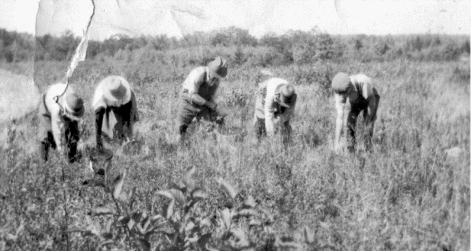
Raking blueberries ca 1920 at Sam Coopers
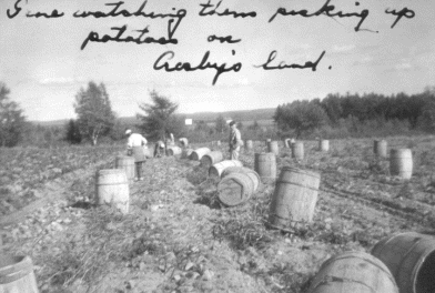
Dyer and Hilda Crosby raised potatoes in Alexander and Cooper ca
1955
And it has been the pleasure horse
people, a couple of folks raising beef critters and blueberries that
have filled the view through the windshield for the past 40 years,
that cleared land, a few more houses and woods. What will we see the
next 40? What will happen to those beautiful fields cleared for
blueberries?

Through the windshield we’ve seen how chemicals
have eliminated many weeds, how excavators have removed the rocks,
how machines have raked the crop. We’ve read how production per acre
has grown six times since WWII. We have heard of the provincial
governments of Quebec and the Maritimes still plowing money into
blueberry production. And we listen to our growers who lost money
this year; some left the crop in the fields.
What will we see through the windshield? Will
those fields grow up to deer pastures again, then into forests? Will
Farmers switch to growing fir boughs for Christmas decorations? What
type of things will grow on that land that has been sprayed? What
will grow in those fields we see through the windshields with
climate change?
FOREST: WHAT NEXT?
NOVEMBER 23, 2017
Last week we wrote about the fields, past,
present and future. We have limited open space in Alexander but huge
amounts of forests. Before the arrival of our first settlers our
forests had experienced change mostly by natural events. We were
under a glacier 15,000 years ago. As the climate warmed and the
glaciers melted, the barren land was colonized by plants. If we were
to travel northerly we would pass over land with a climate that
support the same plant life that was here at certain times after the
glacier.
As the forests developed
lightning strikes started fires that burned for weeks and miles,
stopped only by weather (snow or rain) or natural firebreaks (barren
places or water bodies).
Native Americans used the
forests passively as a place to get food (fish, meat and berries),
material for clothing (animal skins) and for heat. They occasionally
used fire to drive animals or encourage the growth of certain foods
like blueberries.
European immigrants brought
more people and a different culture of using the forest. Permanent
houses and wooden ships required harvesting bigger trees than the
native used. Their culture had iron tools, understood the use of
draft animals and could use waterpower to saw logs into usable
lumber.
The market for this big wood
was not only pines for the King’s Navy, but for ships to take the
pine across the ocean, to bring more immigrants here and for trade
between the colony and the mother country. Great Briton and the
Baltic countries had cut most of their forests and had excess people
without jobs. I expect, but don’t know for fact, that Alexander
pines were being sawn at East Machias and Dennysville before out
first settler arrived.
About 1880 for easy pine was
gone and loggers began harvesting spruce. First pine, then spruce
provided buildings down the East Coast, buildings for homes,
factories, schools, churches and, yes, sailing ships. Of course
railroad ties were in demand as had been fire wood from earliest
times.
The twentieth century brought paper made from wood
fiber. Man power and horsepower have been replaced by fossil fuel
power and huge machines, but it is still paper from wood fiber. We
have grown up with this and see it keeping the economy of Washington
County strong; but we know what has happened elsewhere in Maine.
Wildlands and Woodlands, Farmlands and Communities from
the Harvard Forest Foundation in 2017 reports that New England lost
480,000 acres of farmland and forests between 1990 and 2010. “over
the next 50 years…The threat of changing land use to forests is
greater than the threat of climate change to forests.”
If there is good news for forests in that report,
it is for northern and eastern Maine. Our farms may disappear, but
our forests are expected to thrive. We can’t eat trees, but our
forests can provide that connection to nature that our fellow New
Englanders to our south will cherish. What can we do to make
Washington County a nature magnet?
A
FUTURE VIEW THROUGH THE WINDSHIELD
–
November 30, 2017
The land of New England was forested when Europeans arrived. Over
time they learned what forest soil would grow food and selected
those places for fields. As the population grew marginal land was
cleared then abandoned. As news about the rich soils of Ohio spread,
many, especially farmers on marginal land, moved west; Go west young
man, go west!
What kind of forest will grow
on abandoned farmland? Last week’s article addressed abandoned
farmland in Alexander and Washington County.
In 1912 Herman Chapman wrote
Forestry: An Elementary Treatise. He reminds us that trees
reproduce by seeds (wind blown or animal scattered) or by sprouting
(stump or root). He writes of soil nutrients and moisture and how
dense grasses growing in abandoned fields hinder tree reproduction
by seed and allow more evaporation of moisture from the relatively
un-shaded soil. We also know that plowed soil results in a layer of
soil (the base of the plow zone) that roots can’t penetrate. This is
common especially in southern Maine.
So our conifers (pine,
spruce, fir) don’t do well in reforesting the abandoned plowed
fields. Those that get established grow slowly because of the dry
soil and shallow roots (especially in dry times like we experienced
in June, July, August and September of 2017). But the deciduous
trees like beech, birch and maple reproduce by sprouting from stumps
and poplar reproduces from root sprouting. Hardwood will even sprout
after fire kills the treetop.
On the Dudley Family Trust
Tree Farm on the Pokey Road, the blueberry field that was abandoned
in 1955 had lots of maple, birch and poplar harvested from it in
2013. The sheep pasture that was abandoned in 1935 had the above
hardwoods plus some fir harvested in 2013.
To see what our fields may look like in 2087,
drive down the road from the Four Corners to Pokey Lake. Seventy
years ago to the east of the road just one half mile was forested
(Lot 28) and on the west was all fields or pasture with three tiny
exceptions. And only seven occupied homes were seen on that two-mile
stretch of road.
The 2006 Comprehensive Plan of Alexander in Part
G speaks of scenic views of land, lakes and mountains that we see
often and of open spaces for recreation. East Machias recently set
aside a side hill in town for sledding, a lot with a view that could
have been sold as a house lot. Selectman “Bucket” Davis and his
board are thinking of the future in many ways. Our Comp Plan is
on-line!
ERIE CANAL #3
December 7, 2017

We wrote twice before about the affects of the
Erie Canal on Alexander. The canal was opened in 1825 and almost
immediately destroyed the market for Maine grown grain. The lower
priced grain from New York and Ohio shipped via the canal lead to
the abandonment of Alexander’s Breakneck Mountain settlement. The
second article told of how the canal provided an easy route for
eastern farmers to move west to more fertile land. Alexander’s
population peaked in 1850 and declined until the low in 1870. The
Erie Canal had its role in Alexander’s depopulation,
The construction of the Erie
Canal had some unintended and long lasting consequences. The canal
opened a waterway from the Atlantic Ocean via the Hudson and Mohawk
rivers to Lake Erie and eventually to the upper Great Lakes. Those
lakes hold about 20% of the world’s available fresh water and before
1825 the lakes were landlocked, except for Lake Ontario. by the
164-foot wall we call Niagara Falls.
By 1835 a sea lamprey was documented in Lake
Ontario, below the falls. It is believed these parasitic fish
arrived via a feeder canal from the Erie Canal. After the Welland
Canal was upgraded in the 1880s the lampreys moved into the upper
lakes decimating the larger fish such as whitefish and lake trout.
By 1970 an approved program of controlling the sea lampreys by
pesticides had been instituted.
But before this time the
lamprey had killed off the bigger fish and the food for the lake
trout and white fish went uneaten, which means their population
grew. It was river herring (alewives) that come up the canals that
ate this food. Alewives were too small for lampreys to hook on to,
so their population grew until ca 1990 they had exhausted their food
supply and they died by the millions.
Next came the idea of the St.
Lawrence Waterway. I remember the excitement in 1959 when this
waterway opened to middle America. Little did we realize that those
ocean-going ships would leave behind foreign bacteria and zebra
mussels. These mussels block sewage pipes and today we pay millions
of dollars to undo the damage they cause.
The information for this
article is from the book The Death and Life of the Great Lakes
by Dan Egan. How does this sad unpredicted environmental disaster
relate to our area?
THE CRAWFORD CONNECTION
December 14, 2017
In 1786 Rufus Putnam while in
Boston drew the plan for the Massachusetts Land Lottery, which was
fifty townships between the Schoodic (St. Croix) and the Penobscot
rivers. In 1784 he actually had surveyed on the ground seven
townships that became Perry, Pembroke & Dennysville. Charlotte,
Robbinston, Calais, Baring and Baileyville. Alexander’s (#16) odd
shape is because it fell between the actual survey of #7 (Baileyville)
and the square townships to our west.
Crawford (#20) is a square
township on paper and almost square by survey. All townships were
supposed to be 36 square miles in area. The square townships should
have been 6 miles on each side (6x6=36). Benjamin R Jones was hired
by John Black, agent for landowners William Bingham Heirs, to survey
Crawford into 144 settlers’ lots of ¼ square mile each. Each is ½
mile on each side or 160 rods.
By 1839 a couple dozen of
those Crawford lots had settlers. Lots sold in the lottery, public
lots (school & ministry) and settler lots could not be sold. So in
1840 Micah Talbot of East Machias purchased the rest of Crawford.
Talbot hired surveyor Richard V. Hayden of Robbinston to make a map
of Crawford showing land that Talbot owned. (We should note that
many had owned (or had made a small down payment on) the wildland of
Crawford including William Bingham, Neal Shaw and James S. Pike of
Calais). Hayden kept a journal that today is at the Calais Free
Library (built in memory of James S. Pike) with a copy available for
research. His record of his journey in the fall of 1840 is there to
read.
Crawford is in the East
Machias River watershed. The Popes and Talbots were the families in
East Machias who owned the mills and ships and needed logs to
manufacture into lumber to be sold and shipped. Township 21 is on
the St. Croix River watershed and the Duran and Copeland were two of
the many mill owners in Calais who also needed logs for lumber.
Charles Copeland had acquired
much of # 21 (Big Lake Township). It was, like Alexander, an odd
shaped block of land. Talbot claimed the north line of Crawford was
wrong, he claimed a strip of #21 ½ mile north to south and 6 miles
east to west or 3 square miles of land. Richard Hayden was hired
again in 1848, likely by Talbot, to survey. Both of Hayden’s maps
are registered and available at the Deeds’ Office in Machias.
How did this dispute affect
lot 26 in Alexander? Stay tuned; the research will continue.
BUYING ON TIME
December 21, 2017
The idea and information for this
article came from Jim Sullivan. He and his wife Dolly moved into
what we call the Francis Sullivan place at the corner of the Cooper
and Green Hill roads in Alexander. Francis was Jim’s father and a
son of the Thomas Sullivan whose records we will examine. Tom lived
in the yellow hipped-roof house down the road from Jim’s place.
On June 11, 1909 Tom borrowed
$421.00 from Ellery A. Drew of East Machias. The money was drawn on
Drew’s account at Eastern Trust & Banking of Machias at 6% interest.
Tom promised to pay $50.00 the first day of each November and May.
Tom made cash payments and paid off the loan on March 25, 1914 “by a
black horse”.
What caused the need for that
money? Tom and his family lived in a 3-bay cape, typical of area
nineteenth century homes. That burned sometime after 1900 and the
new house was built. Was the borrowed money for the new house?
Pictures of each home will be found in Issue 141 of the ACHS
Newsletter.
On March 27, 1915 Tom borrowed $210.94 and “sold”
to Sabra B. Drew “one mare colored chestnut known as Howard Allen
mare same I purchased from Sabra B. Drew; one bay horse white face
three white feet same I had from E. A. Drew. Tom’s signature was
witnessed by John A. McDonald. On the back of that document we find
a list of payments and “The within being fully paid the same is
hereby fully and freely discharged – Dec. 21, 1926 – Sabra Drew
McDonald”
On May 31, 1917 Tom acquired
from Sabra B. Drew “One State Prison Grocery Wagon, painted dark
frame, for $125.00”. Payments to be made each and every October and
March first until paid in full. Witnessing of signature by Verda P.
Hoyt.
All this took place without a
credit card or electronic record keeping, but these three documents
show that or ancestors could and did acquire needed items through
credit. We also observe where rural folks went for goods and
services, and the changes in those service centers.
TED WILLIAMS, AGAIN
December 28. 2017
Last fall neighbor Kate
Wright invited us down for a cup of tea and meet George and Dorothy
Hertel, her friends from Islamorada Island on the Florida Keys.
George was interested in history. He had moved to Amelia
Island after Gene and Estelle had moved to Leesburgh, but the couple
knew Jeff and Kate. Kate knew who could tell the history of the
Lodges, but had no idea of the connection that would result.
I had spent a good part of my
growing-up years next door and played there as well as on or in the
lake or in the woods and fields. Other kids were a long way up the
road so my friends were Catherine Beaton, Pond’s cook and Herbie
Fitzpatrick, Pond’s man who did everything but cook. Yes, they were
far older than I, but Catherine, from Cape Breton, baked cookies
that I sampled and Herbie let me hang around as he did his chores
like keeping the boats and motors in order and knowing where the
fish were biting.
This set of camps started in 1909 by Louis Adams
had been a family camp until the second owner Robert Pond died in
1947. At that time Eldon P, Embleton, a lumberman who had run
logging camps near Harvey Station, NB purchased them and turned the
place into a sporting camp for hunters and fishermen. In 1952 Gene
and Estelle Moriarty became the proprietors of Pocomoonshine Lodges.
They owned and ran the camps until 1988 when Jeff Wright bought the
place. Jeff died unexpectedly in July 2013 and his widow Kate uses
the place as a family camp, just what it was in 1917!
As a hurricane down in the
Caribbean moved toward their home in Florida, I told the three about
the Lodges. George looked on with interest and asked about the dog
kennels, the water tower and the “Delco system that produced
electricity. But it was when I mentioned that big tall baseball
player Ted Williams had fish on Pocomoonshine Lake from one of
Gene’s boats that George burst out with excitement. He knew Ted;
they had fished out of the same club at Amelia Island. And Ted had
fished here, and probably sat in this kitchen on this very chair.
Had Ted stayed at the Lodges? George told of Ted’s later years, how
he enjoyed a sip or two and how George would walk him home because
Ted lived across Route One from his favorite watering hole. And the
stories went on!
Connections - person to
person or place to place always excite me. How many readers or their
parent(s) met Ted Williams here at that time. I bet those who did
number at least in the dozens. Wish I had been the kid who Ted
invited to Fenway Park. He still lives in Milltown. Are there other
Ted Williams stories?
DAM WATER
January 3, 2018
Alexander’s landscape is
divided into three watersheds; the St. Croix watershed includes the
area abounding Wapsahagen Stream that enters the St. Croix River
just below Sprague Falls in Baileyville. The Denny’s River watershed
included the land around Pleasant Lake, the land around Meddybemps
Lake and both lakes. The East Machias watershed includes the rest of
the land that drains into Pocomoonshine, Barrows, Upper and Lower
Mud lakes. All six lakes listed have been changed by man.
Man’s dams have flooded all
these lakes. Most early dams such as the dam at the foot of Barrows
Lake were built to aid log driving and were temporary. The dam on
the Denny’s River at Meddybemps village was built in the 1780s
likely as a milldam and held back four to five feet of water. A berm
had to be built across Stoney Brook to stop the water from flowing
to the St. Croix River.
Hanscom Dam was about half
way between Rocky Brook and the bridge that carries the Airline over
the East Machias River. It probably served as a log driving dam as
well as a mill site. It would not have flooded back into Crawford
Lake. The dam and all the building burned in a forest fire between
1848 and 1855. Pokey Dam was then built at the foot of Crawford Lake
as a log-driving dam. The last drive to use Pokey Dam was in 1919.
In 1925 the dam was rebuilt to hold water for Bangor Hydro
Electric’s generating plant at East Machias. That held back the
water three feet higher than the present dam, so Crawford, the Muds
and Pokey were three feet deeper than now.
After the BHE dam was burned
in 1934, several men built a rolling dam at the site. Frank Magoon,
Perley and Conrad Woodruff and others wanted a dam from which to
trap eels as commercial fishermen and John M. Dudley wanted the dam
to maintain waterfowl nesting area. They agreed on the water level
and built a dam. It was replaced ca 1955 the Maine Fish & Game
Department rebuilt the dam. Crawford – Pocomoonshine Water Shed
Association built the present dam ca 1985.
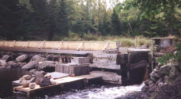
Pokey Dam 1999 with flash boards, ready for eel trapping.
Three dams were built to
harness waterpower for saw or gristmills, Stephenson – Dwelley mills
at outlet of Pleasant Lake, Gilman – Dwelley Mills on the Denny’s
River, and the Dwelley mill at the Dwelley Canal in Meddybemps. This
short canal was dug to provide another mill site powered by water
from Meddybemps Lake.
Denny’s River Electric Corp
or Harry Smith generated electricity at the dam in Meddybemps ca
1945 for several years.
Today most area dams are kept
by associations to maintain ecological stability and beauty by
maintaining the dams and water levels. Are the lakes pleasant to
look at? What will folks think in 200 years?
SPECIAL WATER ENVIRONMENTS
January 10, 2018
The name heath describes a
special kind of wetland or peat bog. It is unique in that under a
heath is a glacial deposit of sand or gravel. Over that is a
relatively thin layer of peat that is made of partially decayed
plants, but just certain plants. To be a heath, this whole thing is
fairly level on top.
Dennis and Lloyd Gillespie
told me of the onetime existence of a set of buildings at the edge
of the heath and solid ground, by the Green Hill Road. This story,
passed down in the family, may have referred to a logging camp, but
how would the logs be gotten out to open water. It could have been
an operation to mine iron from the bog. Bog iron is an impure form
of iron that bacteria or algae extract from the mineral rich water.
As the material accumulates, it sinks to the bottom and the miners
scrape it up. Blacksmiths in inland rural Maine refined and used bog
iron for tools, etc.
The dam at Meddybemps on the
Dennys River has put more water over the heath, but in 230 years has
not really affected what 10,000 years had built.
Wheelabrator-Frye considered
mining peat from the heath in 1980. It was designated as a National
Natural Site in 1973. From the Cooper Road it is part of a wonderful
unique view. If you would like to easily walk through a bog, the
Orono Bog has a boardwalk.
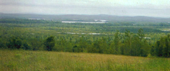
Meddybemps Heath image from WCCOG
Or you can ride on your
favorite watercraft down the Main River from Pocomoonshine to
Crawford. This lets you see another wonderful view, but one that has
been created by man.
Two hundred years ago the
river would have been narrow, with cedars and alders hugging the
shores. Beavers might have created ponds (Upper & Lower Mud) with
dams to haul over. River drivers would have cleared the dams and
other obstacles. Farmer would have cut and/or burned the wetland to
encourage meadow hay (food for oxen), the BHE high dam would have
drown the roots of remaining trees leaving more land for meadows.
And from the dams since 1936 the water level has flooded the meadows
resulting in huge marshes.
Are these man made changes to
out environment good or bad? Consider, the Pokey Dam since 1925 has
created marshes around and between the lakes. The shallow water in
the marshes warmed by the sun heats the lakes. The trout and white
perch of 200 years ago have become large mouth bass and pickerel,
both introduced by man. Good or bad?
WHERE HAVE THEY GONE?
January 17, 2018
About twenty years ago ACHS was trying to collect
information on immigrants and emigrants, those who came to Alexander
from where and to where did they go when they left Alexander. Marie
Harrington from Benton sent her Cooper information that was not
shared with readers at that time. Here is the story of Marie’s
Cooper ancestors and how they moved around.
Nathan Yeaton came from New
Hampshire to Eastport and then to the East Ridge Road in Cooper. His
wife Hannah Sadler came from Cape Ann in Massachusetts. She is
buried at the East Ridge Cemetery.
Nathan’s neighbor William
Sadler also was from Cape Ann, MA and arrived in Cooper via
Eastport. His wife Hannah Millett followed the same path and ended
up at the East Ride Cemetery.
John Hayward came from
Windsor Township, New Brunswick to Cooper (North Union Road), next
moved to Wesley and then on to St. Cloud, Minnesota. His wife
Margaret Sheck came from Sussex Corner, NB. Their son Henry married
Azuba Higgins and both are buried at the Evergreen Cemetery. Some of
their descendants are still found here in Washington County.
Nathan Higgins family had
arrived on the Mayflower and came to Cooper after a stop at Eden
(now Bar Harbor). Nathan married Anna Leland whose parents came from
Providence RI. A stone for J. R.
Higgins, of
Co. F. 6th Maine Infantry is at East Ridge Cemetery. The family
lived north of Cooper Highway on Middle Ridge and an unusual small
walled family burial plot in the woods guards all who rests there.
My ancestor Daniel Lane came
to North Union Road in Cooper from Calais. His wife Temperance
Pettigrew’s family had moved from Machiasport to the Ledge NB
(across the St. Croix from part of Calais. Actually the ledge was in
the river and caused problems for ships). Dan and Temperance are at
the East Ridge Cemetery. Several of their grandchildren migrated to
Brooklyn Center, Minnesota. Some of their descendants are still
around Washington County.
When neighbors today speak
about new faces in town or comment about how quickly some disappear,
I comment, “Nothing has changed but the names and faces.”
ALL ABOARD!
January 24, 2018
My friend John Andrew was at the
Maine Woodland Owners meeting recently and gave me information on
the Washington County Railroad and its connections. That word
“connections” caught my eye. What was the connection of this link to
the outside world and Alexander?

Image from THE SUNRISE ROUTE by Mike Zimmermann
The WCRR, sometimes called
the Sunrise Route ran from Washington Junction near Ellsworth
easterly to Eastport and Calais, the first through trains running in
1900. The original half of the Wabanaki Heritage Center on Union
Street in Calais was the station and headquarters for the company.
Available transport to the
South and West by land was limited to the Airline Stage (1857 to
1887) or the Shoreline Stage. Regularly scheduled steamboat service
from Calais to Bangor/Boston via Eastport existed (see the “Rose
Standish” on the wall of the Thrift Shop in Calais) and was the
business competition for the railroad,
The route of this rail line was through the
populated part of our county. The stage connections described below
are mostly from the station to rural interior communities.
The Sunrise Route provided
stage connections from their stations for people and freight to many
towns beyond the shining rails. From the West, the first station was
in Unionville, but the population was 6 mile away in Steuben, the
fare was 50 cents. From Cherryfield Station (still standing) the
stage went to Beddington for $1.00 with stops in Deblois and South
Beddington.
Skipping to the East to
Machias the stage ran to Wesley (21 miles for $1.00) with stops at
Marshfield and Northfield. For 50 cents one could ride the stage 14
miles from East Machias to Plantation 14, now Cathance Township. At
Ayers Junction in Charlotte a spur line went east. Conductor Ross
Haycock would announce, “Depart for rail to Eastport and Perry,
don’t forget your packages or your babies!”
At Eastport ferry connections
were available to Lubec, Campobello, Deer Island, Back Bay and St.
Andrews NB. And for those of you who want to come home to Alexander
from the Calais station, the 14-mile ride will cost 85 cents.
The Sunrise Route pamphlet
makes no mention of the St. Croix and Penobscot RR from Calais to
Princeton or European & North American RR from Vanceboro to Danforth
and connecting Halifax, NS to all the US markets.
Thanks, John & Mike Zimmerman
author of The Sunrise Route
KNOWN FAMILY CEMETERIES IN ALEXANDER
February 1, 2018
Did you know that during the first 50 years of
settlement no one was buried in a public cemetery, all burials were
on the homestead or possible at a neighbor’s or at the cemetery on
the parents’ place? The earliest document of a public cemetery was a
deed granting the town from Solomon Strout for a burial lot on the
west half of lot 66, north of the Airline. That was dated January
10, 1863. A half dozen bodies were interred there, but the place was
abandoned, likely because the field was full of rocks and the
digging was hard.
That abandonment also may
have been because on February 18, 1876 Albion K. P. Berry and Albion
H. Perkins deeded “Sand Hill” to the town for use as a cemetery
where the digging is easier. This today is the site of out Alexander
Cemetery. The bodies at the Strout site was disinterred and reburied
on Sand Hill; the now unused graves were never filled or leveled
off.
Relatively primitive
understanding of the causes and spread of diseases lead to numerous
childhood deaths into the early part of the twentieth century. Lack
of training of midwives also resulted in mothers dying at
childbirth, too often at the woman’s first and only time giving
birth and also, too often, the baby died at the same time.
Evie (Keen) Cousins was a
midwife here during the first third of the twentieth century. She
helped with the successful birth of many born in this neighborhood.
Her husband Charles “took care of the dead; he placed pennies on
their eyes’ to close them, and he prepared the bodies for burial.
Recent activity of a group visiting family
gravesites in Cooper prompted me to look again at telling what I
know of family gravesites in Alexander; and what I know came to me
through the stories of my friends and neighbors, most of them
resting now in peace. Like most towns, the family cemeteries are on
private property and require landowner’s permission before the
visit. A list of private cemeteries is in the Vital Records of
Alexander starting on page 190.
Three known sites are recent.
When Warren Barnaby drowned in November 1981, his wife
Valerie chose to have him buried on their homestead. The site is
near 1839 Airline Road. Roland and Grazina Paegle created a
memorial site on Baltic Island on Barrows Lake for placing ashes of
their loved ones. And when Gwyneth Pollock died on her way to
WA in September 2002, her parents Kit and Carol chose to create a
special place for her ashes near their home on Weymouth Place at 69
Tommy Long Road.
TWO FAMILY CEMETERIES IN ALEXANDER
February 7, 2018

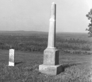
FLOOD FAMILY CEMETERY
This well cared for family
burial place is located on lot 112 that was the long time farm of
the Flood family. The site, now owned by Bruce Baker, was restored
by Evelyn (Flood) Pottle after the stones had been moved; Rollin
Small of Pembroke did the actual work. The cemetery can be seen from
the Cooper Road near the Green Hill Road junction. Bruce, who
maintains the site now, should be asked for permission to walk to
the stones.
Written on the stones:
Peter Flood died 1845
His wife Lucy S. died
1862
Willis O. Flood died
1857
Levi Flood died 1891
(Civil War soldier)
His wife Mary A.
(Webber – died 1938)
Wesley Flood died
March 1, 1901
Who else is buried here? Some
later Floods are buried at the Alexander Cemetery.
JOHN G. TAYLOR –
CONNICK CEMETERY
This site in a field on lot
106 has one fieldstone and several grave sized depressions. Robert
Flood, grandson on long time occupant Raymond Flood, is the owner.
Records show that Alexander’s
first Town Clerk John G. Taylor lived on this lot. He died
October 14, 1841 and I suspect he is buried here. I honor his
eighteen years of service to the town and his records that allow
historians to know the past.
After Taylor died, the next
known occupant of this farm was Paul Morse and his wife
Mary Anna Morse. Paul died October 31, 1855 and Mary Anna died
on July 7, 1858. I believe that they are also buried in this site.
Mary Anna was first married to a Trask and her son was John William
Henry Trask (born 1816). He remained at this home site until after
the 1860 census. He was just 44 then and disappeared from our
records.
Records indicate that Luke
Stephenson (born 1826) lived here in 1900, I believe he is
buried here. Luke married late in life Mrs. Martha Conick.
Even though her name is on a stone at the Evergreen Cemetery
in Cooper, I know she was buried her because Evelyn (Flood) Pottle
lived as a child in the Lincoln Flood home across the road, Martha
Connick lived with the Flood family before her death and Evelyn
witnessed the burial from her living room window.
Thursa Cousins Sawyer told
Robert Flood that she and Evelyn decorated the grave of Mrs. Connick
at this site. Strange that Mrs. Stephenson was called Mrs. Connick
by those who knew her. Martha deeded lot 106 to Lizzie Perkins Flood
in 1908, who in turn deeded it to son Raymond Flood in 1931.
Family tradition has it that
a Mrs. Buck is buried here. Who was she? Was she related to
John Taylor or his housekeeper? Ralph Flood told Robert Flood that
Ralph’s mother was Mary Buck of Princeton. Her parents were George
Buck and Janet Weatherbee of Little Ridge NB. George was born
Berry, was raised by Silas and Relief Buck and took their
name.
TWO MORE FAMILY CEMETERIES IN ALEXANDER
February 14, 2018
CROCKETT – DAVIS FAMILY CEMETERY
In the past I have referred
to this site as the Sears Corner Cemetery after the most recent
resident of the place. However it appears that this is a family
cemetery. One stone has been found here under a maple tree at the
edge of an overgrown field. The stone reads:
Lucy E. died 1863, wife of
William V. Davis.
William Valentine Davis was a
grandson of William D. Crockett, a veteran of the War of 1812. The
1860 census of Alexander give the residents of that house at
Crockett’s Corner as William V. Davis (age 30), Lucy E. (27),
William N. (4), Frances H. (8/12), Matilda E. Bird (20 & a sister of
Lucy), and William D. Crockett (80). I believe that William D.
Crockett (1782 – 1862 and his wife Rebecca (Barber) (1784 – 1855)
are both buried here. Where else? William and Rebecca had four
unmarried daughters Are they buried here?
One other person may be
buried here, being John Sear’s first wife Mary Olivia (Berry). John,
a Canadian from Sackville NB and a Civil War veteran, moved from
Baring to the William Crockett place between 1872 and 1879 when Mary
died on July 8. John remarried in 1885 and disappeared from
Alexander records.
BREAKNECK
Here is an unusual but
documented story of a community cemetery that has not been located.
And here is a quote from the Calais Advertiser.
“On
Tuesday last an inquest was held by Coroner D.K. Chase upon view of
the bodies of John S. Phillips, Joel Gooch and
Reuben T. Fenlason of Alexander, which were taken lifeless from
the bottom of a well near the dwelling of Mr. Phillips. We are
indebted to the Coroner for the following.
“On Monday the 9th (1852) inst. Mr. Phillips
had the water bailed out of his well which was about thirty feet
deep, and had not been used for a year or more, and he went down
into the well and cleaned it, and put fire to a handful of straw and
threw it down to burn up, as he said, the unpleasant smell.”
The men listed above all died in the well and
eventually were buried near that well on Breakneck. Had this site
been used to bury others from this isolated community? Years later I
was told of a marble gravestone leaning against a tree near the
site. The second “O” in Gooch had a bullet hole through it. History
has its share of mysteries.
THREE FAMILY CEMETERIES IN ALEXANDER
February 21, 2018
BOHANNON FAMILY CEMETERY
Annaniah Bohannon was an early settler in
Alexander and built a house nearly half a mile north of the present
Airline Road on lot 65. The first recorded death of a white woman
was of Mrs. Mary Young who died at age 27 on April 18, 1814; she was
a sister of Annaniah’s wife Amelia (Campbell). Mary was likely the
first buried in this cemetery. Years ago three broken stones were on
the ground at this site. They read:
“ (Bo)hanon died 1857, age 64” ie Amelia (April
11, 1792 – February 7, 1857)
“ Elijah Brown died 1849” he was husband of
daughter Amelia Bohannon
“
Orrae died 1861”
“
Walter C. died 1863”
These two were grandchildren
of Annaniah & Amelia, children of Jones & Elizabeth
The stones have disappeared
into the ground as a result of blueberry growing.
Amelia and Elijah Brown had
two more children who may have been buried at this site: George
Washington Brown (1837 - 1845) and Eliza Brown (1839 - 1845). These
two died only one day apart, of what?
COLE CHILDREN’S GRAVES
William Cole came to
Alexander early in 1830 and settled on lot 64. . William and his
wife Eliza (Chase) had eleven children before leaving town. Three
died young and are buried in graves marked by only depressions in a
blueberry field. Alexander Vitals compiled by Sharon Howland tell us
that Mary Temperance Augustus Cole (August 19, 1839 – August 23,
1845), James K. Polk Cole (September 5, 1844 – August 26, 1845) and
George M. Dallas Cole ((September 5, 1844 – December 26, 1846). What
was going on in 1845 to the Brown and Cole children?
JEREMIAH FROST FAMILY CEMETERY
An oral history from Pliney Frost tells of Family
Cemetery on the east part of lot 66. We did not find the site in the
woods that Pliney remembered as a hay field. Tom Smith who lad lived
on the farm in his youth took me directly to the fieldstones. Pliney
told of Jeremiah Frost Jr. (born 1779), his wife Sally Thompson
(1787) and two of their children Joseph (1824 – 1824) and Susan
Lavina (1826 - 1827) who were buried here. Jeremiah Frost Sr. died
on March 3, 1820 in Alexander. Was he the first buried at this site?
Thanks, Tom, for showing me the site.
LAST LIST OF KNOWN FAMILY CEMETERIES
February 28, 2018
At the north end of the Robb
Hill Road was the home of that family from Northern Ireland. Harris
Brownlee told of two graves in the yard, Harding men who had
died logging there after the Robbs had moved off the hill. The Robbs
were Protestants when in Ireland, but became Roman Catholics here;
thus they likely are buried at the Catholic Cemetery in Calais or
later at Woodland. Graves of Catholic residents of Alexander are
common at the Calais Cemetery. Families buried at Calais include
Blaney, Cotter, Foley, Hackett, Leahan, Robb and Tracy.
BROWN CEMETERY
At the top of Taylor Hill,
west of Robb Hill were graves, the only one we are sure was of
Samuel Brown (1759 – 1850). Sam was likely Alexander’s first
settler. One of his daughters married a Taylor, thus the name of
that steep hill on the South Princeton Road. How many were buried
here? The stones were moved out of the field by Beaupre to grow
potatoes to fed his family and pasture his horse.
MOORE FAMILY BURIAL LOT
John Moore from
Ireland came to Alexander before 1820 and settled on a twenty-acre
farm on lot 78. He married Nancy Moholland and raised a family on
that small acreage.
He died on June 4, 1852.
Nancy followed him down that path of no return on December 29, 1856.
She was buried beside her husband, plus likely a son named John
(1837- 1837) in an unlocated cemetery on their farm. When his son
sold the land he excepted a 30’ x 30’ burial lot. Where is the Moore
Family Cemetery?
PERKINS
Maria, first wife of John Perkins (1793 - 1872)
died in 1836 and is buried in the yard of Irene (Carlow) McKain on
the Cooper Road. Later John married Lucinda Bohanon. Their place of
burial is unknown. The stones at Irene’s have been moved; old Foster
Carlow remembers four stones. One was for Elisha Perkins (1784 –
1847).
Other Reported Graves
On lot 105, near the road
(Lincoln Flood Place).
On lot 37, in back of where
Mel Hunnewell’s house stood
On lot 101 (Gooch Lot) maybe
the peddler
East of potato house on what
was Sprague lot
Many folks helped on this
project. Pliney Frost probably helped most.
|