HISTORY OF SOME
EARLY COUNTY
ROADS
RELATING TO
ALEXANDER AND OUR NEIGHBORING TOWNS
The purpose of this research and
article is to give the writer and reader a picture of the early
development of roads in our area. Since I depend on county
records, we will read about county roads that ran between towns,
generally not roads within a single town. But we must be aware that
town roads that connected to the neighboring town’s roads often
became county roads. Wording within each petition gives a clue as to
whether the road was in existence before the date of the petition or
was for a new road through the wilderness. Enough wording here is
taken from the original documents to give readers a taste of the
language of the past and clues as to why the petitions were
submitted. Much of the wording has been heavily edited. [Factual
explanations are in brackets] Editor’s explanations, or best
guesses, are in Italics. Corrections are desired by John Dudley,
216 Pokey RD, Alexander ME 04694
Primary source: Washington
County Record Books – starting on June 22, 1790. The six volumes
are available on USB in PDF form. Given as WCRB within article, the
books contain a record of the work of the Court of General Sessions
of the Peace of Washington County. This court became the County
Commissioners by September 1831. From 1790 through 1800 the
following men were listed, in order of appearance, as members of the
Court: Stephen Jones, James Avery, Joseph Pierpont, John Crane,
Alexander Campbell, Lemuel Trescott, Daniel Merritt, George Stillman,
Phenias Bruce, John Brewer, Caleb Coolidge, Benjamin Ruggles,
Theodore Lincoln and John Allan. These men have been responsible for
the county government, then as now. Were women ever part of the
Commission?
Their duties included having a
courthouse, being justices in a court for more serious crimes and
maintaining a goal [jail]; they also provided for roads, toll and
free bridges, approved ferry operators, and taxed for all these
services. No mention of elections is made prior to 1809. This is
strange considering that a rallying cry of the recent revolt against
the British was “No taxation without representation”. The first
mention of an election was in 1809 [Vol. 1 pg. 181] in which George
Stillman Smith received 244 out of 358 votes, thus was elected
County Treasurer. In 1827 Smith was elected both County Treasurer
and Register of Deeds. At that time only free white male
landowners could vote. Of interest, we might note that money
accounts used dollars and cents starting in 1795.
Other sources:
Colby’s 1881 Atlas of Washington
County
Deeds at Machias and Ellsworth
Travel on roads with GPS
Wallings 1861 wall map of
Washington County
The following map shows Washington
County somewhat as it was from 1789 to 1839, when Aroostook County
was created. Actually before that Washington County ran north nearly
to the St. Lawrence River. In my limited research of these County
Records I have found no reference to the Acadians living along the
St John River valley.
We do find several petitions from
Joseph Houlton to have his township connected by road to the
Shiretown [Machias]. His petition speaks of a most noble need, and
of a road to present day Haynesville that settlers are building.
This map will allow readers to see
the towns and townships that these roads passed through. Readers
will understand, even with Danforth being the northern most town in
our county, the major problem caused by the large geographical area
with such a small population. Our county population is about the
same as Portland’s. Services that people ask for, such as roads,
cost money
Other maps follow. Each petition
or other entry is keyed to a map or maps to help readers find its
location. An up-to-date highway map would be of further help.
MAP A – WASHINGTON COUNTY

Map from Maine State Highway Commission 1959
ROUTES 1 & 187 – STUEBEN TO
INDIAN RIVER – WCRB Vol. 1, pg. 7 – MAP A
1790 Report to Court of General
Sessions of the Peace
This is the first
mention of a road in these Record Books.
There were roads before Washington County was set off from Lincoln
County in 1789. Part of the road described here was likely used by
Loyalists of Castine to escape to British North America [Canada]
after the Revolutionary War [1783]. Wealthy Loyalists traveled by
ship, the poor walked.
The report
describes a new road from the western boundary of the County in Plt.
4 [T 4 EUR LS or Stueben: EUR = East of Union River and LS is for
Lawrence survey of 1763].
It started at Parrot’s Mill on what today is Whitten Parrott Stream.
[Spelling of many old names have standardized] It was to pass over
several bridges up to 300 feet long and parallel and actually follow
the old road in many places. It ran through Stueben and Addison to
the east boundary of that town at the village of Indian River.
What other towns did it pass through?
People lived along
the old road and some names mentioned from west to east are Whitten
Parrott, Baker, Downs, Townsley, Tracy, Oaks, Guptail, Campbell,
Fickett and Damon. After crossing Pleasant River, the road swung
southeasterly to Indian River.
PLANTATION #22 TO PLANTATION
#18 ROAD – WCRB – Vol. 1, pg. 97 – MAP A
1800 Jury Report
This report describes the use of roads in that
time, and it appears that this road was in such disrepair that some
person took the government to court. In 1800 the entire road
described was within Machias. Its course from Jonesboro might have
followed Route 1A to Whitneyville village, then the Marshfield Road
to Route 192, Cross Road, to Scotts Hill Road to East Machias and
Route 191 to Berry Township line. Remember that Machias in 1880
included Whitneyville, Marshfield and East Machias.
Jury presents the verdict that the
County Road from Plantation #22 [Jones, Chandler River and now
Jonesboro] to Plantation #18 [Berry Township] is a common highway
for all the good citizens on horseback and on foot to go, return,
pass, ride and drive their cattle. The whole highway with bridges
contains the length of thirteen miles and in breadth three rods.
Does “ride” refer to wheeled traffic? No reference is made to oxen
or ox carts. When did they show up in Washington County?
COUNTY ROADS IN ALEXANDER AND OUR
AREA
To understand why the following
happened when it did we must know when people came here. We believe
Sam Brown and his family was living on lot 9 Alexander before 1810,
but the census taker thought he was in #17 [Princeton] and he also
believed that, according to family tradition. We do know that the
census gives Alexander’s population in 1820 as 114. It grew to 336
in 1830, then to 513 in 1840, and reached its greatest number ever
at 544 in 1850. Our neighboring towns had population growth less
then Alexander’s but reflecting the same pattern. Coastal
communities from Calais to Steuben were settled earlier thus had an
earlier need for roads.
CALAIS TO MACHIAS –
Schoodic to Machias – WCRB - Vol. 1, pg., 163 – MAPS A & B
1806 Petition by Committee of Wm.
Emerson, Moses Elsmore, Jabez Huntley Jr, Enoch Waterhouse, John
Coffin Talbot charged with finding shorter way from Schoodic
[Calais] to Machias
Enoch Waterhouse laid out,
spotted trees and ascertained the places and
course of a road from Machias to #5 Schoodic [now Calais].
The planned road generally went Route 1 from Calais north into
Baileyville, westerly north of the Airline to near Alexander’s
Cooper Road, hence southerly connecting to Route 191 at Grange Hall
corner in Cooper. Here are some points mentioned by Waterhouse
starting at Downes & Pikes somewhere near Eastern Maine Electric
Co-op at North Street and Union Streets.
Round Magurrewock Mountain
Spelling found on 1861 map
Cross Magurrewock Meadow and
Brook
Cross Barn Meadow and Brook
West line #5 [Calais – Baring
line]
Vance Mill [Baring] 5 miles. In
1818 William Vance got the deed for 700 acres in #6 [Baring] with
buildings plus 2 & 3 in #7 [Baileyville]. Deed 10.353 from Alexander
Baring etc.
D. Stone Land Stoney Brook?
Bailey Hill 9 miles and depart
Schoodic River He turns west at the very top of Bailey Hill.
From Calais to this point he follows the present day road, Route One
North, and the measurements are close considering the old road has
been straightened. [In 1806 Nathaniel Bailey’s sons and several
others were living in Baileyville and likely used a trail or road
described here.]
We note that no mention is made
of a road or trail to the west and none are found on old maps; the
present Airline apparently was not even a spotted trail in 1806, nor
were the Charlotte road or Route 191. For the next 5 miles
Waterhouse mentions land, high, low, spruce, good, hemlock,
hardwood, rocky and mixed growth. [No road and no settlers here.] He
does mention a brook 3 miles from Bailey Hill [Wapsaconhegan Brook].
About 5 miles from Bailey Hill he turns southwesterly somewhere
near the north end of the McArthur Road and goes through the
woods somewhat following present day McArthur and Cooper roads to
a cedar swamp, Henderson Swamp in Alexander, to the…
Outlet of Pleasant Lake [note the
historic date of this name]
North line of #15 [Cooper]
Yoho Brook Dead Stream?
Yoho Mountain Pineo Mountain?
Enoch Waterhouse Farm at 12 miles
from Bailey Hill [First mention of a settler since the Schoodic
River. This farm was on Grange Hall Corner in Cooper]
Huntley Brook [Mill Stream]
Emerson Brook – 2 miles from
Waterhouse Farm. [Doten Brook at foot of West Ridge – Cooper;
this was likely named for William Emerson, petitioner, who
eventually lived in Baring next to the Dennys River in what today is
Meddybemps]
Jabez Huntley’s House
[on Ash Ridge in TWP 14 or now Cathance Township].
Jabez of TWP #14 bought this 100 acres from John Munson of Machias
in 1805
Road to #13 [Marion – Route 84]
and to #18 [Berry Township – Route 191] - 20 miles 105 rods from
Bailey Hill [Lund’s Corner] In 1806 this was the home of Ebenezer
and Mary Downs who had come from Stueben. They gave the farm to
Alvin and Alden Bridgham so that the Downes minor children would
have guardians. This 200 acre farm included references to White Ash
Meadow Ridge, Partridge Lake, Tavern Brook and Clifford Stream.
22 miles bridge [Southern
Inlet]
22 miles198 rods Bailey Hill to
Machias north line [now East Machias north line, which is south line
of TWP 18, now Berry Township]. We must realize it was a long
slow process from wilderness to highway. See petitions for 1820, 26,
29, 33 and 36.
MAP B – ALEXANDER ROADS
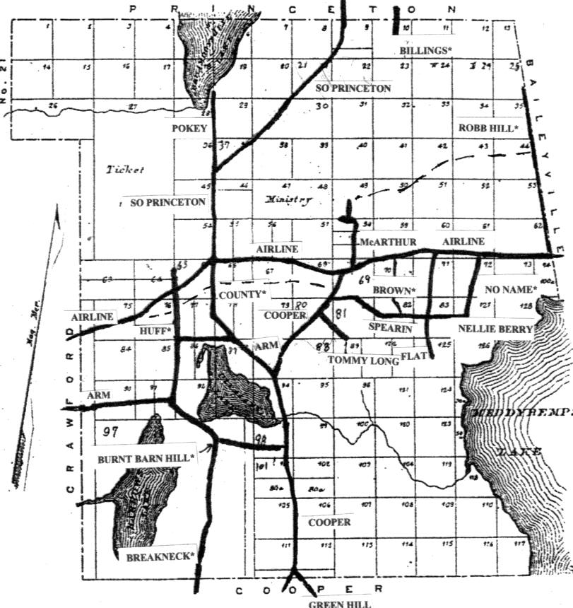
Map based on Benj. R. Jones 1808
plan of Alexander found in George Colby’s 1881 Atlas of Washington
County – roads ca 1850 drawn by John Dudley
1806 Calais to Machias – proposed
road from top Bailey Hill to Alexander through lots 44 on Robb Hill
westerly to McArthur Road – follow dashed line
1820 Petition Lunds Corner to
Alexander
1821 Petition for road from
Alexander to Calais [present Airline?]
1835 Petition for South Princeton
Road
1839 Petition for New Airline Road
in Alexander – dashed line approximates old road through lots 76,
77, 65, 66, 67, and 68
1843 Petition for Arm and
Breakneck roads.
ROAD FROM LUND’S CORNER TO
ALEXANDER – WCRB - Vol. 1, pg.296 – MAPS A & B
1820 Petition
Make alterations to road
leading from county road from Machias to Dennysville. The
county road in 2014 would be Route191 from East Machias to Lund’s
Corner and Route 84 from Lund’s Corner to Dennysville. The road
to be altered goes through #14 [Cathance Township] and #15 [Cooper]
so it can become a public highway and county road. A survey of the
route was presented to the Committee meeting at the home of Ebenezer
Downes in #14. Route of road follows: [This is essentially part of
the Calais to Machias road surveyed in 1806, see above]
Starting at the north line of #15,
[The line in 1820 was near 865 Cooper Road.] near the house of Major
Paul Spooner... and going in a southerly direction for 12
miles & 141 rods to near the house of Ebenezer Downes in #14. The
road was 4 rods wide. [A rod being just over 16 feet]. Today a
paved road for over ½ mile follows the survey. Where the road now
swings left, the surveyed road, and actual road did continue pretty
straight up over Pineo Mountain where it intersected with the
Breakneck Road, and straight onward to present day Grange Hall
Corner. From there the survey closely follows southerly Route 191 to
Lund’s Corner. Most of the land was owned by the Proprietors or
persons unknown. Awarded for damage were Otis Pineo ($15.40),
Jonathan Carey ($17.00) and Samuel Rich ($9.00), all of #15
[Cooper].
ASTPORT TO ALEXANDER ROAD –
WCRB - Vol. 1, pg. 317 – MAPS A & B
1821 Petition signed by Simon
Porter and 5 others
Road now traveled
from Eastport Bridge in Perry to Lower Bridge on Pennymaquan Stream
in Dennysville [this place in Dennysville is today in Pembroke]
might be improved and straightened through Dennysville [now part of
Pembroke], #3 [Charlotte], #6 [Baring], #15 [Cooper] and part of #16
[Alexander] to intersect with the road from Machias to Calais. No
route description is given in petition. [In 1821 Meddybemps did not
exist, it was created later out of parts of Baring, Charlotte and
Cooper].
The route via 2014 roads north from Pembroke
Village would follow the Mount Tom Road and part of Route 214 north
to the bottom of Conant Hill where it intersects with Route 191. It
follows 191 through the village of Meddybemps [Gilman Mills] to the
Green Hill Road. Hence through this now partly abandoned road to 856
Cooper Road in Alexander, by Nelson Flood’s Barn. See 1808 survey of
Schoodic [Calais] to Machias Road
ROAD FROM ALEXANDER TO CALAIS
– WCRB – Vol. 1, pg. 344 – MAPS A & B
1821 Petition by Stephen Babcock
for a road from Plantation 16 to Calais. Follow-up by Commission in
1824 shows that a committee was formed to survey and return a
warrant on said road; Committee declined to serve and all further
proceedings on Babcock’s petition henceforth stayed. [The 1821
petition was not found and no survey was found.]
Who was on the committee?Route was likely along
present day Airline.
OLD CRAWFORD RD in Cooper –
LOVE LAKE RD in Crawford – WCRB - Vol. 1, pg. 357
1823 Petition signed by Simon
Foster of Cooper and five others – MAPS A& C
We the undersigned Inhabitants of
Washington County beg leave to represent to said Court that a new
road or public highway from the County road leading from Machias
to Calais, near the dwelling house of John Cooper, in Cooper,
through a part of said Cooper, through a part of Plantation number
nineteen, through a part of Plantation Number Twenty [Crawford] to
intersect the road leading from Penobscot to Schoodic commonly
called by the name of Blacks Road [Airline Road] near the dwelling
house of Aaron & Elkanah Hanscom, residents, but not land owners in
#20. The actual survey was undertaken by in 1824 John L. Harris,
John Chaloner and Benjamin Getchell and measured 4 miles and 303
rods. We note here the prior existence of
what we call Route 191 and Route 9, the Airline.
MAP C – OLD CRAWFORD ROAD
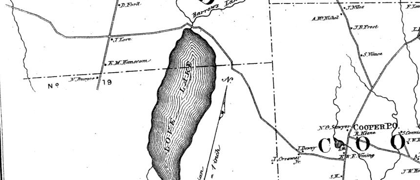
Map from George Colby’s 1881 Atlas
of Washington County
COOPER TO CALAIS ROAD –
WCRB – Vol. 1, pg. 360 – MAPS A, B, C & D
1823 Petition by William Vance
and 32 others
We the Inhabitants of Cooper,
Plantations Number Six [Baring], Seven [Baileyville], Sixteen
[Alexander], and Twenty [Crawford] request a public highway*
from Cooper to the public highway [now Route One] along the river
St. Croix or Schoodic above Calais – having no direct road to Calais
where Inhabitants must go as a market and outlet for the surplus
produce of their soils and other articles and for articles of
importation. The petition was approved and Benjamin R. Jones,
Ebenezer A Wilder and Elias Foster made up the committee to survey
the way. Proprietors were allowed time to remove timber and trees
from the public way. *The present day Airline was then a private
road.
A description of the survey starts
at the termination of the County Road near Paul Spooner’s
bars near the [Alexander – Cooper town line].
Here are some points readers might recognize along
the Cooper Road in Alexander, east on the Airline and down Route One
to Milltown.
A rod west of Peter Flood’s house
[lot 112] – by John G. Taylors bars, near his log house [lot 106] –
across the outlet of lake above Stephenson’s mill – by entrance to
Bailey Road [Arm Road] to Penobscot Road [Airline Road] – across
Wapsconnegan [Stream] – by Great Cold Spring [Robb Watering Hole
west of Bear Cove Road] – south of Mahar’s house – Keeping near old
road south to William Vance’s barn [Baring] – cross Barn Meadow –
Magurrewock meadows – by O’Brien’s Ledge – to J. C. Todd’s home in
Milltown, near the mills. These roads
existed prior to the survey, the purpose was to make the way a
public highway with county money used to improve the road and
maintain it. Some Cooper inhabitants follow this road even in the
twenty-first century. We might note that the roads from Alexander to
Machias and Eastport were opened before the road to Calais.
HOULTON ROAD – WCRB – Vol.
1, pg. 364 – MAP A
1823 Petition signed by Joseph
Houlton and 24 others
We the Inhabitants of Houlton
Plantation believing settlement of land is a principal and important
object of Government, we need to open a road to tide water as
opposed to communicating through the British Province of New
Brunswick, or via boats on the St. Croix River or via boats on the
St John River. The inhabitants of Houlton, Limerick and Baskahegan
can not visit our shiretown, have no place of market within the
United States, no way to receive public papers or documents of which
we are entitles and no way to return votes, we are disenfranchised.
There is a road from Houlton to Baskahegan nearly opened. We
request a public highway be laid out from Baring where the
road leading to Plantation No. 16 intersects northerly to Baskahegan
Stream. I suspect that Baskahegan
settlement was along the stream with in the present towns of
Danforth, Bancroft and Weston. The road from Houlton likely is the
Haynesville Woods Road, the old Military Road that runs over flat
land. The existence of the Airline in 1823 at or near its present
location is noted.
HOULTON ROAD – WCRB Vol. 1,
pg. 365 – MAP A
1824 Order of the Court of General
Sessions concerning above petition
Appointing William Vance, James
A. Campbell and Thaddius Libby to lay out public highway
requested. The survey from Baring to the Houlton Road between
Baskahegan Stream and the River St Croix is part of the record. If
my math is right the distance was 48 miles and 238 rods. The only
places identified on the survey are, from the south, Lewis’ Island
[Princeton], Huntley Brook [Indian Township], Baskahegan Lake [Brookton],
a mountain and a small lake. Likely the work was done by a surveyor,
not the appointed committee.
HOULTON ROAD
– WCRB – Vol. 1, pg. 398 – MAP A
1826 Petition signed by William
Vance and twelve others
We represent that a public road
has been laid out from the northerly line of the Town of Baring
through Plantation No 7 [Baileyville] … thence through Plantation
No. 17 [Princeton] to the outlet of Round Lake [Lewey Lake] at the
head of Leweys Island, so called. This private property is the heirs
of William Bingham. Across the Indian Township and the next two
townships ([Waite & Topsfield], proprietors unknown to the
Petitioners. Said road is marked out and measured to the
southerly line of townships 9 & 10 [Jackson Brook Plantation, now
Brookton & Forest] … to meet the Houlton Road near Baskahegan
Stream. Nothing has been done by the proprietors to open the road
which prevents communication with settlers of our northern part of
the County, and impedes and prevents the settlement of the northern
parts of our county, a great injury to the state, county and your
petitioners. We therefore pray that you will take such necessary
measures to have said road opened.
ROUTE 191 IN CATHANCE TOWNSHIP
– WCRB - Vol. 2, page 1 – MAP A
1826 Petition of Nathaniel Sawyer
of Cooper and 13 others
The road from the dwelling
house Alvin Bridgham in Plantation 14 [Lund's Corner] to the south
line of Cooper needs reparation and amendment … therefore the
owners and proprietors maybe assessed a sum sufficient to expend
thereon according to law. The request was advertised in the
Eastern Argus of Portland and Eastport Sentinel. No
objections were offered and the Court ordered 2 cents per acre on
unreserved lands (20,000 acres). [Note the $400 was also to cover
the advertisements in the newspapers.]
WCRB -
Vol. 2, pg. 45
1829
Petition by John Cooper
The
same section needed repair; proprietors assessed 1 cent per
acre
WCRB -
Vol.2, pa 210
1833 Petition by Otis Bridges and
4 others
Same
road is unsafe and inconvenient for travelers passing in a
carriage. Of $800 in repairs requested, $500 was approved. James
Foster of East Machias appointed agent for repairs [pg. 223]
WCRB –
Vol. 2, pg. 315
1836
Petition by George Downes of Calais and 4 others
Same
road in Plantation #14 at 3 cents per acre. Nathaniel Sawyer was
appointed agent for these repairs and was authorized to
expend $572.02 of the $600 assessed.
CHARLOTTE – ALEXANDER ROAD
(GREEN HILL ROAD) – WCRB – Vol. 2, pg. 20
1826 Petition of Paul Spooner and
2 others – MAPS A, B, & D
To open the road from Damon’s
Corner in Charlotte [on Route 214] leading to Alexander intersecting
the County Road near Peter Flood’s as this road has never been
passable. We prey your Honors will appoint a committee to open
this road through Charlotte, Baring, crossing the river below
Gilman’s Mill and [over Green Hill] through Cooper into Alexander.
[Part of Baring and Cooper became part of Meddybemps in 1841]. The
Court appointed Bela Wilder, John Kilby and Jones Farnsworth.
MAP D - COOPER & MEDDYBEMPS
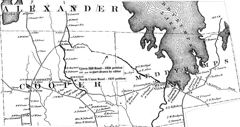
Map from George
Colby’s 1881 Atlas of Washington County –
1806 Petition from
Calais to Machias – showing County Road from Cooper PO – Grange Hall
Corner northerly to Frank Lane’s lot.
1826 Petition for
Green Hill Road
1821 Petition for Eastport to
Alexander Road
1826 Petition for Charlotte to
Alexander Road
1826 Petition for road from Cooper
PO to Meddybemps Village – Route 191
1835 Petition for
North Union Road
ROUTE 191 COOPER TO MEDDYBEMPS
VILLAGE – WCRB – Vol. 2, pg. 11 – MAP D
1826 Petition of Simeon Foster and
others
Whereas the road from Coopers
Mills [Grange Hall Corner in Cooper] to the lot occupied by Miles
Hill [just east of intersection with East Ridge Road] hence to
Gilman and Emerson Mills in No. 6 [Baring, but now Meddybemps
Village] and on to Eastport would be of public utility and thus we
pray the Court that road it be a County Road. This is the road
we now use.
GREEN HILL ROAD – WCRB –
Vol. 2, pg. 29 – MAP D
1827 Petition of Green Brown to
open the road from Peter Flood’s to Gilman and Emerson Mill in
Baring. Dismissed [The mill never moved, that part of Baring became
part of Meddybemps in 1842]
OLD CRAWFORD RD in Cooper –
LOVE LAKE RD in Crawford – WCRB - Vol. 2, pg. 40
1828 Petition of Simeon Foster and
others – MAPS A & D
To finish the road
approved in1823 through TWP #19 to Crawford; requesting $400 of the
proprietors of #19. Frederick Burrell of East Machias was named
agent.
MEDDYBEMPS TO BARING ROAD OR
ROUTE 191 – WCRB – Vol. 2, pg. 65 – 68 – MAP A
1829 Committee Report by Francis
Lowe, Moses Munson & Nathaniel Sawyer
Several attempts had been made to create a
shorter way between Gilman Mills [Meddybemps Village] and
Calais, each entering the County Road in Calais north of the
Magurrewock Bridge. All were dismissed by the Court. Finally the way
was submitted by the committee above for the new route.
…Starting at the
foot of McDougal Hill [Conant Hill] on the road leading from
Gilman’s Mill to Eastport Bridge following the best land to
the County Road near the Strickland House up river from
Baring Village.
The route is 7 ¾ miles + 16 rods, 4 rods wide.
AIRLINE ROAD – BREWER TO
BAILEYVILLE – HANCOCK CO. DEEDS – Vol.2, pg. 242
1829 Report of survey by Rufus
Gilmore, Samuel Lowder, Jr. and Andrew Strong – MAP E
A petition addressed to the
Supreme Judicial Court and asked for a four-rod road between Brewer
and Baileyville. The committee of three was to make a plan for the
new road and determine the probable cost of construction. The plan
for the road covers 15 pages detailing the entire 81 miles, 160
rods. The bill for the plan was $613.59 and was paid by the three
counties. The ‘Airline’ name didn’t come until after 1857. The
private road had been laid out by Bingham Heirs to encourage
settlement (and purchase) of their lands. This is the first official
mention of taxpayer money being connected to the road. It is likely
that much of the Airline Road was in use in 1829, but in poor
repair. It was a private road belonging to the proprietor, William
Bingham Heirs. Settlers would sign bonds (agreements) to purchase
land in exchange for money and work on the private road. Lack of
settlers in places made it impossible to maintain the road with this
labor.
MAP E - AIRLINE ROAD
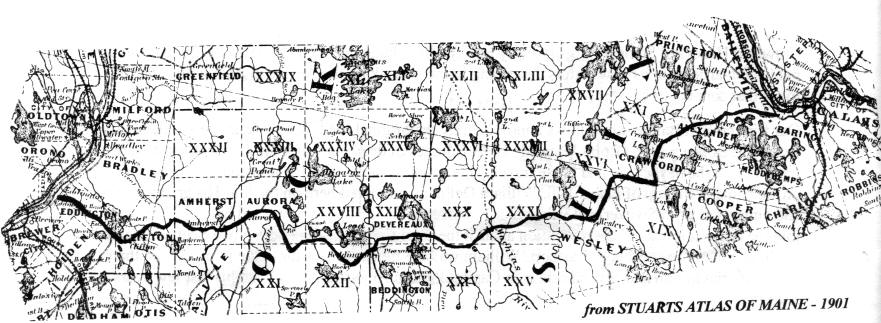
Map for 1829 Report &
Petitions of 1838, 1840 & 1852
GREEN HILL ROAD – WCRB –
Vol. 2, pg. 115 – MAP D
1830 Petition of Green Brown
The Petition was posted in the
towns and in the Northern Light, a newspaper in this county.
The committee met at Francis Low’s house [West Ridge Cooper], viewed
the road, and believed a road could be made without serious
difficulty.
ROUTE 192 FROM WESLEY TO
MACHIAS – WCRB – Vol. 2, pg. 99 – MAP A
1830 Petition of Robert H. Niles
and 14 other inhabitants of Great Meadow Ridge.
This requested the Court to open
the road that had been laid out and accepted by the Court,
but today is impassable and the 40 families cannot get to
market.
ROUTE 193 FROM BEDDINGTON TO
CHERRYFIELD – WCRB – Vol. 2, pg. 97 – MAP A
1831 Petition signed by Robert
Foster, Michael Patten and John Upton
The road approved in 1830 from the
north line of Cherryfield through Plantation #17 or Annsbourgh [Deblois]
and to the Blacks Road [Airline] in Plantation # 23 or Beddington
was never opened and is impassable. It needs to be opened for
the convenience and interest of the public. The Commission assessed
the proprietors of each plantation $1000, or about five cents per
acre, to open the road.
NORTH UNION ROAD IN COOPER–
WCRB – Vol. 2, pg. 324 – MAP D
1835 Report of Simeon Foster and
others
The committee recommends
discontinuance of the Green Hill Road because it runs through a
heath, a bog and a swamp. And instead of improving that road to
accept an existing road starting near
Daniel Lanes south line [near site of North Union Schoolhouse] and
going southeasterly to [Miles] Hill’s Corner on the County Road to
Calais [by Evergreen Cemetery].
SOUTH PRINCETON ROAD
– WCRB – Vol. 2,
pg. 297 – MAP B
1835 Petition of Peter Carle and
8 others - Peter Carle lived at in South
Princeton. Settlers could grow grain, but needed to get it ground
for human consumption. Carle has three choices for a grist mill,
Lewey’s Island [Princeton] Stephenson’s in Alexander, or a mill at
Baring. Early settlers of South Princeton told of carrying sacks of
grain on their backs to Baring, and they carried the food back.
This approved petition asked for a
county road from Stephenson’s Mills [at the foot of Pleasant Lake]
in Alexander through to the Houlton Road [by EMEC sub-station] in
Princeton. Part of this road was re-routed in Alexander in 1837
[Vol. 2, pg. 453] and about a half mile either side of the
Alexander/
Princeton line was moved westerly
in 1862 [Vol.4, pg 195]. [Part of this road [Old Cooper Road or Old
County Road] from the present Arm Road to the Airline Four Corners
was abandoned by the town at the March 31, 2009 annual Town Meeting]
CHARLOTTE ROAD – WCRB –
Vol. 2, pg. 412 – MAP A
1836 Petition by George Chase and
75 others.
The County was requested to lay
out a road from Calais to Charlotte starting near the end of the
Magurrewock Bridge in Calais and going southerly and westerly
through Baring and Charlotte to the County Road near the dwelling
house of David Blanchard, Esq. And westerly to Dennysville. This
is the road used today from Calais to Blanchard’s’ Corner and over
Smith Ridge to Dennysville.
GREEN HILL ROAD – WCRB –
Vol. 3, pg. 88 – MAP D
1837 Petition by John G. Taylor
and others to open the Green Hill Road - dismissed
NINETEEN ROAD - WCRB – Vol.
2, pg. 395 – MAP A
1837 Ordered that the sum of $450
be paid Elisha Hanscom to repair a road in Township #19 out of money
assessed to the proprietors of #19, as soon as the money is
collected. Petitions in 1829, 1831 and 1834 had requested money
for this road, but had been dismissed. One petition described the
road to be from Moses Ellsmore’s in TWP 18 to Abraham Fletcher’s in
#20. Moses’ house has risen again! This road runs from the
Airline in Crawford south through all of Township 19 and south
through most of Township 18 {Berry Township].
AIRLINE FROM CRAWFORD TO WESLEY
– WCRB – Vol. 2, pg. 514 – MAP A
1838 Petition by William Seavey
and 17 others
This asked for some adjustments
to the existing road starting about ¾ of a mile east of the East
Machias River at S. F. Hamscom’s place [Hanscom’s Mill, later the
Barstow place burned just before 1855, cellar with apple tree on
north side road by path to river] to the Wesley line. And asked
that it become a public road. The Airline, or
Penobscot to Schoodic Road or Blacks Road was a private road built
by the heirs of William Bingham to attract settlers to Bingham’s
land. John Black was Bingham’s agent. Settlers and petitioners
apparently felt it would be easier to get money for the road from
the County Commissioners. As we have seen, the Commissioners simply
assessed a tax on the proprietors (usually the Bingham Heirs).
The road is to be 4 rods wide and owners may remove their timber
within 12 months.
NEW AIRLINE ROAD IN ALEXANDER
– WCRB – Vol. 3, pg. 4 - MAP B
1839 Petition by John Gilman
Taylor and 69 others.
The record shows that in 1829 a
committee surveyed a road from the Penobscot River in the Town of
Brewer nearly opposite the mouth of the Kenduskeag Stream, so
called, and passing through several towns, plantations and
unorganized townships in the counties of Penobscot, Hancock and
Washington amongst which are the towns of Beddington, Wesley,
Crawford and Alexander and intersecting with the county road leading
from Machias to Calais in said Alexander near the house of Varen
Crafts [in lot 69]. The inhabitants of Alexander have opened and put
in repair a road partly in line of aforesaid road, but varying, and
nearly parallel to said road for a distance of about two miles
avoiding hills and bad ground, avoiding cultivated land and that no
person had suffered damages in the laying out of this new road. The
Commission met at the home of Jesse Stephenson and viewed the road
and required the change be advertised in the Frontier Journal
of Calais. The petition was approved. An on the ground study of
the original road shows that it crosses along a long stretch of side
hill in lots 76, 65, 66, and brooks in deep gullies on lots 65 and
67. No evidence of the original roadway is evident to me, but
several manmade land marks give hint to this original road. They are
Samuel Scribner’s cellar about ¼ mile south of the present Airline
on lot 76, Annaniah Bohanon’s cellar and family burying ground about
3/8 mile south of the Airline on lot 65, Solomon Strout’s cellar on
lot 66 (west part) and Jeremiah Frost’s family cemetery on lot 66
(west part). All these seem to be in a line that somewhat
approximated the original road. Are there other undiscovered sites
in that line? The Airline follows the top of the mentioned hill and
crosses the brooks on more level land.
AIRLINE ROAD – WCRB – Vol.
3, pgs. 40, 43, & 68 – MAP E
1840 & 1841 Petitions by George
Downes [lawyer and businessman] of Calais and others
These petitions pertained to
opening and making passable the Blacks Road in Wesley, and townships
29, 30, & 31. The Court eventually assessed the proprietor $1500 in
TWP 29, $2000 in TWP 30 and $2000 in TWP 31. [William Bingham’s
heirs were the proprietor and John Black their agent.] It was
felt that the few residents of those townships could not afford to
pay for the private road maintenance or actually maintain the roads
by their labor. Daniel Harwood [a Machias mill owner] in 1841
and 1844 petitioned for alterations and repairs on the Airline
through these same townships. .
ARM & BREAKNECK ROADS –
WCRB Vol. 3, pg. 230 – MAP B
1843 Petition by William Crockett
of Alexander & 42 others
This petition requested the county
take over the road from near Jacob Stevens Dwelling in Crawford
[corner Airline and Crawford Arm by the church] by homes of
Crockett, Knight, Fenlason & Lydick [along Arm Road] then by
Philips, Thurston, David Gooch & Hackett [on Breakneck Road in
Alexander], by David Vance [Breakneck Road in Cooper] and on to the
County Road [at Waterhouse Farm]. Committee found said road would
not be of public convenience or necessity. Petition dismissed and
petitioners pay costs. What a way to discourage petitions, you
win or you pay! [At some point the Breakneck Road did become a
County Road because in 1901 Gorham Flood and Charles Tyler,
Selectmen of Alexander petitioned to have this road from Fred
Vinings house south to the Cooper discontinued because no one lived
there and it cost too much to maintain. That petition was denied.]
AIRLINE ROAD
– WCRB – Vol. 3, pg. 469 – MAP E
1852 Petition by Edward Dyer
This petition was to open and make
passable a road through Township 24 known as the Blacks Road. The
Commission ordered that a copy of the petition be delivered to the
owners of Township 24 or their agent, plus a notice of same be
placed in the Frontier Journal, a Calais newspaper, advising
the owner or agent appear before the County Clerk and show cause why
said petition should not be granted.
CCC ROAD – PRINCETON TO WESLEY
ROAD – WCRB – Vol. 5, pg. 328 – MAP A
1895 Petition by Willis R. Dresser
and 189 others
[We note that a county road was
approved in 1859 from the Houlton Road into Plantation #21 [Big Lake
Township] – Vol 4, pg. 80. Dresser asked to continue that “Dixie”
Road southwesterly to intersect with the Crawford – Wesley Road by
Sand Knoll near the home of J. D. Day [in TWP 26] near the Wesley
line. It was to be of great convenience to people of Princeton and
up river in their travels to the Shiretown. Petition denied.
Today this private road is used for logging, riding recreation
vehicles and access to Clifford Lake. It passes through Big Lake
Township [TWP 21] and TWP 27.
CHARLOTTE – COOPER ROAD –
WCRB – Vol. 5, pg. 409 – MAP A
1898 Petition by Lincoln H.
Newbomb and 45 others
Requested a road from the
intersection of the Smith Ridge Road and Blanchards Corner roads in
Charlotte and running westerly, crossing the Dennys River at or near
the Haskell Smith Place in Cooper. Petition denied and petitioners
to pay county treasurer costs of $139.32. A rough road through
here had existed for nearly 80 years. One story tells that the first
iron (land) plow in Cooper was carried on its owner’s back from
Eastport over this road.
In 1901 many towns asked that their county roads be
designated as State Roads. County roads still exist in the
unorganized townships of Maine and are maintained, as such, by the
counties. The 110th
Legislature gave municipalities responsibility to maintain and
repair ‘all town or county ways’ that had not been discontinued or
abandoned by July 29, 1976. Under present law roads can be
discontinued in two ways. One is by a formal vote for discontinuance
by the legislative body of the municipality, i.e. the elected
council or town meeting. Alexander voters did this on March 30, 2009
For the ‘Old’ County Road. The other way is by 30 straight years of
non-maintenance.
|